TopoQuest Logo
Do you find TopoQuest useful?
Help keep TopoQuest running and adding new maps/features by donating!
Bitcoin:  19c7KJd3qBynnjoSw5npx9KScwjBe4ifkT
Litecoin:  LXs6TkuXGGXo1vDsWCkWVdjQX94eUKd6ui
Home View Maps Find Maps Find Places Resources & Links


Hatton, Alabama Topographic Map

USGS Map Title: Hatton, AL
USGS Map MRC: 34087E4
DRG (GeoTIFF) Download: o34087e4.tif


Neighboring USGS Topographic Map Quads:


  Leighton, AL  
34087F5
 

  Town Creek, AL  
34087F4
 

  Courtland, AL  
34087F3
 

  Old Bethel, AL  
34087E5
 

  Hatton, AL  
34087E4
 

  Masterson Mill, AL  
34087E3
 

  Newburg, AL  
34087D5
 

  Landersville, AL  
34087D4
 

  Moulton, AL  
34087D3


Map MRC Location:

N35°
W88°
N35°
W87°
H8 H7 H6 H5 H4 H3 H2 H1
G8 G7 G6 G5 G4 G3 G2 G1
F8 F7 F6 F5 F4 F3 F2 F1
E8 E7 E6 E5 E4 E3 E2 E1
D8 D7 D6 D5 D4 D3 D2 D1
C8 C7 C6 C5 C4 C3 C2 C1
B8 B7 B6 B5 B4 B3 B2 B1
A8 A7 A6 A5 A4 A3 A2 A1
N34°
W88°
N34°
W87°

Hatton, AL USGS 1:24K Topographic Map Preview:
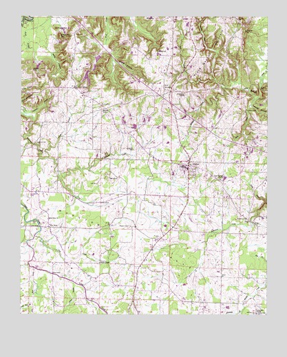
Hatton, AL USGS Topographic Map
Click on map above to begin viewing in our Map Viewer.

This topographic map contains these locations and features:
Feature Name Type Latitude Longitude GNIS ID View Map
Beavers CemeteryCemeteryN34.5881°W87.4561°113773View Map
Beavers CrossLocaleN34.5865°W87.4575°113774View Map
Beavers Cross School (historical)SchoolN34.5859°W87.4572°136731View Map
Beck CreekStreamN34.5987°W87.4022°113779View Map
Black Ground ChurchChurchN34.6220°W87.3872°114424View Map
Black Ground School (historical)SchoolN34.6223°W87.4150°136733View Map
Black Wax HillSummitN34.6168°W87.4809°114436View Map
Blackground CemeteryCemeteryN34.6217°W87.3882°2648310View Map
Calvary Baptist ChurchChurchN34.5820°W87.4142°136737View Map
Cedar Grove Church (historical)ChurchN34.5062°W87.4425°136739View Map
ConcordPopulated PlaceN34.5273°W87.4539°166064View Map
Concord Church (historical)ChurchN34.5273°W87.4547°136744View Map
Concord Post OfficePost OfficeN34.5273°W87.4539°169251View Map
Concord School (historical)SchoolN34.5268°W87.4528°136745View Map
Fergason CemeteryCemeteryN34.5373°W87.4453°118258View Map
Finney BranchStreamN34.5659°W87.4864°118295View Map
Flat RockPopulated PlaceN34.5368°W87.4853°118389View Map
Flat Rock Community CenterBuildingN34.5520°W87.4928°136757View Map
Flat Rock School (historical)SchoolN34.5509°W87.4928°136758View Map
Gum Springs ChurchChurchN34.5570°W87.3992°119489View Map
Hardin BridgeBridgeN34.5859°W87.3850°119718View Map
Harris BridgeBridgeN34.5370°W87.4900°119790View Map
Harris ChapelChurchN34.5218°W87.4600°119799View Map
HattonPopulated PlaceN34.5629°W87.4153°119853View Map
Hatton Census Designated PlaceCensusN34.5611°W87.4136°2628593View Map
Hatton Church of ChristChurchN34.5637°W87.4147°136768View Map
Hatton DivisionCivilN34.5676°W87.4176°165839View Map
Hatton Elementary SchoolSchoolN34.5626°W87.4178°136769View Map
Hatton High SchoolSchoolN34.5612°W87.4153°136770View Map
Hatton Volunteer Fire DepartmentBuildingN34.5648°W87.4142°2682866View Map
Hogwood BranchStreamN34.5837°W87.4984°120215View Map
Indian HillSummitN34.6029°W87.4945°120661View Map
Iron Bridge School (historical)SchoolN34.5431°W87.3889°136774View Map
Jetton CemeteryCemeteryN34.5906°W87.3761°120885View Map
King CemeteryCemeteryN34.5926°W87.4986°121212View Map
Lackey BridgeBridgeN34.5170°W87.4836°121301View Map
Lawrence County Associaton Church CampLocaleN34.5959°W87.3759°136780View Map
Little Mud CreekStreamN34.5195°W87.4934°159977View Map
Loosier HollowValleyN34.5879°W87.3831°122028View Map
Love CemeteryCemeteryN34.5548°W87.4617°122054View Map
Masterson CemeteryCemeteryN34.5720°W87.4917°122373View Map
Masterson School (historical)SchoolN34.5848°W87.4881°136746View Map
Mount Zion ChurchChurchN34.5959°W87.4717°136796View Map
Ne SmithPopulated PlaceN34.5962°W87.4284°123657View Map
Ne Smith School (historical)SchoolN34.5937°W87.4272°136797View Map
New Zion ChurchChurchN34.5404°W87.4856°123918View Map
Oak GrovePopulated PlaceN34.5579°W87.4511°156815View Map
Oak Grove School (historical)SchoolN34.5573°W87.4534°136801View Map
Oil Well BridgeBridgeN34.5948°W87.3789°124189View Map
Okalona Church (historical)ChurchN34.5768°W87.4436°1700605View Map
Okolona Baptist ChurchChurchN34.5626°W87.4164°152762View Map
Oliver CreekStreamN34.5909°W87.3817°124282View Map
Pilot KnobSummitN34.6201°W87.4825°124752View Map
Pool CreekStreamN34.5331°W87.4928°125129View Map
Pooles PondLakeN34.5994°W87.4666°125132View Map
Pooles Pond DamDamN34.6034°W87.4650°132025View Map
Prairie School (historical)SchoolN34.5193°W87.3986°1700606View Map
Prairie School (historical)SchoolN34.5045°W87.3900°136805View Map
Privet BranchStreamN34.5134°W87.4728°125292View Map
Providence Baptist ChurchChurchN34.5931°W87.4178°153086View Map
Providence CemeteryCemeteryN34.5931°W87.4186°1730274View Map
Randolph BranchStreamN34.5018°W87.3875°160470View Map
Roden CemeteryCemeteryN34.6176°W87.4731°125885View Map
Roden School (historical)SchoolN34.6168°W87.4725°136809View Map
Rutherford CemeteryCemeteryN34.5401°W87.3847°126050View Map
Sanderson CemeteryCemeteryN34.5695°W87.4439°126350View Map
Sanderson Chapel Methodist ChurchChurchN34.5676°W87.4400°164191View Map
Shaver HollowValleyN34.6059°W87.4536°126647View Map
Slayton HillSummitN34.5951°W87.3814°126964View Map
Soap Hole BranchStreamN34.5079°W87.4934°153497View Map
Taylors DamDamN34.6084°W87.4600°132026View Map
Taylors PondReservoirN34.6034°W87.4629°154141View Map
The Fall OffFallsN34.6106°W87.4320°127810View Map
Union Hill Missionary Baptist ChurchChurchN34.5007°W87.3803°164140View Map
Vickery LakeReservoirN34.5913°W87.3812°2777805View Map
Watches CreekStreamN34.5954°W87.3967°153897View Map
Willis HollowValleyN34.6140°W87.4881°129051View Map
Wolf SpringsPopulated PlaceN34.5951°W87.4728°154019View Map
Wolf Springs Elementary School (historical)SchoolN34.5918°W87.4689°165611View Map
Wolfe Spring ChurchChurchN34.5945°W87.4725°136825View Map

Note: Coordinates in the location and feature list above are referenced to NAD83 datum.


Copyright (C) 2008-2024 Ryan Niemi / Sunset Dynamics ... All Rights Reserved