TopoQuest Logo
Do you find TopoQuest useful?
Help keep TopoQuest running and adding new maps/features by donating!
Bitcoin:  19c7KJd3qBynnjoSw5npx9KScwjBe4ifkT
Litecoin:  LXs6TkuXGGXo1vDsWCkWVdjQX94eUKd6ui
Home View Maps Find Maps Find Places Resources & Links


Old Bethel, Alabama Topographic Map

USGS Map Title: Old Bethel, AL
USGS Map MRC: 34087E5
DRG (GeoTIFF) Download: o34087e5.tif


Neighboring USGS Topographic Map Quads:


  Tuscumbia, AL  
34087F6
 

  Leighton, AL  
34087F5
 

  Town Creek, AL  
34087F4
 

  Russellville, AL  
34087E6
 

  Old Bethel, AL  
34087E5
 

  Hatton, AL  
34087E4
 

  Spruce Pine, AL  
34087D6
 

  Newburg, AL  
34087D5
 

  Landersville, AL  
34087D4


Map MRC Location:

N35°
W88°
N35°
W87°
H8 H7 H6 H5 H4 H3 H2 H1
G8 G7 G6 G5 G4 G3 G2 G1
F8 F7 F6 F5 F4 F3 F2 F1
E8 E7 E6 E5 E4 E3 E2 E1
D8 D7 D6 D5 D4 D3 D2 D1
C8 C7 C6 C5 C4 C3 C2 C1
B8 B7 B6 B5 B4 B3 B2 B1
A8 A7 A6 A5 A4 A3 A2 A1
N34°
W88°
N34°
W87°

Old Bethel, AL USGS 1:24K Topographic Map Preview:
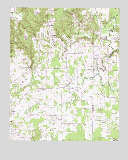
Old Bethel, AL USGS Topographic Map
Click on map above to begin viewing in our Map Viewer.

This topographic map contains these locations and features:
Feature Name Type Latitude Longitude GNIS ID View Map
Abbey Post Office (historical)Post OfficeN34.5459°W87.5689°166634View Map
Antioch ChurchChurchN34.5073°W87.6189°113175View Map
Avoca (historical)Populated PlaceN34.5751°W87.5056°149784View Map
Aycock CemeteryCemeteryN34.5687°W87.5997°113317View Map
Bean BridgeBridgeN34.5956°W87.5147°113626View Map
Bethel School (historical)SchoolN34.5737°W87.5253°132818View Map
BethsaidaPopulated PlaceN34.5537°W87.5567°136124View Map
Bethsaida CemeteryCemeteryN34.5548°W87.5561°136125View Map
Bethsaida ChurchChurchN34.5545°W87.5572°114160View Map
Bob Saints CemeteryCemeteryN34.5543°W87.5889°149514View Map
Boston School (historical)SchoolN34.5026°W87.6125°136129View Map
Bruton School (historical)SchoolN34.5487°W87.5703°136131View Map
Bull Skull CreekStreamN34.6187°W87.6181°115184View Map
C C Smith Elementary SchoolSchoolN34.5415°W87.5178°165533View Map
Cabin BranchStreamN34.6206°W87.6242°115351View Map
Center View School (historical)SchoolN34.5712°W87.6181°132832View Map
Clemments Mill (historical)LocaleN34.5654°W87.5614°136142View Map
Collins MountainSummitN34.6115°W87.5181°116447View Map
Counts CemeteryCemeteryN34.5023°W87.6036°116706View Map
Doss HollowValleyN34.5904°W87.5595°117390View Map
Foxtrap CreekStreamN34.5951°W87.6186°118586View Map
Gargas CemeteryCemeteryN34.5634°W87.5295°118831View Map
Gargis CemeteryCemeteryN34.5940°W87.5572°118832View Map
Gin House HollowValleyN34.5951°W87.5545°118996View Map
Harmony Freewill Baptist ChurchChurchN34.6181°W87.5270°119760View Map
Hickory Grove School (historical)SchoolN34.5493°W87.5664°136183View Map
Hollow Field BranchStreamN34.5993°W87.5489°120262View Map
Hopewell Church of ChristChurchN34.5987°W87.5775°120385View Map
Hopewell School (historical)SchoolN34.5990°W87.5770°132916View Map
Jack PointCapeN34.6084°W87.6125°120748View Map
King HollowValleyN34.5981°W87.5078°121227View Map
Kirby Bridge (historical)BridgeN34.5676°W87.5195°132933View Map
La GrangePopulated PlaceN34.5820°W87.5472°132946View Map
La Grange SchoolSchoolN34.5826°W87.5475°155127View Map
LaGrange Volunteer Fire DepartmentBuildingN34.5814°W87.5444°2682993View Map
Lick BranchStreamN34.5529°W87.5197°121587View Map
Little Mud CreekStreamN34.5331°W87.5700°121826View Map
Masterson CreekStreamN34.5859°W87.5072°152246View Map
McAfee CreekStreamN34.6051°W87.5181°152258View Map
McBride BranchStreamN34.6037°W87.6006°122450View Map
McCorkles GapGapN34.6243°W87.5889°132954View Map
Midway Freewill Baptist ChurchChurchN34.5823°W87.5522°152317View Map
Midway Methodist Church (historical)ChurchN34.5820°W87.5464°132958View Map
Mount Moriah School (historical)SchoolN34.6240°W87.6195°132968View Map
Mud CreekStreamN34.5631°W87.5245°160197View Map
Mud Creek School (historical)SchoolN34.5195°W87.5659°136215View Map
Mulwee BranchStreamN34.5684°W87.5253°123587View Map
New La Grange ChurchChurchN34.6087°W87.5825°123854View Map
Old BethelPopulated PlaceN34.5812°W87.5236°152765View Map
Old Bethel Baptist ChurchChurchN34.5773°W87.5256°152768View Map
Pane (historical)Populated PlaceN34.5806°W87.5792°166026View Map
Pane Post Office (historical)Post OfficeN34.5806°W87.5792°169298View Map
Pennington CemeteryCemeteryN34.5398°W87.6103°124590View Map
Poplar CreekStreamN34.6151°W87.5075°153034View Map
Poplar Creek (historical)Populated PlaceN34.6126°W87.5417°132996View Map
Poplar Creek Missionary Baptist ChurchChurchN34.6123°W87.5431°153035View Map
Poplar Creek School (historical)SchoolN34.6140°W87.5342°132997View Map
Prairie Grove ChurchChurchN34.5295°W87.5234°125240View Map
Prairie Grove School (historical)SchoolN34.5193°W87.5222°136803View Map
Rock CreekStreamN34.5531°W87.5425°125754View Map
Rocky Glen Elementary SchoolSchoolN34.5101°W87.6148°165518View Map
Saints CrossroadsPopulated PlaceN34.5490°W87.5889°126227View Map
Sibley CemeteryCemeteryN34.5093°W87.5872°136275View Map
Smith CreekStreamN34.5093°W87.5789°160634View Map
Stillhouse HollowValleyN34.5884°W87.5006°127406View Map
Tharptown Junior High SchoolSchoolN34.5270°W87.6209°141104View Map
Tharptown Volunteer Fire DepartmentBuildingN34.5254°W87.6231°2683464View Map
Vandiver Brothers LakeReservoirN34.5968°W87.5334°132023View Map
Vandiver Brothers Lake DamDamN34.5968°W87.5334°132024View Map
Watson Spring BranchStreamN34.5998°W87.5470°128646View Map
Whitlock BranchStreamN34.5506°W87.6081°128925View Map
Zion Hill Baptist ChurchChurchN34.5970°W87.5206°133080View Map

Note: Coordinates in the location and feature list above are referenced to NAD83 datum.


Copyright (C) 2008-2025 Ryan Niemi / Sunset Dynamics ... All Rights Reserved