TopoQuest Logo
Do you find TopoQuest useful?
Help keep TopoQuest running and adding new maps/features by donating!
Bitcoin:  19c7KJd3qBynnjoSw5npx9KScwjBe4ifkT
Litecoin:  LXs6TkuXGGXo1vDsWCkWVdjQX94eUKd6ui
Home View Maps Find Maps Find Places Resources & Links


Newburg, Alabama Topographic Map

USGS Map Title: Newburg, AL
USGS Map MRC: 34087D5
DRG (GeoTIFF) Download: o34087d5.tif


Neighboring USGS Topographic Map Quads:


  Russellville, AL  
34087E6
 

  Old Bethel, AL  
34087E5
 

  Hatton, AL  
34087E4
 

  Spruce Pine, AL  
34087D6
 

  Newburg, AL  
34087D5
 

  Landersville, AL  
34087D4
 

  Phil Campbell, AL  
34087C6
 

  Kinlock Spring, AL  
34087C5
 

  Bee Branch, AL  
34087C4


Map MRC Location:

N35°
W88°
N35°
W87°
H8 H7 H6 H5 H4 H3 H2 H1
G8 G7 G6 G5 G4 G3 G2 G1
F8 F7 F6 F5 F4 F3 F2 F1
E8 E7 E6 E5 E4 E3 E2 E1
D8 D7 D6 D5 D4 D3 D2 D1
C8 C7 C6 C5 C4 C3 C2 C1
B8 B7 B6 B5 B4 B3 B2 B1
A8 A7 A6 A5 A4 A3 A2 A1
N34°
W88°
N34°
W87°

Newburg, AL USGS 1:24K Topographic Map Preview:
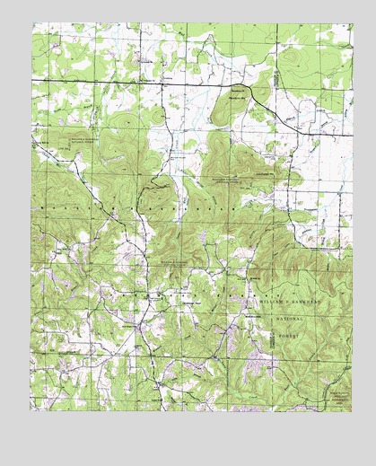
Newburg, AL USGS Topographic Map
Click on map above to begin viewing in our Map Viewer.

This topographic map contains these locations and features:
Feature Name Type Latitude Longitude GNIS ID View Map
Atwood BranchStreamN34.4712°W87.5025°159093View Map
Beulah CemeteryCemeteryN34.4173°W87.5389°161768View Map
Beulah ChurchChurchN34.4173°W87.5397°161769View Map
Borden BranchStreamN34.4348°W87.5117°159235View Map
Cherry Hill CemeteryCemeteryN34.4618°W87.6239°161770View Map
Cherry Hill ChurchChurchN34.4609°W87.6239°159385View Map
Cherry Hill School (historical)SchoolN34.4609°W87.6242°1700424View Map
Coffin HollowValleyN34.4668°W87.5559°159422View Map
County Line School (historical)SchoolN34.4143°W87.5303°161816View Map
County Line School (historical)SchoolN34.4562°W87.5247°161817View Map
Denton HollowValleyN34.4498°W87.5686°159498View Map
Denton Hollow CemeteryCemeteryN34.4565°W87.5722°159499View Map
Duboise CemeteryCemeteryN34.3956°W87.5847°159531View Map
East Franklin Junior High SchoolSchoolN34.3840°W87.5764°161773View Map
East Franklin Volunteer Fire DepartmentBuildingN34.3928°W87.5918°2682721View Map
Eckerberger MountainRidgeN34.4520°W87.5347°159555View Map
Gray Rock CemeteryCemeteryN34.4279°W87.6109°161774View Map
Gray Rock ChurchChurchN34.4279°W87.6109°159692View Map
Hooker Spring BranchStreamN34.4540°W87.5697°159797View Map
Kimbrough CemeteryCemeteryN34.4134°W87.5697°159896View Map
Kimbrough ChapelChurchN34.4098°W87.5659°161775View Map
Kirby Store (historical)LocaleN34.4020°W87.5470°161776View Map
Light House ChurchChurchN34.4726°W87.5325°162946View Map
Little BranchStreamN34.3848°W87.5489°159957View Map
Macedonia CemeteryCemeteryN34.4795°W87.5472°161777View Map
Macedonia ChurchChurchN34.4790°W87.5484°160021View Map
Macedonia MountainSummitN34.4768°W87.5450°160023View Map
McBrayer LakeReservoirN34.4451°W87.5634°161525View Map
McNair CreekStreamN34.3754°W87.5314°160078View Map
Mount Pleasant CemeteryCemeteryN34.4812°W87.5839°161778View Map
Mount Pleasant United Methodist ChurchChurchN34.4815°W87.5845°160176View Map
Mountain Home ChurchChurchN34.4362°W87.5964°161779View Map
New Hope ChurchChurchN34.4023°W87.5845°160243View Map
NewburgPopulated PlaceN34.4804°W87.5759°160249View Map
Oak GrovePopulated PlaceN34.4129°W87.5792°161780View Map
Oak Grove CemeteryCemeteryN34.4118°W87.5792°161781View Map
Oak Grove ChurchChurchN34.4115°W87.5795°160270View Map
Pine ChapelChurchN34.4143°W87.5692°161785View Map
Piney Grove School (historical)SchoolN34.4062°W87.5420°161786View Map
Pleasant Hill ChurchChurchN34.3962°W87.5881°161787View Map
Robertson CreekStreamN34.4415°W87.5103°160501View Map
Robertsons LakeReservoirN34.4434°W87.5334°161522View Map
Rocky BranchStreamN34.4732°W87.5995°160520View Map
Sand Pit New Hope Church DamDamN34.3934°W87.6084°132001View Map
Sand Pit New Hope Church LakeReservoirN34.3930°W87.6067°161517View Map
Steele HollowValleyN34.4298°W87.5225°160670View Map
Stillhouse HollowValleyN34.4420°W87.5322°160675View Map
Sylvester CemeteryCemeteryN34.4879°W87.5836°161790View Map
Sylvester ChurchChurchN34.4882°W87.5847°160704View Map
Tanyard BranchStreamN34.4698°W87.5022°160712View Map
Templeton CemeteryCemeteryN34.4579°W87.5306°160731View Map
Town Creek Watershed Dam Number 11DamN34.4451°W87.5634°161524View Map
Town Creek Watershed Dam Number 12DamN34.4441°W87.5340°161523View Map
Trapp School (historical)SchoolN34.3832°W87.6134°161791View Map
UnionPopulated PlaceN34.3773°W87.5742°161793View Map
Union ChurchChurchN34.3793°W87.5739°161794View Map
Union Junior High SchoolSchoolN34.3787°W87.5736°165562View Map
West Store (historical)LocaleN34.3918°W87.5934°161795View Map
Woodall CreekStreamN34.3962°W87.5570°160867View Map

Note: Coordinates in the location and feature list above are referenced to NAD83 datum.


Copyright (C) 2008-2024 Ryan Niemi / Sunset Dynamics ... All Rights Reserved