TopoQuest Logo
Do you find TopoQuest useful?
Help keep TopoQuest running and adding new maps/features by donating!
Bitcoin:  19c7KJd3qBynnjoSw5npx9KScwjBe4ifkT
Litecoin:  LXs6TkuXGGXo1vDsWCkWVdjQX94eUKd6ui
Home View Maps Find Maps Find Places Resources & Links


Hayesville, North Carolina Topographic Map

USGS Map Title: Hayesville, NC
USGS Map MRC: 35083A7
DRG (GeoTIFF) Download: o35083a7.tif


Neighboring USGS Topographic Map Quads:


  Marble, NC  
35083B8
 

  Andrews, NC  
35083B7
 

  Topton, NC  
35083B6
 

  Peachtree, NC  
35083A8
 

  Hayesville, NC  
35083A7
 

  Shooting Creek, NC  
35083A6
 

  Blairsville, GA  
34083H8
 

  Hiawassee, GA  
34083H7
 

  Macedonia, GA  
34083H6


Map MRC Location:

N36°
W84°
N36°
W83°
H8 H7 H6 H5 H4 H3 H2 H1
G8 G7 G6 G5 G4 G3 G2 G1
F8 F7 F6 F5 F4 F3 F2 F1
E8 E7 E6 E5 E4 E3 E2 E1
D8 D7 D6 D5 D4 D3 D2 D1
C8 C7 C6 C5 C4 C3 C2 C1
B8 B7 B6 B5 B4 B3 B2 B1
A8 A7 A6 A5 A4 A3 A2 A1
N35°
W84°
N35°
W83°

Hayesville, NC USGS 1:24K Topographic Map Preview:
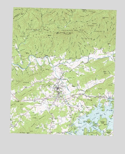
Hayesville, NC USGS Topographic Map
Click on map above to begin viewing in our Map Viewer.

This topographic map contains these locations and features:
Feature Name Type Latitude Longitude GNIS ID View Map
Allbone BranchStreamN35.0773°W83.8477°1008673View Map
Armstrong CoveBayN35.0004°W83.7988°1008768View Map
Armstrong DockLocaleN35.0029°W83.8032°1008771View Map
Ashe KnobSummitN35.0498°W83.7568°1018862View Map
Barlow High TopSummitN35.0798°W83.8588°1018966View Map
Barnard BridgeBridgeN35.0229°W83.7893°1008927View Map
Bee BranchStreamN35.1070°W83.8355°1009094View Map
Blair CreekStreamN35.0323°W83.8074°1009464View Map
Boardtree BranchStreamN35.0901°W83.7830°1009512View Map
Boardtree RidgeRidgeN35.0915°W83.7910°1009513View Map
Bob BranchStreamN35.0773°W83.8346°1009515View Map
Bob Prater BranchStreamN35.0581°W83.7566°1009519View Map
Bristol BranchStreamN35.0715°W83.8068°1009614View Map
Bristol CampLocaleN35.1079°W83.8110°1009615View Map
Bristol Hunter CampLocaleN35.1045°W83.8188°1018180View Map
Bristol RidgeRidgeN35.0898°W83.8049°1009616View Map
Buckner BranchStreamN35.0734°W83.7985°1009779View Map
Byers BranchStreamN35.0356°W83.7671°1009871View Map
Caesar Austin BranchStreamN35.0762°W83.7916°1009894View Map
Canup RidgeRidgeN35.0859°W83.8274°1010030View Map
Carroll GapGapN35.0454°W83.8549°1018188View Map
Carroll MountainSummitN35.0509°W83.8605°1019540View Map
Carver CreekStreamN35.0734°W83.8296°1010075View Map
Carver GapGapN35.1006°W83.8218°1010076View Map
Chambers CoveBayN35.0331°W83.7549°1010158View Map
Chatuge DamDamN35.0176°W83.7913°983062View Map
Cherry MountainSummitN35.0106°W83.8441°1019618View Map
Chestnut Stomp KnobSummitN35.1173°W83.7666°1019656View Map
Clay CountyCivilN35.0572°W83.7502°1008546View Map
Clay County Ambulance ServiceBuildingN35.0377°W83.8279°2720407View Map
Clay County Fire and Rescue SquadBuildingN35.0457°W83.8205°2639577View Map
Clay County ParkParkN35.0062°W83.7977°1010303View Map
Clay County Sheriff's OfficeBuildingN35.0416°W83.8294°2769664View Map
Cold Spring GapGapN35.1095°W83.7838°1010385View Map
Coleman CreekStreamN35.0065°W83.8260°1010404View Map
Coot CoveValleyN35.0638°W83.8526°1010475View Map
Crawford BranchStreamN35.0379°W83.7560°1010568View Map
Dan KnobSummitN35.0468°W83.7649°1019899View Map
Deep GapGapN35.1040°W83.8007°1010733View Map
Dick BranchStreamN35.0762°W83.7821°1010801View Map
Double KnobsSummitN35.0654°W83.7643°1020009View Map
Downing CreekStreamN35.0409°W83.8032°1010901View Map
Downing Creek ChurchChurchN35.0448°W83.7830°1010902View Map
Dyer TopSummitN35.0520°W83.8643°1020064View Map
Evans BranchStreamN35.0854°W83.7724°1011112View Map
Evans RidgeRidgeN35.1048°W83.7688°1011117View Map
Fender KnobSummitN35.1231°W83.7780°1020229View Map
Fires CreekPopulated PlaceN35.0770°W83.8641°1011216View Map
Fires CreekStreamN35.0681°W83.8682°1020247View Map
Fires Creek CampLocaleN35.0876°W83.8682°1018191View Map
Fires Creek CemeteryCemeteryN35.0748°W83.8738°1011217View Map
Fires Creek ChurchChurchN35.0748°W83.8718°1018193View Map
Fires Creek Picnic AreaLocaleN35.0959°W83.8588°1018163View Map
Flintspring BranchStreamN35.1215°W83.8035°1011292View Map
Fork RidgeRidgeN35.1234°W83.7730°1011335View Map
Fort HillSummitN35.0370°W83.8235°1020329View Map
Game BranchStreamN35.1206°W83.8343°1011430View Map
George W Truett CampLocaleN35.0384°W83.8452°1011467View Map
Gibby IslandIslandN35.0131°W83.7916°1011481View Map
Gibson CoveBayN35.0104°W83.7982°1018181View Map
Graveyard High TopSummitN35.0981°W83.8330°1020527View Map
Graveyard RidgeRidgeN35.0848°W83.8360°1011669View Map
Greasy CreekStreamN35.0706°W83.8138°1011684View Map
Haigler Camp BranchStreamN35.1248°W83.8499°1011791View Map
HayesvillePopulated PlaceN35.0462°W83.8180°1011930View Map
Hayesville CemeteryCemeteryN35.0237°W83.7941°1011931View Map
Hayesville ChurchChurchN35.0351°W83.8343°1011932View Map
Hayesville Elementary SchoolSchoolN35.0415°W83.8174°1017570View Map
Hayesville High SchoolSchoolN35.0409°W83.8160°1017571View Map
Hayesville Post OfficePost OfficeN35.0463°W83.8166°2773875View Map
Hayesville ReservoirReservoirN35.0490°W83.8280°1011933View Map
Hickory Cove CreekStreamN35.1218°W83.8421°1012002View Map
Hinton Rural Life CenterBuildingN35.0301°W83.7716°1012078View Map
Holden CoveValleyN35.0527°W83.7720°1012123View Map
Horselot CoveValleyN35.0934°W83.7776°1012211View Map
Huskins BranchStreamN35.0870°W83.8663°1012314View Map
Hyatt Mill CreekStreamN35.0295°W83.8021°1012321View Map
Ivy KnobSummitN35.0290°W83.8638°1020906View Map
Jackrabbit CampgroundLocaleN35.0112°W83.7727°1012398View Map
Jackrabbit MountainSummitN35.0115°W83.7616°1020917View Map
Jackrabbit Mountain Picnic AreaLocaleN35.0106°W83.7666°1018182View Map
Jake CoveValleyN35.1117°W83.8525°1012422View Map
Jake Deal CoveValleyN35.0806°W83.8659°1012423View Map
Jim Carroll TopSummitN35.0509°W83.8607°1012476View Map
Joe KnobSummitN35.0020°W83.8507°1020958View Map
John Reese BranchStreamN35.0412°W83.7868°1012504View Map
Johnson CreekStreamN35.0770°W83.7766°1012532View Map
Julie High TopSummitN35.1001°W83.8121°1021001View Map
Julie RidgeRidgeN35.0884°W83.8149°1012576View Map
Ketron Camp BranchStreamN35.1212°W83.8030°1012614View Map
Kimball GapGapN35.0004°W83.8543°1012622View Map
Kimsey BranchStreamN35.0320°W83.8471°1012623View Map
Kimsey RidgeRidgeN35.0409°W83.8552°1012628View Map
Lance CoveValleyN35.0670°W83.8717°1012671View Map
Laurel CreekStreamN35.1173°W83.8396°1012727View Map
Leatherwood BranchStreamN35.0962°W83.8588°1012766View Map
Leatherwood FallsFallsN35.0965°W83.8594°1012772View Map
Ledford BranchStreamN35.0837°W83.8696°1012779View Map
Ledford CemeteryCemeteryN35.0306°W83.7571°1012781View Map
Ledford ChapelChurchN35.0370°W83.7571°1012787View Map
Left Prong Johnson CreekStreamN35.1045°W83.7555°1012814View Map
Lemon CoveBayN35.0040°W83.7946°1012821View Map
Licklog CreekStreamN35.0226°W83.7610°1012857View Map
Little Fires CreekStreamN35.1109°W83.8077°1012960View Map
Logan CoveValleyN35.0637°W83.8578°1013078View Map
Logan Cove BranchStreamN35.0643°W83.8585°1018192View Map
Lower Tusquitee BridgeBridgeN35.0704°W83.8168°1013249View Map
Lyon BranchStreamN35.0715°W83.8130°1013273View Map
Martin Hill ChurchChurchN35.0754°W83.8393°1013344View Map
Matheson CoveValleyN35.0067°W83.8295°1013367View Map
McClure CemeteryCemeteryN35.0084°W83.7988°1013400View Map
Meadow Grove ChurchChurchN35.0659°W83.8157°1013457View Map
Merry IslandIslandN35.0259°W83.7560°1013472View Map
Mob BranchStreamN35.0781°W83.8513°1013642View Map
Moody CoveValleyN35.0094°W83.8732°1013664View Map
Moss ChurchChurchN35.0818°W83.7624°1013721View Map
Mule Flats BendBendN35.1248°W83.7893°1013831View Map
Mull CoveValleyN35.0832°W83.7574°1013836View Map
Myers ChapelChurchN35.0026°W83.8068°1013862View Map
Nantahala Purchase UnitParkN35.0181°W83.7999°1018069View Map
Newt RidgeRidgeN35.0904°W83.8410°1013952View Map
North Fork Blair CreekStreamN35.0251°W83.8302°1013990View Map
Oak Forest ChurchChurchN35.0368°W83.7938°1014048View Map
Oakview ChurchChurchN35.0781°W83.7524°1014068View Map
Old House BranchStreamN35.0798°W83.8446°1014095View Map
Omphus RidgeRidgeN35.1026°W83.8349°1014117View Map
Orators KnobSummitN35.0376°W83.8160°1014126View Map
Owenby CoveValleyN35.0700°W83.8432°1014152View Map
Padgett BranchStreamN35.0409°W83.7941°1014175View Map
Passmore BranchStreamN35.0654°W83.8721°1014243View Map
Patterson BranchStreamN35.0370°W83.7532°1014253View Map
Peckerwood BranchStreamN35.0790°W83.7563°1014294View Map
Pendergrass BranchStreamN35.0893°W83.8674°1014311View Map
Penland IslandIslandN35.0140°W83.7799°992029View Map
Philadelphia ChurchChurchN35.0009°W83.7618°1014360View Map
Philadelphia Church CoveBayN35.0068°W83.7702°1014361View Map
Phone Line GapGapN35.1018°W83.8071°1014379View Map
Pigpen BranchStreamN35.0884°W83.7780°1014391View Map
Pigpen GapGapN35.1040°W83.7943°1014394View Map
Pigpen KnobSummitN35.1026°W83.7957°1021893View Map
Pine CoveValleyN35.1118°W83.8303°1014415View Map
Pine Grove ChurchChurchN35.0162°W83.8213°1014421View Map
Pine RidgeRidgeN35.0990°W83.7868°1014431View Map
Piney MountainSummitN35.0626°W83.8360°1021956View Map
Pitts CoveBayN35.0301°W83.7674°1014501View Map
Polecat GapGapN35.0915°W83.7596°1014561View Map
Poplar CoveValleyN35.0675°W83.8396°1014576View Map
Qually CreekStreamN35.0576°W83.8188°1014679View Map
Rockhouse CreekStreamN35.1084°W83.8382°1015010View Map
Rocky Cove BranchStreamN35.1173°W83.8057°1015034View Map
Rocky CreekStreamN35.1026°W83.7782°1015035View Map
Saddle Dam 1DamN35.0095°W83.8005°1015148View Map
Saddle Dam 2DamN35.0212°W83.7843°1015149View Map
Saddle Dam 3DamN35.0256°W83.7757°1015150View Map
Sanderson BridgeBridgeN35.0551°W83.8160°1015224View Map
Sanderson CoveValleyN35.0552°W83.8063°1015225View Map
Sawyer CoveValleyN35.0631°W83.7978°1015304View Map
Schoolhouse BranchStreamN35.0770°W83.7877°1015320View Map
Schoolhouse HillSummitN35.0343°W83.7757°1022519View Map
Sewell CoveValleyN35.0989°W83.7809°1015366View Map
Shady Grove ChurchChurchN35.0123°W83.8643°1015372View Map
Shearer CreekStreamN35.0845°W83.7741°1015396View Map
Shearer GapGapN35.1115°W83.7791°1015397View Map
ShewbirdPopulated PlaceN35.0084°W83.8332°1023424View Map
Shiloh ChurchChurchN35.0673°W83.7924°1015431View Map
Shoal BranchStreamN35.0929°W83.7613°1015448View Map
Shoal RidgeRidgeN35.1084°W83.7616°1015463View Map
Shortoff KnobSummitN35.1187°W83.8660°1022615View Map
Smackass GapGapN35.0387°W83.7696°1015599View Map
Snake BranchStreamN35.1093°W83.7571°1015624View Map
Snake RidgeRidgeN35.1145°W83.7530°1015627View Map
South Fork Blair CreekStreamN35.0251°W83.8302°1015684View Map
Squirrel Spring GapGapN35.1006°W83.8110°1015770View Map
Stable BranchStreamN35.0787°W83.7866°1015771View Map
Stillhouse BranchStreamN35.0820°W83.8452°1015841View Map
Sweetwater GapGapN35.0323°W83.8641°1015991View Map
Tarkiln RidgeRidgeN35.1156°W83.8485°1016030View Map
Tom CoveValleyN35.1041°W83.8513°1016177View Map
Town CreekStreamN35.0484°W83.8080°1016201View Map
Town MountainSummitN35.0481°W83.8377°1022974View Map
Town of HayesvilleCivilN35.0464°W83.8181°2405807View Map
Township of HayesvilleCivilN35.0411°W83.8231°1026555View Map
Township of HiawasseeCivilN35.0189°W83.7510°1026556View Map
Trail RidgeRidgeN35.1193°W83.8155°1016215View Map
Truett Memorial ChurchChurchN35.0468°W83.8199°1016242View Map
TusquiteePopulated PlaceN35.0845°W83.7657°1023021View Map
Tusquitee CreekStreamN35.0670°W83.8238°1016295View Map
Upper Tusquitee BridgeBridgeN35.0815°W83.7518°1016348View Map
Venus GapGapN35.1181°W83.7896°1016370View Map
Walnut CoveValleyN35.0628°W83.8617°1016417View Map
Webb CreekStreamN35.0065°W83.8721°1016492View Map
Wheeler BranchStreamN35.1095°W83.8093°1016567View Map
Winchester CoveValleyN35.0646°W83.7816°1016737View Map
Wolf RidgeRidgeN35.1229°W83.8232°1016788View Map
Wolfpen BranchStreamN35.1112°W83.8249°1016793View Map

Note: Coordinates in the location and feature list above are referenced to NAD83 datum.


Copyright (C) 2008-2024 Ryan Niemi / Sunset Dynamics ... All Rights Reserved