TopoQuest Logo
Do you find TopoQuest useful?
Help keep TopoQuest running and adding new maps/features by donating!
Bitcoin:  19c7KJd3qBynnjoSw5npx9KScwjBe4ifkT
Litecoin:  LXs6TkuXGGXo1vDsWCkWVdjQX94eUKd6ui
Home View Maps Find Maps Find Places Resources & Links


Heatwole, Minnesota Topographic Map

USGS Map Title: Heatwole, MN
USGS Map MRC: 44094G4
DRG (GeoTIFF) Download: o44094g4.tif


Neighboring USGS Topographic Map Quads:


  Cedar Mills, MN  
44094H5
 

  Hutchinson West, MN  
44094H4
 

  Hutchinson East, MN  
44094H3
 

  Lake Allie, MN  
44094G5
 

  Heatwole, MN  
44094G4
 

  Biscay, MN  
44094G3
 

  Buffalo Lake, MN  
44094F5
 

  Stewart, MN  
44094F4
 

  Brownton, MN  
44094F3


Map MRC Location:

N45°
W95°
N45°
W94°
H8 H7 H6 H5 H4 H3 H2 H1
G8 G7 G6 G5 G4 G3 G2 G1
F8 F7 F6 F5 F4 F3 F2 F1
E8 E7 E6 E5 E4 E3 E2 E1
D8 D7 D6 D5 D4 D3 D2 D1
C8 C7 C6 C5 C4 C3 C2 C1
B8 B7 B6 B5 B4 B3 B2 B1
A8 A7 A6 A5 A4 A3 A2 A1
N44°
W95°
N44°
W94°

Heatwole, MN USGS 1:24K Topographic Map Preview:
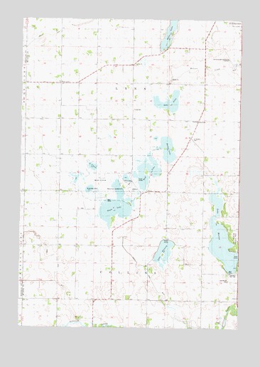
Heatwole, MN USGS Topographic Map
Click on map above to begin viewing in our Map Viewer.

This topographic map contains these locations and features:
Feature Name Type Latitude Longitude GNIS ID View Map
Barber LakeLakeN44.8224°W94.4169°639624View Map
County Ditch Number ThirtythreeCanalN44.7714°W94.4267°1817760View Map
Eagle LakeLakeN44.7990°W94.4459°643015View Map
HeatwolePopulated PlaceN44.8341°W94.3997°654750View Map
Heatwole Post Office (historical)Post OfficeN44.8342°W94.3994°2065369View Map
Hutchinson Municipal Airport-Butler FieldAirportN44.8589°W94.3818°660222View Map
Judicial Ditch Number FourCanalN44.7722°W94.4783°1817759View Map
Lake AllenLakeN44.8414°W94.4160°643277View Map
Lake ClaraLakeN44.8155°W94.4592°1817762View Map
Lake MarionLakeN44.7833°W94.3847°647540View Map
Lake Marion CampgroundLocaleN44.7817°W94.3778°2065282View Map
Lake Marion CemeteryCemeteryN44.7694°W94.3816°1817757View Map
Lake Marion County ParkParkN44.7869°W94.3780°1817758View Map
Lake WhitneyLakeN44.7816°W94.4178°654119View Map
Life Link III HutchinsonBuildingN44.8600°W94.3793°2721388View Map
Lynndale SchoolSchoolN44.8194°W94.4669°647336View Map
Marion LakeReservoirN44.7716°W94.3803°1776158View Map
Marion Lake DamDamN44.7716°W94.3803°1776157View Map
McLeod County FairgroundsLocaleN44.8736°W94.3847°2065323View Map
Mud LakeLakeN44.8098°W94.4284°648221View Map
Ras-Lynn State Wildlife Management AreaParkN44.8083°W94.4497°1817761View Map
Saint Mortens CemeteryCemeteryN44.8266°W94.4028°650920View Map
School Number 994SchoolN44.8489°W94.4689°651771View Map
Township of CollinsCivilN44.7620°W94.4357°663848View Map
Township of LynnCivilN44.8459°W94.4413°664848View Map
Trinity CemeteryCemeteryN44.8380°W94.4366°1817764View Map
West LynnPopulated PlaceN44.8491°W94.4786°1817763View Map
Zion CemeteryCemeteryN44.8564°W94.4342°2065269View Map
Zion ChurchChurchN44.8564°W94.4350°654472View Map

Note: Coordinates in the location and feature list above are referenced to NAD83 datum.


Copyright (C) 2008-2025 Ryan Niemi / Sunset Dynamics ... All Rights Reserved