TopoQuest Logo
Do you find TopoQuest useful?
Help keep TopoQuest running and adding new maps/features by donating!
Bitcoin:  19c7KJd3qBynnjoSw5npx9KScwjBe4ifkT
Litecoin:  LXs6TkuXGGXo1vDsWCkWVdjQX94eUKd6ui
Home View Maps Find Maps Find Places Resources & Links


Heceta Head, Oregon Topographic Map

USGS Map Title: Heceta Head, OR
USGS Map MRC: 44124B1
DRG (GeoTIFF) Download: o44124b1.tif


Neighboring USGS Topographic Map Quads:


  Yachats, OR  
44124C1
 

  Cannibal Mountain, OR  
44123C8


  Heceta Head, OR  
44124B1
 

  Cummins Peak, OR  
44123B8


  Mercer Lake, OR  
44124A1
 

  Tiernan, OR  
44123A8


Map MRC Location:

N45°
W125°
N45°
W124°
H8 H7 H6 H5 H4 H3 H2 H1
G8 G7 G6 G5 G4 G3 G2 G1
F8 F7 F6 F5 F4 F3 F2 F1
E8 E7 E6 E5 E4 E3 E2 E1
D8 D7 D6 D5 D4 D3 D2 D1
C8 C7 C6 C5 C4 C3 C2 C1
B8 B7 B6 B5 B4 B3 B2 B1
A8 A7 A6 A5 A4 A3 A2 A1
N44°
W125°
N44°
W124°

Heceta Head, OR USGS 1:24K Topographic Map Preview:
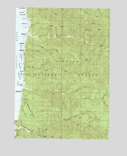
Heceta Head, OR USGS Topographic Map
Click on map above to begin viewing in our Map Viewer.

This topographic map contains these locations and features:
Feature Name Type Latitude Longitude GNIS ID View Map
Agate CreekStreamN44.2348°W124.1096°1137027View Map
Big CreekStreamN44.1765°W124.1148°1138006View Map
Big Creek Forest Camp (historical)LocaleN44.1679°W124.0040°1138010View Map
Blowout CreekStreamN44.1571°W124.1179°1138282View Map
Blue RidgeRidgeN44.1446°W124.0351°1138327View Map
Bob CreekStreamN44.2440°W124.1118°1138366View Map
Bray PointCapeN44.2390°W124.1107°1138584View Map
Cape CreekStreamN44.1343°W124.1237°1118593View Map
Cape Creek Tunnel 3961TunnelN44.1319°W124.1223°2668620View Map
Carl G Washburne Memorial State ParkParkN44.1582°W124.1165°1162413View Map
China CreekStreamN44.1693°W124.1160°1139668View Map
Cummins RidgeRidgeN44.2457°W124.0393°1140551View Map
Devils ElbowBayN44.1321°W124.1246°1140948View Map
Fairview MountainSummitN44.1999°W124.0343°1141952View Map
Florence DivisionCivilN44.1475°W124.0232°1938079View Map
Fryingpan CreekStreamN44.1657°W124.0496°1142522View Map
Gwynn KnollSummitN44.2460°W124.1147°1143173View Map
Heceta Head LighthouseBuildingN44.1365°W124.1249°2699979View Map
Heceta Head Lighthouse State Scenic ViewpointParkN44.1387°W124.1196°1140949View Map
Heceta Post Office (historical)Post OfficeN44.1335°W124.1221°1164402View Map
Lanham Bike Recreation Site (historical)LocaleN44.1860°W124.1143°1167057View Map
Mill CreekStreamN44.2229°W124.1082°1146226View Map
Minnie Post Office (historical)Post OfficeN44.2243°W124.1096°1164518View Map
Muriel O Ponsler Memorial State Scenic ViewpointParkN44.1707°W124.1154°1147873View Map
Nancy CreekStreamN44.1932°W124.1140°1146724View Map
North Fork Cape CreekStreamN44.1418°W124.0576°1146919View Map
North Fork QuarryMineN44.1429°W124.0568°1159250View Map
Ocean Beach Recreation SiteLocaleN44.1879°W124.1137°1147136View Map
Panther CreekStreamN44.1632°W124.0109°1154790View Map
Rock CreekStreamN44.1829°W124.1148°1148564View Map
Rock Creek Recreation SiteLocaleN44.1857°W124.1096°1148604View Map
Rock Creek WildernessReserveN44.1832°W124.0462°1987626View Map
Rocky KnollSummitN44.1861°W124.1159°1148665View Map
Roosevelt BeachPopulated PlaceN44.1748°W124.1140°1148713View Map
Roosevelt Beach Post Office (historical)Post OfficeN44.1748°W124.1140°1165880View Map
Searose BeachPopulated PlaceN44.2323°W124.1085°1149196View Map
Stonefield Beach BurialsCemeteryN44.2235°W124.1108°2768066View Map
Stonefield Beach State Recreation SiteParkN44.2248°W124.1118°1159249View Map
Ten Mile Creek Recreation Site (historical)LocaleN44.2137°W124.0090°1150975View Map
Tenmile CreekStreamN44.2254°W124.1110°1150974View Map
Tenmile RidgeRidgeN44.2296°W124.0162°1150977View Map
Tokatee CreekStreamN44.2076°W124.1157°1150232View Map
Tokatee Kloochman State Natural SiteParkN44.2082°W124.1151°1162414View Map
Wapiti CreekStreamN44.1293°W124.0951°1151881View Map

Note: Coordinates in the location and feature list above are referenced to NAD83 datum.


Copyright (C) 2008-2024 Ryan Niemi / Sunset Dynamics ... All Rights Reserved