TopoQuest Logo
Do you find TopoQuest useful?
Help keep TopoQuest running and adding new maps/features by donating!
Bitcoin:  19c7KJd3qBynnjoSw5npx9KScwjBe4ifkT
Litecoin:  LXs6TkuXGGXo1vDsWCkWVdjQX94eUKd6ui
Home View Maps Find Maps Find Places Resources & Links


Henderson Bay, New York Topographic Map

USGS Map Title: Henderson Bay, NY
USGS Map MRC: 43076H2
DRG (GeoTIFF) Download: o43076h2.tif


Neighboring USGS Topographic Map Quads:


  Cape Vincent South, NY  
44076A3
 

  Chaumont, NY  
44076A2
 

  Dexter, NY  
44076A1
 

  Point Peninsula, NY  
43076H3
 

  Henderson Bay, NY  
43076H2
 

  Sackets Harbor, NY  
43076H1
 

  Stony Point, NY  
43076G3
 

  Henderson, NY  
43076G2
 

  Adams, NY  
43076G1


Map MRC Location:

N44°
W77°
N44°
W76°
H8 H7 H6 H5 H4 H3 H2 H1
G8 G7 G6 G5 G4 G3 G2 G1
F8 F7 F6 F5 F4 F3 F2 F1
E8 E7 E6 E5 E4 E3 E2 E1
D8 D7 D6 D5 D4 D3 D2 D1
C8 C7 C6 C5 C4 C3 C2 C1
B8 B7 B6 B5 B4 B3 B2 B1
A8 A7 A6 A5 A4 A3 A2 A1
N43°
W77°
N43°
W76°

Henderson Bay, NY USGS 1:24K Topographic Map Preview:
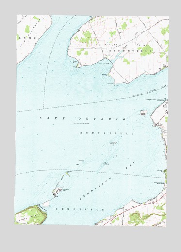
Henderson Bay, NY USGS Topographic Map
Click on map above to begin viewing in our Map Viewer.

This topographic map contains these locations and features:
Feature Name Type Latitude Longitude GNIS ID View Map
Association IslandIslandN43.8953°W76.2146°942652View Map
Bass IslandIslandN43.9242°W76.1680°943142View Map
Bedford CreekStreamN43.9106°W76.1252°943490View Map
Boultons BeachPopulated PlaceN43.9356°W76.1344°944495View Map
Bull Rock PointCapeN43.9653°W76.1733°945134View Map
Campbell PointCapeN43.9078°W76.1277°945708View Map
Dexter Volunteer Fire Department Pillar Point Station 2BuildingN43.9918°W76.1427°2718258View Map
Everleigh PointCapeN43.9598°W76.1685°949778View Map
Ferry CemeteryCemeteryN43.9721°W76.1251°950008View Map
Gilmore PointCapeN43.9403°W76.1396°971976View Map
Gilmore ShoreBeachN43.9420°W76.1410°973903View Map
Gull IslandIslandN43.9120°W76.1763°951930View Map
Henderson BayBayN43.8955°W76.1766°974218View Map
Horse IslandIslandN43.9426°W76.1446°953227View Map
Hoveys IslandIslandN43.8876°W76.2238°973328View Map
Ingalls - Ingerson CemeteryCemeteryN43.9898°W76.1657°953717View Map
Lime Barrel ShoalBarN43.9128°W76.1916°955334View Map
Madison Barracks Pumping StationLocaleN43.9356°W76.1358°2105959View Map
Marsh PointCapeN43.9989°W76.1880°956559View Map
Pillar PointCapeN43.9695°W76.1996°960400View Map
Pillar PointCapeN43.9823°W76.1813°960401View Map
Pillar PointPopulated PlaceN43.9703°W76.1258°960402View Map
Reeds BayBayN43.9720°W76.2010°962352View Map
Sackets Harbor Battlefield State ParkParkN43.9495°W76.1263°963167View Map
Sackets Harbor LighthouseLocaleN43.9428°W76.1447°2105960View Map
Sackets Harbor Police DepartmentBuildingN43.9480°W76.1254°2780360View Map
Sackets Harbor Sewage Treatment PlantLocaleN43.9459°W76.1283°2617754View Map
School Number 11 (historical)SchoolN43.9694°W76.1261°2105962View Map
School Number 12 (historical)SchoolN43.9800°W76.1850°2105963View Map
School Number 5 (historical)SchoolN43.9917°W76.1425°2105961View Map
Sherwin BayBayN43.9715°W76.1756°965092View Map
Sherwin Bay CemeteryCemeteryN43.9768°W76.1773°965093View Map
Sherwin CreekStreamN43.9731°W76.1730°965094View Map
Six Town PointCapeN43.9064°W76.2069°965320View Map
Snowshoe BayBayN43.8848°W76.2260°965584View Map
South Shore School (historical)SchoolN43.9722°W76.2450°2105964View Map
Stone CemeteryCemeteryN43.9686°W76.1300°966491View Map
The Willows ParkParkN43.8915°W76.1291°973902View Map
Town of HounsfieldCivilN43.9241°W76.2080°979081View Map

Note: Coordinates in the location and feature list above are referenced to NAD83 datum.


Copyright (C) 2008-2024 Ryan Niemi / Sunset Dynamics ... All Rights Reserved