TopoQuest Logo
Do you find TopoQuest useful?
Help keep TopoQuest running and adding new maps/features by donating!
Bitcoin:  19c7KJd3qBynnjoSw5npx9KScwjBe4ifkT
Litecoin:  LXs6TkuXGGXo1vDsWCkWVdjQX94eUKd6ui
Home View Maps Find Maps Find Places Resources & Links


Hendrickson, Missouri Topographic Map

USGS Map Title: Hendrickson, MO
USGS Map MRC: 36090H4
DRG (GeoTIFF) Download: o36090h4.tif


Neighboring USGS Topographic Map Quads:


  Piedmont SE, MO  
37090A5
 

  Greenville SW, MO  
37090A4
 

  Shook, MO  
37090A3
 

  Williamsville, MO  
36090H5
 

  Hendrickson, MO  
36090H4
 

  Wappapello, MO  
36090H3
 

  Stringtown, MO  
36090G5
 

  Poplar Bluff, MO  
36090G4
 

  Rombauer, MO  
36090G3


Map MRC Location:

N37°
W91°
N37°
W90°
H8 H7 H6 H5 H4 H3 H2 H1
G8 G7 G6 G5 G4 G3 G2 G1
F8 F7 F6 F5 F4 F3 F2 F1
E8 E7 E6 E5 E4 E3 E2 E1
D8 D7 D6 D5 D4 D3 D2 D1
C8 C7 C6 C5 C4 C3 C2 C1
B8 B7 B6 B5 B4 B3 B2 B1
A8 A7 A6 A5 A4 A3 A2 A1
N36°
W91°
N36°
W90°

Hendrickson, MO USGS 1:24K Topographic Map Preview:
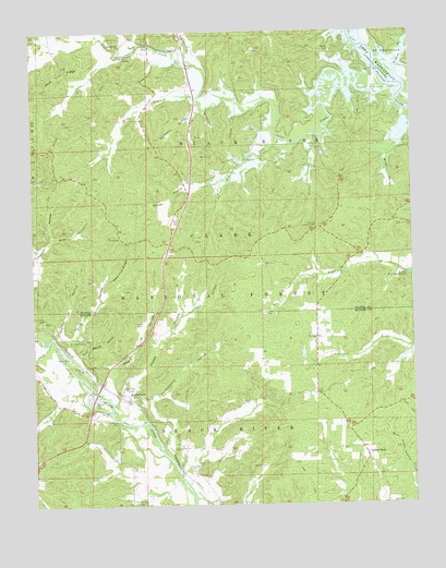
Hendrickson, MO USGS Topographic Map
Click on map above to begin viewing in our Map Viewer.

This topographic map contains these locations and features:
Feature Name Type Latitude Longitude GNIS ID View Map
Allison School (historical)SchoolN36.9401°W90.4423°730496View Map
Asher Creek School (historical)SchoolN36.9412°W90.3943°747589View Map
Asher Creek ValleyValleyN36.9278°W90.4207°730498View Map
Barrett MineMineN36.9931°W90.4696°730495View Map
Barrett Switch (historical)LocaleN36.9956°W90.4929°747586View Map
Bear HollowValleyN36.9459°W90.4932°748735View Map
Bethel CemeteryCemeteryN36.9950°W90.4012°748802View Map
Bethel Church (historical)ChurchN36.9951°W90.4007°730491View Map
Bethel School (historical)SchoolN36.9948°W90.4018°747588View Map
Bluewater SchoolSchoolN36.9109°W90.3887°747590View Map
Butler County Fire Protection District Hendrickson StationBuildingN36.8846°W90.4991°2620721View Map
Chaonia Landing Launching RampLocaleN36.9831°W90.3940°754955View Map
Chaonia Volunteer Fire DepartmentBuildingN36.9500°W90.3794°2621408View Map
Collins StoreLocaleN36.8881°W90.3909°749431View Map
Cool Spring CemeteryCemeteryN36.9959°W90.4657°730494View Map
Cool Springs ChurchChurchN36.9962°W90.4707°749459View Map
Cool Springs School (historical)SchoolN36.9959°W90.4712°730497View Map
Davidson CemeteryCemeteryN36.8850°W90.4501°749571View Map
Davidson School (historical)SchoolN36.8867°W90.4396°747591View Map
Davidsons Mill (historical)LocaleN36.8803°W90.4507°735263View Map
Deer Lick RidgeRidgeN36.9895°W90.4901°749609View Map
Elston DamDamN36.9151°W90.4134°764715View Map
Elston LakeReservoirN36.9149°W90.4113°764716View Map
Flatwoods Lookout TowerTowerN36.9489°W90.4059°755180View Map
Fox Den MineMineN36.9951°W90.4265°753951View Map
Garver LakeReservoirN36.9138°W90.3779°764998View Map
Garver Lake DamDamN36.9151°W90.3768°764997View Map
Goldbeck HollowValleyN36.9798°W90.4451°750064View Map
Happy HollowValleyN36.9034°W90.4679°750220View Map
Harwell CemeteryCemeteryN36.8853°W90.4290°750249View Map
Heather HollowValleyN36.9198°W90.4890°750275View Map
HendricksonPopulated PlaceN36.9045°W90.4690°750291View Map
Hockinberry HollowValleyN36.8912°W90.4573°750345View Map
Kecher Gravel PitsMineN36.9048°W90.4818°735261View Map
Kechers FerryLocaleN36.9053°W90.4798°735262View Map
Keele CemeteryCemeteryN36.9234°W90.4665°750562View Map
LaderoPopulated PlaceN36.9959°W90.4701°739858View Map
Link HollowValleyN36.9173°W90.4879°750727View Map
Magill CemeteryCemeteryN36.9064°W90.4712°750905View Map
Magill FerryLocaleN36.8973°W90.4704°735260View Map
Magill HollowValleyN36.9067°W90.4754°750906View Map
Milan HollowValleyN36.9767°W90.3762°751053View Map
Military Crossing CemeteryCemeteryN36.9184°W90.4890°751055View Map
Mink CreekStreamN36.9726°W90.4076°751121View Map
Mount Zion CemeteryCemeteryN36.9195°W90.4074°2681361View Map
Mount Zion ChurchChurchN36.9192°W90.4073°751205View Map
Ojibway (historical)LocaleN36.9734°W90.4090°747584View Map
Otter CreekStreamN36.9842°W90.3804°751455View Map
Perkins BranchStreamN36.9901°W90.3793°751547View Map
Pink Root HollowValleyN36.9898°W90.3959°730492View Map
Pleasant Hill Church (historical)ChurchN36.9451°W90.4709°730493View Map
Pleasant Hill School (historical)SchoolN36.9414°W90.4690°747587View Map
Porter DamDamN36.9551°W90.4551°764031View Map
Porter LakeReservoirN36.9551°W90.4545°764032View Map
Powers CreekStreamN36.8834°W90.4521°735259View Map
Pryor Spring HollowValleyN36.9148°W90.4848°751771View Map
Rucker CemeteryCemeteryN36.9673°W90.4401°751980View Map
Rucker Church (historical)ChurchN36.9670°W90.4396°730490View Map
Rucker School (historical)SchoolN36.9667°W90.4332°747585View Map
Seed Tick RidgeRidgeN36.9378°W90.4701°752073View Map
Smith CemeteryCemeteryN36.9456°W90.4712°753953View Map
Smoot HollowValleyN36.9956°W90.4484°752230View Map
Stillhouse HollowValleyN36.9789°W90.4432°752368View Map
Swift CreekStreamN36.9187°W90.4951°752468View Map
Taskee ChurchChurchN36.9959°W90.4515°752492View Map
Taskee Station (historical)Populated PlaceN36.9926°W90.4504°739853View Map
Taylor MillLocaleN36.9726°W90.4079°730489View Map
Three Springs CemeteryCemeteryN36.8751°W90.4659°752541View Map
Township of Black RiverCivilN36.9747°W90.4240°767517View Map
Township of Black RiverCivilN36.8842°W90.4417°766350View Map
Walker HollowValleyN36.9592°W90.4484°752732View Map
Wet ForkStreamN36.9701°W90.4150°752834View Map
Wilsons SwitchLocaleN36.9862°W90.3859°740103View Map
Wolf HollowValleyN36.9256°W90.4501°752951View Map
Wolf RunStreamN36.9828°W90.4454°752960View Map
Woolard CemeteryCemeteryN36.9675°W90.4182°752977View Map

Note: Coordinates in the location and feature list above are referenced to NAD83 datum.


Copyright (C) 2008-2025 Ryan Niemi / Sunset Dynamics ... All Rights Reserved