TopoQuest Logo
Do you find TopoQuest useful?
Help keep TopoQuest running and adding new maps/features by donating!
Bitcoin:  19c7KJd3qBynnjoSw5npx9KScwjBe4ifkT
Litecoin:  LXs6TkuXGGXo1vDsWCkWVdjQX94eUKd6ui
Home View Maps Find Maps Find Places Resources & Links


Poplar Bluff, Missouri Topographic Map

USGS Map Title: Poplar Bluff, MO
USGS Map MRC: 36090G4
DRG (GeoTIFF) Download: o36090g4.tif


Neighboring USGS Topographic Map Quads:


  Williamsville, MO  
36090H5
 

  Hendrickson, MO  
36090H4
 

  Wappapello, MO  
36090H3
 

  Stringtown, MO  
36090G5
 

  Poplar Bluff, MO  
36090G4
 

  Rombauer, MO  
36090G3
 

  Fairdealing, MO  
36090F5
 

  Harviell, MO  
36090F4
 

  Hanleyville, MO  
36090F3


Map MRC Location:

N37°
W91°
N37°
W90°
H8 H7 H6 H5 H4 H3 H2 H1
G8 G7 G6 G5 G4 G3 G2 G1
F8 F7 F6 F5 F4 F3 F2 F1
E8 E7 E6 E5 E4 E3 E2 E1
D8 D7 D6 D5 D4 D3 D2 D1
C8 C7 C6 C5 C4 C3 C2 C1
B8 B7 B6 B5 B4 B3 B2 B1
A8 A7 A6 A5 A4 A3 A2 A1
N36°
W91°
N36°
W90°

Poplar Bluff, MO USGS 1:24K Topographic Map Preview:
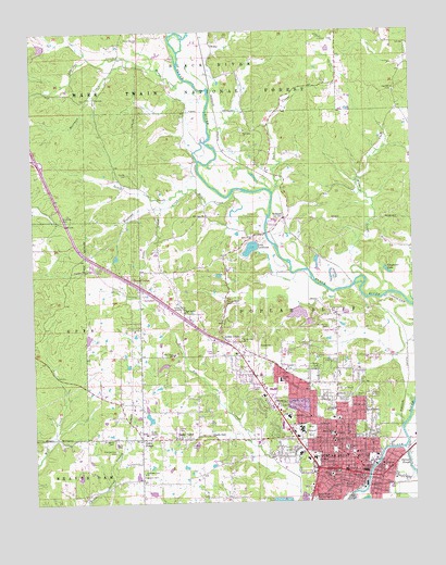
Poplar Bluff, MO USGS Topographic Map
Click on map above to begin viewing in our Map Viewer.

This topographic map contains these locations and features:
Feature Name Type Latitude Longitude GNIS ID View Map
Agee ChurchChurchN36.8203°W90.4282°748562View Map
Agee ChurchChurchN36.8262°W90.4429°748563View Map
Agee CreekStreamN36.8312°W90.4337°735272View Map
Aldridge CreekStreamN36.8678°W90.4671°748566View Map
Bacon Memorial ParkParkN36.7681°W90.4096°748635View Map
Big LakeReservoirN36.8017°W90.4134°764981View Map
Black Creek SchoolSchoolN36.7564°W90.4698°747599View Map
Black River SeminarySchoolN36.7623°W90.3957°735280View Map
Buck CreekStreamN36.8323°W90.4207°749081View Map
Butler County Fire Protection District Oakbrier StationBuildingN36.8613°W90.3909°2620723View Map
Butler County Fire Protection District PP Highway StationBuildingN36.7690°W90.4535°2620716View Map
Butler County Sheriff's OfficeBuildingN36.7571°W90.3925°2752248View Map
Carpenter LakeLakeN36.8110°W90.3834°749219View Map
Cedar ValleyPopulated PlaceN36.7670°W90.4532°749312View Map
Chamberlain DamDamN36.7717°W90.4618°764167View Map
Chamberlain LakeReservoirN36.7724°W90.4624°764168View Map
City of Poplar BluffCivilN36.7632°W90.4135°2396252View Map
Dobbs CreekStreamN36.8281°W90.4573°749668View Map
First Baptist ChurchChurchN36.7653°W90.3962°735279View Map
Green ForestPopulated PlaceN36.7670°W90.4651°750136View Map
Green Forest ChurchChurchN36.7664°W90.4654°754393View Map
Hartman CreekStreamN36.8684°W90.4673°750247View Map
Harwell CreekStreamN36.8062°W90.4032°735278View Map
Hewlett Lake DamDamN36.7651°W90.4468°765595View Map
Hickory CreekStreamN36.8092°W90.3921°750304View Map
Hillcrest ParkParkN36.7612°W90.3896°750331View Map
HilliardPopulated PlaceN36.8253°W90.4168°750334View Map
Hoedapp CreekStreamN36.8323°W90.4493°750352View Map
Hon-Dah ReservoirReservoirN36.8714°W90.4965°764170View Map
Hudgens CemeteryCemeteryN36.7670°W90.4746°750412View Map
Indian CreekStreamN36.8028°W90.3751°750450View Map
John J Pershing Veterans Affairs Medical CenterHospitalN36.7725°W90.4167°2655024View Map
Kelley LakeReservoirN36.7526°W90.4618°764723View Map
Kelley Lake DamDamN36.7517°W90.4618°764722View Map
Kelly TownPopulated PlaceN36.7506°W90.4026°735298View Map
Kinyon SchoolSchoolN36.7570°W90.4032°750622View Map
KOKS-FM (Poplar Bluff)TowerN36.8112°W90.4640°759020View Map
KPOB-TV (Poplar Bluff)TowerN36.8006°W90.4509°759306View Map
KWOC-FM (Poplar Bluff)TowerN36.7628°W90.4343°759068View Map
KXOQ-FM (Poplar Bluff)TowerN36.7664°W90.4812°754236View Map
Lake LocklomaReservoirN36.8173°W90.4283°758305View Map
Lake Lockloma DamDamN36.8167°W90.4268°763940View Map
Lake Shore Acres DamDamN36.7867°W90.4568°764728View Map
Lewis CreekStreamN36.8320°W90.4490°750689View Map
Line ParkParkN36.7584°W90.3854°750725View Map
Loma LindaPopulated PlaceN36.7934°W90.4371°750827View Map
Lucy Lee Hospital HeliportAirportN36.7906°W90.4318°758876View Map
Mansion MallLocaleN36.7587°W90.4079°753115View Map
Marble Hill CemeteryCemeteryN36.7966°W90.4019°750926View Map
Marble Hill School (historical)SchoolN36.7956°W90.4009°747604View Map
Mark Twain National Forest Poplar BluffBuildingN36.7627°W90.4102°2621327View Map
Mark Twain SchoolSchoolN36.7678°W90.4021°750934View Map
Martin School (historical)SchoolN36.8720°W90.3843°747601View Map
Mason Memorial DamDamN36.8717°W90.4951°764169View Map
Mengo (historical)LocaleN36.7962°W90.3796°747603View Map
Mengo BridgeBridgeN36.8073°W90.3948°747602View Map
Mengo SloughGutN36.7978°W90.3796°739859View Map
Mill CreekStreamN36.8320°W90.4342°751060View Map
Missouri Department of Conservation Forestry Southeast Regional Field Fire Office Poplar BluffBuildingN36.8011°W90.4576°2620737View Map
Missouri State Highway Patrol Troop EBuildingN36.8093°W90.4714°2752594View Map
Mononame 646 DamDamN36.7501°W90.4584°764721View Map
Mononame 667 DamDamN36.7817°W90.4568°764727View Map
Montgomery CemeteryCemeteryN36.7640°W90.4738°751141View Map
Mount Olive ChurchChurchN36.7559°W90.3865°735277View Map
North Side ChurchChurchN36.7928°W90.4318°751358View Map
Nunley CemeteryCemeteryN36.8373°W90.4684°751365View Map
O'Neal SchoolSchoolN36.7826°W90.4193°751367View Map
Oak Brier Estates DamDamN36.8634°W90.3834°764984View Map
Oak Grove ChurchChurchN36.8006°W90.4501°751376View Map
Oak Grove SchoolSchoolN36.7892°W90.4540°751380View Map
Oak Hill CemeteryCemeteryN36.8492°W90.4307°735273View Map
Oak Hill ChurchChurchN36.8487°W90.4296°751386View Map
Oak Hill ChurchChurchN36.8589°W90.3804°751387View Map
Oak Hill SchoolSchoolN36.8489°W90.4268°747598View Map
Oak Lookout TowerTowerN36.8734°W90.4048°755347View Map
Old Mark Twain SchoolSchoolN36.7656°W90.4018°751420View Map
Palmer SloughLakeN36.7566°W90.3751°751479View Map
Pike Creek Church (historical)ChurchN36.7548°W90.4359°747600View Map
Poplar BluffPopulated PlaceN36.7570°W90.3929°751712View Map
Poplar Bluff Country ClubLocaleN36.8031°W90.4365°755368View Map
Poplar Bluff Fire Department Station 1BuildingN36.7545°W90.3940°2621049View Map
Poplar Bluff Fire Department Station 2BuildingN36.7932°W90.4348°2621637View Map
Poplar Bluff Police DepartmentBuildingN36.7568°W90.4067°2752540View Map
Poplar Bluff Post OfficePost OfficeN36.7556°W90.3955°2779474View Map
Poplar Bluff Regional Medical Center - WestwoodHospitalN36.7855°W90.4265°2655105View Map
Poplar Bluff Regional Medical Center SouthHospitalN36.7581°W90.3973°2655106View Map
Rolling Hills Estates LakeReservoirN36.7534°W90.4851°765582View Map
Rolling Hills Estates Lake DamDamN36.7534°W90.4851°765581View Map
Sacred Heart Catholic CemeteryCemeteryN36.7506°W90.4087°751996View Map
Sacred Heart ChurchChurchN36.7581°W90.4004°735276View Map
Sacred Heart SchoolSchoolN36.7576°W90.4004°751997View Map
Second Baptist ChurchChurchN36.7584°W90.3954°735275View Map
Shadle CemeteryCemeteryN36.7653°W90.4493°752086View Map
Shady DellPopulated PlaceN36.7678°W90.4421°752087View Map
Sheppard CemeteryCemeteryN36.7575°W90.4648°752111View Map
Shipman FordLocaleN36.8214°W90.4232°735274View Map
Shore Acres LakeReservoirN36.7863°W90.4577°764729View Map
Smith SchoolSchoolN36.7595°W90.3859°752225View Map
Tamaro Oaks DamDamN36.8017°W90.4134°764980View Map
Temple ChurchChurchN36.7851°W90.4173°752509View Map
Three Springs SchoolSchoolN36.8717°W90.4734°747597View Map
Township Line ChurchChurchN36.7578°W90.4646°752569View Map
Wheatley SchoolSchoolN36.7642°W90.3976°752842View Map
Widow CreekStreamN36.8623°W90.4496°752879View Map
WilbyPopulated PlaceN36.8709°W90.4398°752883View Map
Woodlawn CemeteryCemeteryN36.7767°W90.3984°752968View Map
Wren LakeReservoirN36.7999°W90.4131°764983View Map
Wren Lake DamDamN36.7984°W90.4101°764982View Map

Note: Coordinates in the location and feature list above are referenced to NAD83 datum.


Copyright (C) 2008-2025 Ryan Niemi / Sunset Dynamics ... All Rights Reserved