TopoQuest Logo
Do you find TopoQuest useful?
Help keep TopoQuest running and adding new maps/features by donating!
Bitcoin:  19c7KJd3qBynnjoSw5npx9KScwjBe4ifkT
Litecoin:  LXs6TkuXGGXo1vDsWCkWVdjQX94eUKd6ui
Home View Maps Find Maps Find Places Resources & Links


Hensonville, New York Topographic Map

USGS Map Title: Hensonville, NY
USGS Map MRC: 42074C2
DRG (GeoTIFF) Download: o42074c2.tif


Neighboring USGS Topographic Map Quads:


  Livingstonville, NY  
42074D3
 

  Durham, NY  
42074D2
 

  Greenville, NY  
42074D1
 

  Ashland, NY  
42074C3
 

  Hensonville, NY  
42074C2
 

  Freehold, NY  
42074C1
 

  Lexington, NY  
42074B3
 

  Hunter, NY  
42074B2
 

  Kaaterskill Clove, NY  
42074B1


Map MRC Location:

N43°
W75°
N43°
W74°
H8 H7 H6 H5 H4 H3 H2 H1
G8 G7 G6 G5 G4 G3 G2 G1
F8 F7 F6 F5 F4 F3 F2 F1
E8 E7 E6 E5 E4 E3 E2 E1
D8 D7 D6 D5 D4 D3 D2 D1
C8 C7 C6 C5 C4 C3 C2 C1
B8 B7 B6 B5 B4 B3 B2 B1
A8 A7 A6 A5 A4 A3 A2 A1
N42°
W75°
N42°
W74°

Hensonville, NY USGS 1:24K Topographic Map Preview:
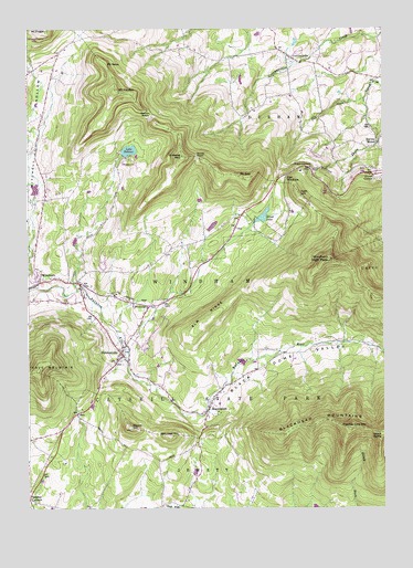
Hensonville, NY USGS Topographic Map
Click on map above to begin viewing in our Map Viewer.

This topographic map contains these locations and features:
Feature Name Type Latitude Longitude GNIS ID View Map
Barlow NotchGapN42.3529°W74.2068°943021View Map
Beecher CornersLocaleN42.2526°W74.2499°969870View Map
Black Dome ValleyValleyN42.2959°W74.2168°944131View Map
Blackhead MountainsRangeN42.2712°W74.1501°944200View Map
BrooksburgPopulated PlaceN42.3029°W74.2068°944865View Map
Catskill MountainsRangeN42.2504°W74.2499°969309View Map
Cave MountainSummitN42.2859°W74.2463°946079View Map
CornwallvillePopulated PlaceN42.3681°W74.1582°947485View Map
Cornwallville CemeteryCemeteryN42.3672°W74.1572°2547526View Map
Cornwallville Methodist Episcopal Church (historical)ChurchN42.3672°W74.1572°2547527View Map
Durso CornerPopulated PlaceN42.3368°W74.1282°948842View Map
East WindhamPopulated PlaceN42.3368°W74.1590°949278View Map
Elm RidgeRidgeN42.3004°W74.1879°949553View Map
Fall CreekStreamN42.3567°W74.1310°949877View Map
Free Methodist ChurchChurchN42.2774°W74.1853°2616040View Map
Ginseng MountainSummitN42.3415°W74.1957°951143View Map
HensonvillePopulated PlaceN42.2898°W74.2165°952612View Map
Hensonville CemeteryCemeteryN42.2906°W74.2159°2547559View Map
Hervey StreetPopulated PlaceN42.3451°W74.1265°952646View Map
Jennie NotchGapN42.3418°W74.1907°953991View Map
Kate HillSummitN42.3320°W74.1546°954394View Map
Lake HeloiseLakeN42.3435°W74.2140°952552View Map
MaplecrestPopulated PlaceN42.2759°W74.1868°956456View Map
Maplecrest CemeteryCemeteryN42.2784°W74.1852°2547558View Map
Mill Family CemeteryCemeteryN42.2500°W74.2087°2547543View Map
Mitchell Hollow Mission ChurchChurchN42.3528°W74.2457°2616727View Map
Mount HaydenSummitN42.3587°W74.2190°952442View Map
Mount NeboSummitN42.3659°W74.2218°958319View Map
Mount ZoarSummitN42.3365°W74.1738°971889View Map
Peter Van Orden Rural CemeteryCemeteryN42.3260°W74.1752°2547562View Map
Point LookoutCapeN42.3398°W74.1529°960825View Map
Round HillSummitN42.2709°W74.2138°962965View Map
Saint Theresa's ChurchChurchN42.3104°W74.2388°2617037View Map
Silver LakeLakeN42.3261°W74.1670°965258View Map
Thomas Cole MountainSummitN42.2709°W74.1365°973362View Map
Town of WindhamCivilN42.3147°W74.2086°979648View Map
Union Society CemeteryCemeteryN42.3160°W74.2018°2547561View Map
Van Loan HillSummitN42.2690°W74.2001°968422View Map
Windham CemeteryCemeteryN42.3097°W74.2446°2547560View Map
Windham Census Designated PlaceCensusN42.3150°W74.2482°2390523View Map
Windham High PeakSummitN42.3148°W74.1435°971464View Map

Note: Coordinates in the location and feature list above are referenced to NAD83 datum.


Copyright (C) 2008-2024 Ryan Niemi / Sunset Dynamics ... All Rights Reserved