TopoQuest Logo
Do you find TopoQuest useful?
Help keep TopoQuest running and adding new maps/features by donating!
Bitcoin:  19c7KJd3qBynnjoSw5npx9KScwjBe4ifkT
Litecoin:  LXs6TkuXGGXo1vDsWCkWVdjQX94eUKd6ui
Home View Maps Find Maps Find Places Resources & Links


Higdon, Missouri Topographic Map

USGS Map Title: Higdon, MO
USGS Map MRC: 37090E2
DRG (GeoTIFF) Download: o37090e2.tif


Neighboring USGS Topographic Map Quads:


  Knob Lick, MO  
37090F3
 

  Womack, MO  
37090F2
 

  Parker Lake, MO  
37090F1
 

  Fredericktown, MO  
37090E3
 

  Higdon, MO  
37090E2
 

  Patton, MO  
37090E1
 

  Cherokee Pass, MO  
37090D3
 

  Marquand, MO  
37090D2
 

  Hurricane, MO  
37090D1


Map MRC Location:

N38°
W91°
N38°
W90°
H8 H7 H6 H5 H4 H3 H2 H1
G8 G7 G6 G5 G4 G3 G2 G1
F8 F7 F6 F5 F4 F3 F2 F1
E8 E7 E6 E5 E4 E3 E2 E1
D8 D7 D6 D5 D4 D3 D2 D1
C8 C7 C6 C5 C4 C3 C2 C1
B8 B7 B6 B5 B4 B3 B2 B1
A8 A7 A6 A5 A4 A3 A2 A1
N37°
W91°
N37°
W90°

Higdon, MO USGS 1:24K Topographic Map Preview:
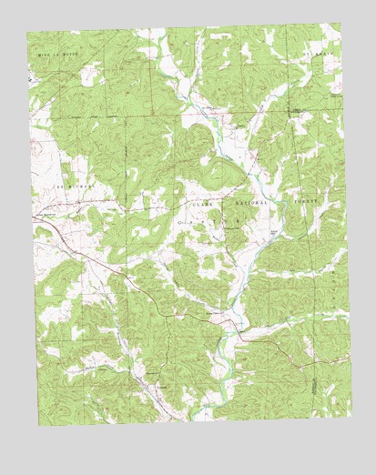
Higdon, MO USGS Topographic Map
Click on map above to begin viewing in our Map Viewer.

This topographic map contains these locations and features:
Feature Name Type Latitude Longitude GNIS ID View Map
Campbell SchoolSchoolN37.5445°W90.2279°748153View Map
Cape CreekStreamN37.5281°W90.1701°749203View Map
Castor StationPopulated PlaceN37.5278°W90.1696°737873View Map
Church of Jesus ChristChurchN37.6028°W90.1298°749356View Map
Combs BranchStreamN37.5473°W90.1640°749435View Map
CornwallPopulated PlaceN37.5123°W90.2029°749480View Map
Cornwall ChurchChurchN37.5159°W90.2012°749481View Map
Dry BranchStreamN37.5801°W90.1651°749700View Map
East Madison SchoolSchoolN37.5670°W90.2476°749781View Map
Hackle CreekStreamN37.5164°W90.2126°750183View Map
Hahns MillPopulated PlaceN37.5587°W90.1551°750188View Map
HigdonPopulated PlaceN37.5928°W90.1679°750314View Map
Mine LaMotteMineN37.6098°W90.2493°751112View Map
Mount Gilead ChurchChurchN37.5989°W90.1765°751178View Map
Peterman CemeteryCemeteryN37.5453°W90.2309°751567View Map
Phillips AirportAirportN37.5719°W90.2266°2679335View Map
Southeastern OzarksAreaN37.5003°W90.1254°754114View Map
Spring Valley CemeteryCemeteryN37.5303°W90.1709°752322View Map
Spring Valley ChurchChurchN37.5345°W90.1751°752324View Map
Spring Valley CreekStreamN37.5356°W90.1712°752325View Map
Spring Valley SchoolSchoolN37.5234°W90.1704°748154View Map
Stannett CreekStreamN37.5581°W90.1523°727009View Map
Township of CastorCivilN37.5496°W90.1910°766983View Map
Tucker CreekStreamN37.5406°W90.1684°752588View Map
Turkey CreekStreamN37.6005°W90.1849°752602View Map
Underwood CemeteryCemeteryN37.5564°W90.1768°752650View Map
Underwood SchoolSchoolN37.5609°W90.1740°752651View Map

Note: Coordinates in the location and feature list above are referenced to NAD83 datum.


Copyright (C) 2008-2024 Ryan Niemi / Sunset Dynamics ... All Rights Reserved