TopoQuest Logo
Do you find TopoQuest useful?
Help keep TopoQuest running and adding new maps/features by donating!
Bitcoin:  19c7KJd3qBynnjoSw5npx9KScwjBe4ifkT
Litecoin:  LXs6TkuXGGXo1vDsWCkWVdjQX94eUKd6ui
Home View Maps Find Maps Find Places Resources & Links


Cherokee Pass, Missouri Topographic Map

USGS Map Title: Cherokee Pass, MO
USGS Map MRC: 37090D3
DRG (GeoTIFF) Download: o37090d3.tif


Neighboring USGS Topographic Map Quads:


  Rhodes Mountain, MO  
37090E4
 

  Fredericktown, MO  
37090E3
 

  Higdon, MO  
37090E2
 

  Rock Pile Mountain, MO  
37090D4
 

  Cherokee Pass, MO  
37090D3
 

  Marquand, MO  
37090D2
 

  Coldwater, MO  
37090C4
 

  Cascade, MO  
37090C3
 

  Allbright, MO  
37090C2


Map MRC Location:

N38°
W91°
N38°
W90°
H8 H7 H6 H5 H4 H3 H2 H1
G8 G7 G6 G5 G4 G3 G2 G1
F8 F7 F6 F5 F4 F3 F2 F1
E8 E7 E6 E5 E4 E3 E2 E1
D8 D7 D6 D5 D4 D3 D2 D1
C8 C7 C6 C5 C4 C3 C2 C1
B8 B7 B6 B5 B4 B3 B2 B1
A8 A7 A6 A5 A4 A3 A2 A1
N37°
W91°
N37°
W90°

Cherokee Pass, MO USGS 1:24K Topographic Map Preview:
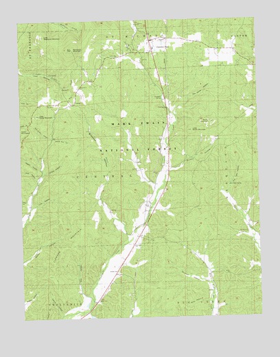
Cherokee Pass, MO USGS Topographic Map
Click on map above to begin viewing in our Map Viewer.

This topographic map contains these locations and features:
Feature Name Type Latitude Longitude GNIS ID View Map
Altar HollowValleyN37.4323°W90.3657°753532View Map
Antioch CemeteryCemeteryN37.4362°W90.3029°753534View Map
Antioch Church (historical)ChurchN37.4359°W90.3029°748603View Map
Barber CemeteryCemeteryN37.4220°W90.3076°753535View Map
Bremser HollowValleyN37.4070°W90.3193°753529View Map
Burnley CemeteryCemeteryN37.4106°W90.2562°753539View Map
Burns MountainSummitN37.4567°W90.2751°749127View Map
Buzzard HollowValleyN37.3895°W90.2762°753545View Map
CentralPopulated PlaceN37.4651°W90.3468°753521View Map
Central ChurchChurchN37.4723°W90.3426°753522View Map
Central SchoolSchoolN37.4653°W90.3468°749323View Map
Cherokee PassPopulated PlaceN37.4895°W90.3051°753516View Map
Cherokee Pass Census Designated PlaceCensusN37.4872°W90.2960°2587058View Map
Cherokee Pass Volunteer Fire Department Station 1BuildingN37.4910°W90.3045°2620851View Map
Clemons MountainSummitN37.4159°W90.3354°753540View Map
Cold SpringSpringN37.4632°W90.2979°753524View Map
Cooper HollowValleyN37.4348°W90.3640°753531View Map
Cox FlatFlatN37.4676°W90.3498°753519View Map
Cox SpringSpringN37.4771°W90.3591°753518View Map
Ebenezer ChurchChurchN37.4987°W90.3121°749794View Map
Ebenezer School (historical)SchoolN37.4734°W90.3057°749795View Map
Ellis HollowValleyN37.3795°W90.3732°753542View Map
Griffon HollowValleyN37.4356°W90.2996°753536View Map
Jury HollowValleyN37.4231°W90.3701°753467View Map
Labron HollowValleyN37.3759°W90.3548°753541View Map
Lampher SpringSpringN37.4674°W90.3006°753523View Map
Little Burns MountainSummitN37.4570°W90.2748°753526View Map
Little Cedar MountainSummitN37.4606°W90.3654°750751View Map
Little Matthews MountainSummitN37.4934°W90.3623°750783View Map
London Hill ChurchChurchN37.4848°W90.3235°753517View Map
Long HollowValleyN37.4214°W90.3704°753533View Map
Madison CountyCivilN37.4781°W90.3450°758515View Map
Matthews MountainSummitN37.4881°W90.3471°750966View Map
Miller ChapelChurchN37.4817°W90.2548°751092View Map
Miller Chapel School (historical)SchoolN37.4826°W90.2559°736409View Map
Nesbit HollowValleyN37.4373°W90.3635°753466View Map
Oak Hill ChurchChurchN37.4648°W90.3601°753520View Map
Old Mines HollowValleyN37.4601°W90.2943°753525View Map
Peters CreekStreamN37.4070°W90.3193°753530View Map
Pull Tight HollowValleyN37.4264°W90.2671°753537View Map
Pull Tight SpringSpringN37.4308°W90.2657°753538View Map
Revelle CemeteryCemeteryN37.4914°W90.3011°751856View Map
Rock House HollowValleyN37.4509°W90.3593°753527View Map
Sanders CemeteryCemeteryN37.3945°W90.3251°753544View Map
Settle CemeteryCemeteryN37.3823°W90.3354°753543View Map
Strop HollowValleyN37.3809°W90.2765°753546View Map
Township of CentralCivilN37.4456°W90.3724°766984View Map
Twelvemile ChurchChurchN37.4053°W90.3162°753021View Map
Twelvemile StoreLocaleN37.3867°W90.3309°752636View Map
Whitehurst LakeReservoirN37.3751°W90.3385°763760View Map
Whitehurst Lake DamDamN37.3751°W90.3401°763759View Map
Wildcat Springs HollowValleyN37.4501°W90.3585°753528View Map
ZionPopulated PlaceN37.4217°W90.3101°729261View Map
Zion SchoolSchoolN37.4131°W90.3098°753022View Map

Note: Coordinates in the location and feature list above are referenced to NAD83 datum.


Copyright (C) 2008-2024 Ryan Niemi / Sunset Dynamics ... All Rights Reserved