TopoQuest Logo
Do you find TopoQuest useful?
Help keep TopoQuest running and adding new maps/features by donating!
Bitcoin:  19c7KJd3qBynnjoSw5npx9KScwjBe4ifkT
Litecoin:  LXs6TkuXGGXo1vDsWCkWVdjQX94eUKd6ui
Home View Maps Find Maps Find Places Resources & Links


Highland Peak, Colorado Topographic Map

USGS Map Title: Highland Peak, CO
USGS Map MRC: 39106B8
DRG (GeoTIFF) Download: o39106b8.tif


Neighboring USGS Topographic Map Quads:


  Basalt, CO  
39107C1
 

  Woody Creek, CO  
39106C8
 

  Ruedi Reservoir, CO  
39106C7
 

  Capitol Peak, CO  
39107B1
 

  Highland Peak, CO  
39106B8
 

  Aspen, CO  
39106B7
 

  Snowmass Mountain, CO  
39107A1
 

  Maroon Bells, CO  
39106A8
 

  Hayden Peak, CO  
39106A7


Map MRC Location:

N40°
W107°
N40°
W106°
H8 H7 H6 H5 H4 H3 H2 H1
G8 G7 G6 G5 G4 G3 G2 G1
F8 F7 F6 F5 F4 F3 F2 F1
E8 E7 E6 E5 E4 E3 E2 E1
D8 D7 D6 D5 D4 D3 D2 D1
C8 C7 C6 C5 C4 C3 C2 C1
B8 B7 B6 B5 B4 B3 B2 B1
A8 A7 A6 A5 A4 A3 A2 A1
N39°
W107°
N39°
W106°

Highland Peak, CO USGS 1:24K Topographic Map Preview:
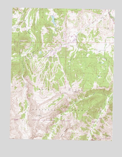
Highland Peak, CO USGS Topographic Map
Click on map above to begin viewing in our Map Viewer.

This topographic map contains these locations and features:
Feature Name Type Latitude Longitude GNIS ID View Map
Baldy MountainSummitN39.1480°W106.9664°180025View Map
Burnt MountainSummitN39.1739°W106.9234°180023View Map
Cozy PointSummitN39.2319°W106.8848°180016View Map
Eagle MountainSummitN39.2192°W106.9900°180009View Map
East Fork Brush CreekStreamN39.2208°W106.9220°180013View Map
East Snowmass and Brush Creek DitchCanalN39.2008°W106.9803°180021View Map
East Snowmass CreekStreamN39.2036°W106.9906°180024View Map
Elk Creek DitchCanalN39.2455°W106.9945°202300View Map
Elk Creek Ditch Number 2CanalN39.2442°W106.9862°169493View Map
Herrick DitchCanalN39.1564°W106.8875°180028View Map
Highland PeakSummitN39.1289°W106.8770°180031View Map
Hunter CreekStreamN39.2411°W106.9800°175223View Map
Johnny DrawValleyN39.2320°W106.9930°201749View Map
KSNO-FM (Snowmass Village)TowerN39.2475°W106.9209°204195View Map
Lemond DitchCanalN39.2383°W106.8945°180015View Map
Marolt ReservoirReservoirN39.1992°W106.8885°180017View Map
Maroon Creek Campground 1LocaleN39.1580°W106.8845°180027View Map
Maroon Creek Campground 2LocaleN39.1464°W106.8937°180029View Map
Maroon Creek Campground 3LocaleN39.1428°W106.8953°180030View Map
Maroon Creek Campground 4LocaleN39.1280°W106.9034°180032View Map
Mayflower MineMineN39.1961°W106.8870°1735445View Map
McKenzie Wildcat DitchCanalN39.2144°W106.9678°180010View Map
Millinee MineMineN39.1817°W106.9248°1684470View Map
Munn Tunnel MineMineN39.2253°W106.9828°1684471View Map
Pitkin CountyCivilN39.2171°W106.9166°198164View Map
Powell Mc Kenzie DitchCanalN39.2247°W106.9778°180008View Map
Snowmass - Wildcat Fire Protection District Snowmass Station 1BuildingN39.2135°W106.9380°2666903View Map
Snowmass VillagePopulated PlaceN39.2130°W106.9378°204832View Map
Snowmass Village Police DepartmentBuildingN39.2114°W106.9475°2757267View Map
Snowmass Village Post OfficePost OfficeN39.2116°W106.9455°2734608View Map
Spring CreekStreamN39.2180°W106.8862°180019View Map
Town of Snowmass VillageCivilN39.2203°W106.9393°2413302View Map
West Fork Brush CreekStreamN39.2100°W106.9512°180012View Map
West Willow CreekStreamN39.1608°W106.9214°180026View Map
Whites LakeLakeN39.1859°W106.8948°180018View Map
Wiese Upper DitchCanalN39.2408°W106.8903°180014View Map
Wildcat DamDamN39.2417°W106.9523°199418View Map
Wildcat ReservoirReservoirN39.2387°W106.9499°180011View Map
Willoughby MountainSummitN39.1428°W106.9950°196505View Map
Willow and Owl DitchCanalN39.1736°W106.9289°180022View Map
Willow CreekStreamN39.1661°W106.8778°180033View Map

Note: Coordinates in the location and feature list above are referenced to NAD83 datum.


Copyright (C) 2008-2025 Ryan Niemi / Sunset Dynamics ... All Rights Reserved