TopoQuest Logo
Do you find TopoQuest useful?
Help keep TopoQuest running and adding new maps/features by donating!
Bitcoin:  19c7KJd3qBynnjoSw5npx9KScwjBe4ifkT
Litecoin:  LXs6TkuXGGXo1vDsWCkWVdjQX94eUKd6ui
Home View Maps Find Maps Find Places Resources & Links


Hightower, Alabama Topographic Map

USGS Map Title: Hightower, AL
USGS Map MRC: 33085E4
DRG (GeoTIFF) Download: o33085e4.tif


Neighboring USGS Topographic Map Quads:


  Heflin, AL  
33085F5
 

  Fruithurst, AL  
33085F4
 

  Tallapoosa South, GA  
33085F3
 

  Ross Mountain, AL  
33085E5
 

  Hightower, AL  
33085E4
 

  Bowdon West, GA  
33085E3
 

  Micaville, AL  
33085D5
 

  Newell, AL  
33085D4
 

  Graham, AL  
33085D3


Map MRC Location:

N34°
W86°
N34°
W85°
H8 H7 H6 H5 H4 H3 H2 H1
G8 G7 G6 G5 G4 G3 G2 G1
F8 F7 F6 F5 F4 F3 F2 F1
E8 E7 E6 E5 E4 E3 E2 E1
D8 D7 D6 D5 D4 D3 D2 D1
C8 C7 C6 C5 C4 C3 C2 C1
B8 B7 B6 B5 B4 B3 B2 B1
A8 A7 A6 A5 A4 A3 A2 A1
N33°
W86°
N33°
W85°

Hightower, AL USGS 1:24K Topographic Map Preview:
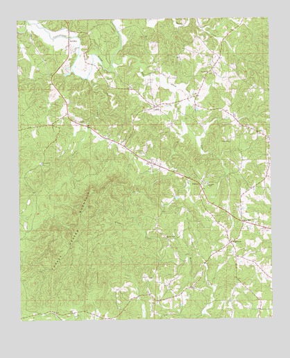
Hightower, AL USGS Topographic Map
Click on map above to begin viewing in our Map Viewer.

This topographic map contains these locations and features:
Feature Name Type Latitude Longitude GNIS ID View Map
Bee HillSummitN33.5284°W85.4636°146307View Map
Bell MillsPopulated PlaceN33.6165°W85.4747°156045View Map
Cleburne County Vocational SchoolSchoolN33.5984°W85.4841°146311View Map
Crumbleys Chapel CemeteryCemeteryN33.5565°W85.4069°1805737View Map
Crumbleys Chapel Church of GodChurchN33.5562°W85.4066°164044View Map
Fordham CemeteryCemeteryN33.6004°W85.4569°118482View Map
Fortner School (historical)SchoolN33.5729°W85.3758°146314View Map
Fowlers Store (historical)LocaleN33.5118°W85.4100°146315View Map
Hensen School (historical)SchoolN33.5134°W85.4161°146318View Map
HightowerPopulated PlaceN33.5318°W85.3955°120085View Map
Hopewell ChurchChurchN33.6023°W85.4055°120378View Map
Howles Grove Church (historical)ChurchN33.5557°W85.4908°146319View Map
Hurricane United Methodist ChurchChurchN33.5657°W85.4886°120579View Map
Johns MountainSummitN33.5193°W85.4608°146320View Map
Johnywady CreekStreamN33.6243°W85.4950°120970View Map
LectaPopulated PlaceN33.5884°W85.4327°156592View Map
Macedonia Church (historical)ChurchN33.5118°W85.4269°146323View Map
McLeroys Store (historical)LocaleN33.5798°W85.3900°146325View Map
Mountain View ChurchChurchN33.5343°W85.4283°123532View Map
Pleasant Grove ChurchChurchN33.5737°W85.3947°124962View Map
Ranburne DivisionCivilN33.5791°W85.3980°165706View Map
Salem Grove ChurchChurchN33.5534°W85.3863°154262View Map
Silas CreekStreamN33.6079°W85.4544°126841View Map
Slate Hill School (historical)SchoolN33.5037°W85.4736°146335View Map
TrickemPopulated PlaceN33.5562°W85.4111°157172View Map
Turkey Heaven MountainSummitN33.5473°W85.4669°128167View Map
Turkey Heaven Mountain Lookout TowerTowerN33.5471°W85.4666°146338View Map
Turkey Heaven Volunteer Fire DepartmentBuildingN33.5754°W85.4544°2683065View Map
Turkey Heaven Volunteer Fire Department SubstationBuildingN33.5091°W85.4337°2683297View Map
Union HillPopulated PlaceN33.5404°W85.3894°157189View Map
Union Hill Baptist ChurchChurchN33.5401°W85.3897°146339View Map
Union Hill CemeteryCemeteryN33.5395°W85.3897°1805739View Map
Verdin ChapelChurchN33.5821°W85.4702°128434View Map
Verdin CreekStreamN33.6009°W85.4661°128435View Map
Wise Chapel CemeteryCemeteryN33.5693°W85.4402°129133View Map
Wise Chapel ChurchChurchN33.5696°W85.4388°146340View Map
Wise Chapel United Methodist ChurchChurchN33.5648°W85.4355°154011View Map
Wise School (historical)SchoolN33.5687°W85.4405°146341View Map

Note: Coordinates in the location and feature list above are referenced to NAD83 datum.


Copyright (C) 2008-2024 Ryan Niemi / Sunset Dynamics ... All Rights Reserved