TopoQuest Logo
Do you find TopoQuest useful?
Help keep TopoQuest running and adding new maps/features by donating!
Bitcoin:  19c7KJd3qBynnjoSw5npx9KScwjBe4ifkT
Litecoin:  LXs6TkuXGGXo1vDsWCkWVdjQX94eUKd6ui
Home View Maps Find Maps Find Places Resources & Links


Graham, Alabama Topographic Map

USGS Map Title: Graham, AL
USGS Map MRC: 33085D3
DRG (GeoTIFF) Download: o33085d3.tif


Neighboring USGS Topographic Map Quads:


  Hightower, AL  
33085E4
 

  Bowdon West, GA  
33085E3
 

  Bowdon East, GA  
33085E2
 

  Newell, AL  
33085D4
 

  Graham, AL  
33085D3
 

  Roopville, GA  
33085D2
 

  Wedowee, AL  
33085C4
 

  Napoleon, AL  
33085C3
 

  Frolona, GA  
33085C2


Map MRC Location:

N34°
W86°
N34°
W85°
H8 H7 H6 H5 H4 H3 H2 H1
G8 G7 G6 G5 G4 G3 G2 G1
F8 F7 F6 F5 F4 F3 F2 F1
E8 E7 E6 E5 E4 E3 E2 E1
D8 D7 D6 D5 D4 D3 D2 D1
C8 C7 C6 C5 C4 C3 C2 C1
B8 B7 B6 B5 B4 B3 B2 B1
A8 A7 A6 A5 A4 A3 A2 A1
N33°
W86°
N33°
W85°

Graham, AL USGS 1:24K Topographic Map Preview:
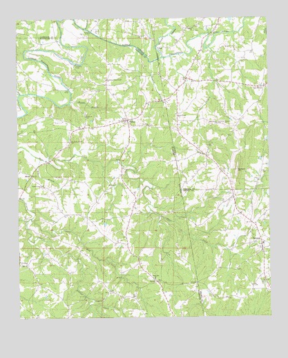
Graham, AL USGS Topographic Map
Click on map above to begin viewing in our Map Viewer.

This topographic map contains these locations and features:
Feature Name Type Latitude Longitude GNIS ID View Map
BethelPopulated PlaceN33.3862°W85.3041°163252View Map
Bethel East ChurchChurchN33.3912°W85.3074°114087View Map
Bethel East Volunteer Fire Department Station 14BuildingN33.4008°W85.3181°2683141View Map
Bethelhem ChurchChurchN33.4932°W85.2774°311215View Map
Bethena Church CemeteryCemeteryN33.4596°W85.3411°114099View Map
Bethlehem Camp Ground ChurchChurchN33.4746°W85.3308°114108View Map
Bethlehem CemeteryCemeteryN33.4932°W85.2777°358284View Map
Bethlehem Primitive Baptist ChurchChurchN33.4934°W85.2777°350067View Map
Blackjack MountainSummitN33.4368°W85.2658°354757View Map
Buchanan Memorial CemeteryCemeteryN33.4559°W85.2749°354893View Map
BucktownPopulated PlaceN33.4748°W85.2905°350083View Map
Bud Coffee BranchStreamN33.4862°W85.3130°140197View Map
BurgessPopulated PlaceN33.3896°W85.2861°347007View Map
City of EphesusCivilN33.4070°W85.2596°2403568View Map
Coats CemeteryCemeteryN33.3948°W85.2652°347020View Map
Coles BridgeBridgeN33.4709°W85.3494°116418View Map
Coppers Rock CreekStreamN33.4165°W85.3686°116621View Map
DotLocaleN33.4876°W85.3041°313557View Map
EphesusPopulated PlaceN33.4071°W85.2544°355709View Map
Ephesus Baptist ChurchChurchN33.4032°W85.2538°347037View Map
Ephesus CemeteryCemeteryN33.4018°W85.2538°347038View Map
Ephesus Elementary SchoolSchoolN33.4058°W85.2533°347039View Map
Ephesus Fire Department Station 3BuildingN33.4024°W85.2538°2604463View Map
Farmer CreekStreamN33.4959°W85.3402°118203View Map
Friendship Church (historical)ChurchN33.4746°W85.2905°349581View Map
GrahamPopulated PlaceN33.4576°W85.3208°119207View Map
Graham Census Designated PlaceCensusN33.4552°W85.3231°2582677View Map
Graham Post OfficePost OfficeN33.4573°W85.3202°167845View Map
Graham Post OfficePost OfficeN33.4583°W85.3193°1668737View Map
HawkPopulated PlaceN33.4346°W85.3686°156456View Map
Herrens Grove ChurchChurchN33.4301°W85.3636°119998View Map
Indian CreekStreamN33.4837°W85.3019°315896View Map
KaylorPopulated PlaceN33.4715°W85.3483°140227View Map
Knight BranchStreamN33.4654°W85.3488°121269View Map
Knokes CreekStreamN33.4684°W85.3733°121275View Map
Lovvorn CreekStreamN33.4876°W85.2788°317453View Map
Midway CemeteryCemeteryN33.4948°W85.2861°349637View Map
Midway ChurchChurchN33.4957°W85.2869°318129View Map
Midway School (historical)SchoolN33.4959°W85.2874°349639View Map
Mount Oliver ChurchChurchN33.4562°W85.2755°318783View Map
Muckfau BridgeBridgeN33.4946°W85.3383°123541View Map
New MexicoLocaleN33.4709°W85.2522°319479View Map
Old Shiloh Church CemeteryCemeteryN33.4490°W85.3488°124252View Map
Prospect Congregational Methodist ChurchChurchN33.3818°W85.3336°125306View Map
ProvidencePopulated PlaceN33.3990°W85.3736°135803View Map
Providence ChurchChurchN33.3971°W85.3713°125332View Map
Reeves School (historical)SchoolN33.4787°W85.2527°349696View Map
Rice BranchStreamN33.4415°W85.3638°125590View Map
Saint James ChurchChurchN33.4554°W85.3099°126108View Map
Sardis CemeteryCemeteryN33.4429°W85.2833°349714View Map
Sardis ChurchChurchN33.4432°W85.2824°322545View Map
Saxon CrossroadsLocaleN33.4182°W85.3399°135818View Map
SewellPopulated PlaceN33.3898°W85.3063°157041View Map
Shiloh ChurchChurchN33.4576°W85.3233°126748View Map
Tanyard BranchStreamN33.4818°W85.3088°127677View Map
Thompson BridgeBridgeN33.4812°W85.3458°153684View Map
Unity CemeteryCemeteryN33.4593°W85.2947°349749View Map
Unity of God ChurchChurchN33.4590°W85.2949°324594View Map
Victory Cathedral ChurchChurchN33.4351°W85.3680°163584View Map
West LakeReservoirN33.4999°W85.2683°339924View Map
West Lake DamDamN33.4984°W85.2683°339923View Map

Note: Coordinates in the location and feature list above are referenced to NAD83 datum.


Copyright (C) 2008-2024 Ryan Niemi / Sunset Dynamics ... All Rights Reserved