TopoQuest Logo
Do you find TopoQuest useful?
Help keep TopoQuest running and adding new maps/features by donating!
Bitcoin:  19c7KJd3qBynnjoSw5npx9KScwjBe4ifkT
Litecoin:  LXs6TkuXGGXo1vDsWCkWVdjQX94eUKd6ui
Home View Maps Find Maps Find Places Resources & Links


Hillsboro, Georgia Topographic Map

USGS Map Title: Hillsboro, GA
USGS Map MRC: 33083B6
DRG (GeoTIFF) Download: o33083b6.tif


Neighboring USGS Topographic Map Quads:


  Lloyd Shoals Dam, GA  
33083C7
 

  Monticello, GA  
33083C6
 

  Smithboro, GA  
33083C5
 

  Berner, GA  
33083B7
 

  Hillsboro, GA  
33083B6
 

  Stanfordville, GA  
33083B5
 

  East Juliette, GA  
33083A7
 

  Dames Ferry, GA  
33083A6
 

  Gray, GA  
33083A5


Map MRC Location:

N34°
W84°
N34°
W83°
H8 H7 H6 H5 H4 H3 H2 H1
G8 G7 G6 G5 G4 G3 G2 G1
F8 F7 F6 F5 F4 F3 F2 F1
E8 E7 E6 E5 E4 E3 E2 E1
D8 D7 D6 D5 D4 D3 D2 D1
C8 C7 C6 C5 C4 C3 C2 C1
B8 B7 B6 B5 B4 B3 B2 B1
A8 A7 A6 A5 A4 A3 A2 A1
N33°
W84°
N33°
W83°

Hillsboro, GA USGS 1:24K Topographic Map Preview:
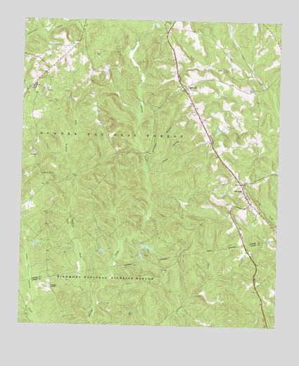
Hillsboro, GA USGS Topographic Map
Click on map above to begin viewing in our Map Viewer.

This topographic map contains these locations and features:
Feature Name Type Latitude Longitude GNIS ID View Map
AdgatevillePopulated PlaceN33.2232°W83.6710°354263View Map
Adgateville Baptist ChurchChurchN33.2212°W83.6710°346114View Map
Camp Six Hunt CampLocaleN33.2068°W83.7093°330648View Map
Crossroad ChurchChurchN33.2207°W83.6696°346121View Map
Deep Well Hunt CampLocaleN33.1899°W83.7074°330643View Map
Freemans BranchStreamN33.1907°W83.6874°327884View Map
Gladesville CreekStreamN33.1629°W83.7480°327941View Map
Hardin School (historical)SchoolN33.1837°W83.7274°346130View Map
Hay House ChurchChurchN33.2149°W83.6707°346131View Map
HillsboroPopulated PlaceN33.1799°W83.6410°356309View Map
Hillsboro Baptist ChurchChurchN33.1835°W83.6427°346137View Map
Hillsboro CemeteryCemeteryN33.1837°W83.6427°349363View Map
Hillsboro DivisionCivilN33.2132°W83.6886°1936316View Map
Hillsboro Hunt CampLocaleN33.1685°W83.6630°330646View Map
Hillsboro Post OfficePost OfficeN33.1799°W83.6407°346138View Map
Hillsboro United Methodist ChurchChurchN33.1779°W83.6399°346139View Map
Jasper County Emergency Services Station 4 HillsboroBuildingN33.1769°W83.6396°2604214View Map
John Gordon CemeteryCemeteryN33.1476°W83.6799°345365View Map
John H Tillman CemeteryCemeteryN33.1950°W83.7032°330647View Map
King BranchStreamN33.2279°W83.6368°328405View Map
King ChapelChurchN33.2218°W83.6699°346153View Map
Kunsford (historical)Populated PlaceN33.1824°W83.7377°346155View Map
Little Gladesville CreekStreamN33.1632°W83.7482°328549View Map
Lungsford Hunt CampLocaleN33.1776°W83.7327°330644View Map
Maddox Chapel ChurchChurchN33.1843°W83.6416°346157View Map
McKissack ChurchChurchN33.1918°W83.6502°346158View Map
Newby BranchStreamN33.1973°W83.7282°346170View Map
OIG Hunt CampLocaleN33.1676°W83.7382°330645View Map
Piedmont Wildlife LakeReservoirN33.1576°W83.6886°337192View Map
Piedmont Wildlife Lake DamDamN33.1568°W83.6916°337191View Map
Rock Zion ChurchChurchN33.1868°W83.7396°329478View Map
Stalking Head CreekStreamN33.1321°W83.7132°356551View Map
Towns BranchStreamN33.1896°W83.6891°330036View Map
Tribble FieldsLocaleN33.1401°W83.7343°330049View Map

Note: Coordinates in the location and feature list above are referenced to NAD83 datum.


Copyright (C) 2008-2025 Ryan Niemi / Sunset Dynamics ... All Rights Reserved