TopoQuest Logo
Do you find TopoQuest useful?
Help keep TopoQuest running and adding new maps/features by donating!
Bitcoin:  19c7KJd3qBynnjoSw5npx9KScwjBe4ifkT
Litecoin:  LXs6TkuXGGXo1vDsWCkWVdjQX94eUKd6ui
Home View Maps Find Maps Find Places Resources & Links


Lloyd Shoals Dam, Georgia Topographic Map

USGS Map Title: Lloyd Shoals Dam, GA
USGS Map MRC: 33083C7
DRG (GeoTIFF) Download: o33083c7.tif


Neighboring USGS Topographic Map Quads:


  Worthville, GA  
33083D8
 

  Stewart, GA  
33083D7
 

  Farrar, GA  
33083D6
 

  Jackson, GA  
33083C8
 

  Lloyd Shoals Dam, GA  
33083C7
 

  Monticello, GA  
33083C6
 

  Indian Springs, GA  
33083B8
 

  Berner, GA  
33083B7
 

  Hillsboro, GA  
33083B6


Map MRC Location:

N34°
W84°
N34°
W83°
H8 H7 H6 H5 H4 H3 H2 H1
G8 G7 G6 G5 G4 G3 G2 G1
F8 F7 F6 F5 F4 F3 F2 F1
E8 E7 E6 E5 E4 E3 E2 E1
D8 D7 D6 D5 D4 D3 D2 D1
C8 C7 C6 C5 C4 C3 C2 C1
B8 B7 B6 B5 B4 B3 B2 B1
A8 A7 A6 A5 A4 A3 A2 A1
N33°
W84°
N33°
W83°

Lloyd Shoals Dam, GA USGS 1:24K Topographic Map Preview:
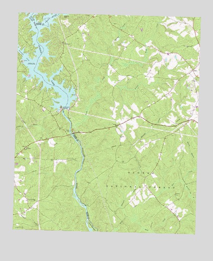
Lloyd Shoals Dam, GA USGS Topographic Map
Click on map above to begin viewing in our Map Viewer.

This topographic map contains these locations and features:
Feature Name Type Latitude Longitude GNIS ID View Map
Alcovy RiverStreamN33.3668°W83.8613°354275View Map
Barber CemeteryCemeteryN33.2937°W83.8727°345798View Map
Berry CemeteryCemeteryN33.2909°W83.8482°327078View Map
Berry ChurchChurchN33.2912°W83.8674°327079View Map
BethelPopulated PlaceN33.3448°W83.7543°354585View Map
Bethel Baptist ChurchChurchN33.3429°W83.7577°346119View Map
Bethel Grove ChurchChurchN33.3582°W83.7593°354642View Map
Bethlehem ChurchChurchN33.3576°W83.8427°327086View Map
Concord CemeteryCemeteryN33.3107°W83.8055°349360View Map
Concord ChurchChurchN33.3057°W83.8024°327509View Map
Concord Hunt CampLocaleN33.2904°W83.8055°330681View Map
Concord Primitive Baptist ChurchChurchN33.3112°W83.8060°355259View Map
Edwards Store (historical)LocaleN33.3568°W83.8013°346123View Map
Elizabeth Church (historical)ChurchN33.2910°W83.8482°345814View Map
Fellowship CemeteryCemeteryN33.2723°W83.7638°349362View Map
Fellowship ChurchChurchN33.2726°W83.7643°355786View Map
Friendship ChurchChurchN33.2971°W83.8674°355943View Map
Friendship Hunt CampLocaleN33.2601°W83.7766°330684View Map
Friendship School (historical)SchoolN33.2968°W83.8677°345822View Map
Giles Ferry (historical)CrossingN33.2768°W83.8327°345823View Map
Hardys CreekStreamN33.3512°W83.8099°328061View Map
Harmon Pye BranchStreamN33.2804°W83.7591°328065View Map
Herds CreekStreamN33.3023°W83.8366°328119View Map
Horse Hunt CampLocaleN33.2573°W83.7707°330679View Map
Jackson LakeReservoirN33.3672°W83.8580°328300View Map
Keys Store (historical)LocaleN33.3523°W83.8299°346152View Map
Kinnard CreekStreamN33.2590°W83.7977°328412View Map
Kinnard Horse TrailTrailN33.2690°W83.8010°330683View Map
Lane CemeteryCemeteryN33.2912°W83.8007°328443View Map
Leverette CemeteryCemeteryN33.3746°W83.8255°328491View Map
Leverette NeckBayN33.3748°W83.8424°328492View Map
Lloyd Shoals DamDamN33.3210°W83.8413°328592View Map
Maddox CemeteryCemeteryN33.3176°W83.8513°345855View Map
Mechanicsville (historical)Populated PlaceN33.3660°W83.8341°346159View Map
Minter CemeteryCemeteryN33.3293°W83.7732°328821View Map
Moores Chapel (historical)ChurchN33.3096°W83.8452°345861View Map
Mount Olive Church (historical)ChurchN33.3623°W83.7955°346167View Map
Mount Zion CemeteryCemeteryN33.3634°W83.8308°349368View Map
Mount Zion ChurchChurchN33.3640°W83.8299°328913View Map
Oak Hill School (historical)SchoolN33.3021°W83.8574°345864View Map
Old Dempsey Ferry (historical)CrossingN33.3440°W83.8624°345865View Map
Old Keys Ferry (historical)CrossingN33.3660°W83.8618°345866View Map
Panther CreekStreamN33.3090°W83.8677°329129View Map
Persons CreekStreamN33.3401°W83.8124°329178View Map
Pittman Ferry (historical)CrossingN33.3068°W83.8374°345868View Map
Rush CreekStreamN33.2579°W83.7910°329545View Map
Rush Creek Hunt CampLocaleN33.2554°W83.7838°330680View Map
Sardis Church (historical)ChurchN33.3160°W83.7568°346183View Map
Smith Ferry (historical)CrossingN33.2626°W83.8249°345872View Map
Smiths Mill (historical)Populated PlaceN33.3173°W83.8388°346186View Map
South RiverStreamN33.3682°W83.8632°356546View Map
Spring BranchStreamN33.2890°W83.7507°329788View Map
Thomas Ferry (historical)CrossingN33.2926°W83.8280°345878View Map
Tussahaw CreekStreamN33.3446°W83.8646°356601View Map
Tyler CrossroadsLocaleN33.2654°W83.7702°346188View Map
Union Ridge ChurchChurchN33.2673°W83.8602°330115View Map
Wallers Academy (historical)SchoolN33.3021°W83.7735°346190View Map
Warren Academy (historical)SchoolN33.3610°W83.7949°346191View Map
Williams CemeteryCemeteryN33.3157°W83.7688°1952427View Map
Williams CemeteryCemeteryN33.3382°W83.7522°330293View Map
Yellow Water CreekStreamN33.3018°W83.8330°330399View Map

Note: Coordinates in the location and feature list above are referenced to NAD83 datum.


Copyright (C) 2008-2024 Ryan Niemi / Sunset Dynamics ... All Rights Reserved