TopoQuest Logo
Do you find TopoQuest useful?
Help keep TopoQuest running and adding new maps/features by donating!
Bitcoin:  19c7KJd3qBynnjoSw5npx9KScwjBe4ifkT
Litecoin:  LXs6TkuXGGXo1vDsWCkWVdjQX94eUKd6ui
Home View Maps Find Maps Find Places Resources & Links


Hoboken West, Georgia Topographic Map

USGS Map Title: Hoboken West, GA
USGS Map MRC: 31082B2
DRG (GeoTIFF) Download: o31082b2.tif


Neighboring USGS Topographic Map Quads:


  Blackshear West, GA  
31082C3
 

  Blackshear East, GA  
31082C2
 

  Patterson SE, GA  
31082C1
 

  Waycross East, GA  
31082B3
 

  Hoboken West, GA  
31082B2
 

  Hoboken East, GA  
31082B1
 

  Waycross SE, GA  
31082A3
 

  Fort Mudge, GA  
31082A2
 

  Winokur, GA  
31082A1


Map MRC Location:

N32°
W83°
N32°
W82°
H8 H7 H6 H5 H4 H3 H2 H1
G8 G7 G6 G5 G4 G3 G2 G1
F8 F7 F6 F5 F4 F3 F2 F1
E8 E7 E6 E5 E4 E3 E2 E1
D8 D7 D6 D5 D4 D3 D2 D1
C8 C7 C6 C5 C4 C3 C2 C1
B8 B7 B6 B5 B4 B3 B2 B1
A8 A7 A6 A5 A4 A3 A2 A1
N31°
W83°
N31°
W82°

Hoboken West, GA USGS 1:24K Topographic Map Preview:
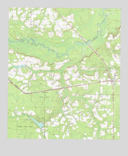
Hoboken West, GA USGS Topographic Map
Click on map above to begin viewing in our Map Viewer.

This topographic map contains these locations and features:
Feature Name Type Latitude Longitude GNIS ID View Map
Altman Bridge (historical)BridgeN31.2413°W82.1412°349002View Map
Big BranchStreamN31.1977°W82.1732°311332View Map
Big CreekStreamN31.2163°W82.1629°311364View Map
Blue Hole ReachChannelN31.2044°W82.1910°349004View Map
Calvary Volunteer Fire DepartmentBuildingN31.2010°W82.2461°2604852View Map
Cascade ChurchChurchN31.1844°W82.1712°355027View Map
City of HobokenCivilN31.1812°W82.1313°2404706View Map
Clay BluffCliffN31.2166°W82.2235°349008View Map
Dark Hole ReachChannelN31.2183°W82.1740°349010View Map
Dix BranchStreamN31.2272°W82.1462°355504View Map
Dowling Bridge (historical)BridgeN31.2030°W82.1954°349012View Map
Enon CemeteryCemeteryN31.2416°W82.2268°349059View Map
Enon ChurchChurchN31.2416°W82.2262°313962View Map
Georgia Lions Camp for the BlindLocaleN31.1349°W82.2137°357678View Map
Gold LakeLakeN31.2188°W82.2401°349063View Map
Hickox's CemeteryCemeteryN31.2002°W82.1658°335833View Map
Higans BluffCliffN31.2155°W82.2243°349020View Map
High Bluff ChurchChurchN31.1588°W82.1868°315382View Map
HobokenPopulated PlaceN31.1811°W82.1348°331999View Map
Hoboken Baptist ChurchChurchN31.1808°W82.1307°335820View Map
Hoboken District Volunteer Fire DepartmentBuildingN31.1817°W82.1321°2603551View Map
Hoboken DivisionCivilN31.1503°W82.1357°1936320View Map
Hoboken Elementary SchoolSchoolN31.1869°W82.1302°335821View Map
Hoboken Police DepartmentBuildingN31.1817°W82.1325°2733583View Map
Jumping BluffCliffN31.2041°W82.1826°349021View Map
Lake FloreeReservoirN31.1919°W82.2310°314232View Map
Lake Floree DamDamN31.1941°W82.2310°338071View Map
Laura S Walker LakeReservoirN31.1402°W82.2158°338497View Map
Laura S Walker State ParkParkN31.1433°W82.2165°316665View Map
Laura S Walker State Park Lake DamDamN31.1402°W82.2098°338496View Map
Martin CemeteryCemeteryN31.1661°W82.1468°317736View Map
Mill CreekStreamN31.1899°W82.1901°318213View Map
Moore CemeteryCemeteryN31.2244°W82.1309°318431View Map
Mount Calvary ChurchChurchN31.1505°W82.1523°318571View Map
New Hope ChurchChurchN31.1908°W82.2496°319367View Map
Oak Hill ChurchChurchN31.1933°W82.1993°335828View Map
Pierce ChapelChurchN31.1402°W82.1793°320492View Map
Saint Johns CemeteryCemeteryN31.2474°W82.2140°349095View Map
Saint Johns ChurchChurchN31.2474°W82.2135°322108View Map
Sand Slough Bridge (historical)BridgeN31.2063°W82.1940°349030View Map
SchlattervillePopulated PlaceN31.1722°W82.1998°332992View Map
South Prong Big CreekStreamN31.1702°W82.1846°323270View Map
The Lakes Golf Couse at Laura S WalkerLocaleN31.1346°W82.2264°2502692View Map
Thift CemeteryCemeteryN31.2005°W82.1662°324064View Map
Yellow BluffCliffN31.2288°W82.1507°349107View Map

Note: Coordinates in the location and feature list above are referenced to NAD83 datum.


Copyright (C) 2008-2024 Ryan Niemi / Sunset Dynamics ... All Rights Reserved