TopoQuest Logo
Do you find TopoQuest useful?
Help keep TopoQuest running and adding new maps/features by donating!
Bitcoin:  19c7KJd3qBynnjoSw5npx9KScwjBe4ifkT
Litecoin:  LXs6TkuXGGXo1vDsWCkWVdjQX94eUKd6ui
Home View Maps Find Maps Find Places Resources & Links


Patterson SE, Georgia Topographic Map

USGS Map Title: Patterson SE, GA
USGS Map MRC: 31082C1
DRG (GeoTIFF) Download: o31082c1.tif


Neighboring USGS Topographic Map Quads:


  Patterson, GA  
31082D2
 

  Screven, GA  
31082D1
 

  McKinnon, GA  
31081D8
 

  Blackshear East, GA  
31082C2
 

  Patterson SE, GA  
31082C1
 

  Hortense, GA  
31081C8
 

  Hoboken West, GA  
31082B2
 

  Hoboken East, GA  
31082B1
 

  Nahunta, GA  
31081B8


Map MRC Location:

N32°
W83°
N32°
W82°
H8 H7 H6 H5 H4 H3 H2 H1
G8 G7 G6 G5 G4 G3 G2 G1
F8 F7 F6 F5 F4 F3 F2 F1
E8 E7 E6 E5 E4 E3 E2 E1
D8 D7 D6 D5 D4 D3 D2 D1
C8 C7 C6 C5 C4 C3 C2 C1
B8 B7 B6 B5 B4 B3 B2 B1
A8 A7 A6 A5 A4 A3 A2 A1
N31°
W83°
N31°
W82°

Patterson SE, GA USGS 1:24K Topographic Map Preview:
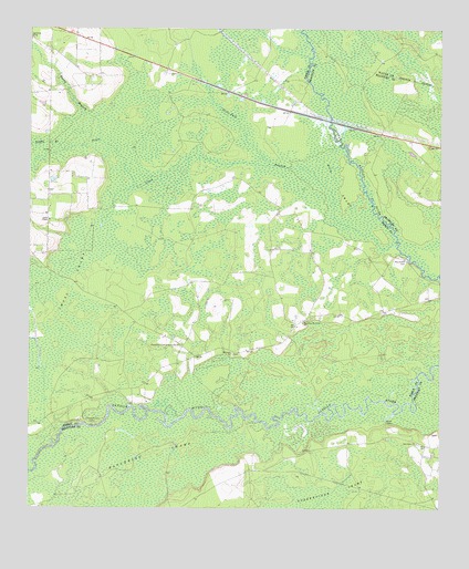
Patterson SE, GA USGS Topographic Map
Click on map above to begin viewing in our Map Viewer.

This topographic map contains these locations and features:
Feature Name Type Latitude Longitude GNIS ID View Map
Dowling FordCrossingN31.2755°W82.0765°349013View Map
Dowling PlaceLocaleN31.2774°W82.0935°349058View Map
Dowlings Ferry LandingLocaleN31.2733°W82.0590°349014View Map
Griffin BranchStreamN31.3430°W82.1148°314900View Map
Indian BluffCliffN31.2774°W82.0932°349067View Map
Laura ChapelChurchN31.3252°W82.1187°316663View Map
Lindsay Grace CampLocaleN31.2724°W82.1043°316897View Map
Mud SwampSwampN31.3281°W82.1004°319125View Map
Oak Grove ChurchChurchN31.2674°W82.0068°319766View Map
Oak SuckSwampN31.2752°W82.0315°349026View Map
Otter CreekStreamN31.3399°W82.0515°320114View Map
Prospect ChurchChurchN31.2905°W82.0629°321158View Map
Rattlesnake Bridge (historical)BridgeN31.2713°W82.1040°349029View Map
Raulerson CemeteryCemeteryN31.3152°W82.0104°321323View Map
Raulerson Community CenterLocaleN31.2927°W82.0779°321324View Map
Raulerson Memorial ChurchChurchN31.2986°W82.0415°321325View Map
Raulerson SwampSwampN31.2612°W82.0879°321326View Map
Reedy BranchStreamN31.3458°W82.1032°321439View Map
Sixty Foot BranchStreamN31.3186°W82.0132°323051View Map
Zirkle (historical)Populated PlaceN31.3544°W82.0457°349109View Map

Note: Coordinates in the location and feature list above are referenced to NAD83 datum.


Copyright (C) 2008-2025 Ryan Niemi / Sunset Dynamics ... All Rights Reserved