TopoQuest Logo
Do you find TopoQuest useful?
Help keep TopoQuest running and adding new maps/features by donating!
Bitcoin:  19c7KJd3qBynnjoSw5npx9KScwjBe4ifkT
Litecoin:  LXs6TkuXGGXo1vDsWCkWVdjQX94eUKd6ui
Home View Maps Find Maps Find Places Resources & Links


Baconton South, Georgia Topographic Map

USGS Map Title: Baconton South, GA
USGS Map MRC: 31084C2
DRG (GeoTIFF) Download: o31084c2.tif


Neighboring USGS Topographic Map Quads:


  Red Store Crossroads, GA  
31084D3
 

  Baconton North, GA  
31084D2
 

  Putney, GA  
31084D1
 

  Newton, GA  
31084C3
 

  Baconton South, GA  
31084C2
 

  Sale City, GA  
31084C1
 

  Branchville, GA  
31084B3
 

  Camilla, GA  
31084B2
 

  Cotton, GA  
31084B1


Map MRC Location:

N32°
W85°
N32°
W84°
H8 H7 H6 H5 H4 H3 H2 H1
G8 G7 G6 G5 G4 G3 G2 G1
F8 F7 F6 F5 F4 F3 F2 F1
E8 E7 E6 E5 E4 E3 E2 E1
D8 D7 D6 D5 D4 D3 D2 D1
C8 C7 C6 C5 C4 C3 C2 C1
B8 B7 B6 B5 B4 B3 B2 B1
A8 A7 A6 A5 A4 A3 A2 A1
N31°
W85°
N31°
W84°

Baconton South, GA USGS 1:24K Topographic Map Preview:
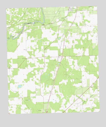
Baconton South, GA USGS Topographic Map
Click on map above to begin viewing in our Map Viewer.

This topographic map contains these locations and features:
Feature Name Type Latitude Longitude GNIS ID View Map
AdelaidePopulated PlaceN31.2668°W84.1485°334202View Map
Beautiful Ligh ChurchChurchN31.3155°W84.2244°310969View Map
Bethel ChurchChurchN31.3043°W84.2474°354637View Map
China Grove CemeteryCemeteryN31.3257°W84.1971°312642View Map
China Grove Church (historical)ChurchN31.3252°W84.1980°343624View Map
Creek CemeteryCemeteryN31.3560°W84.1891°313101View Map
Culpepper SpringSpringN31.3463°W84.2291°313209View Map
Double SpringsSpringN31.3399°W84.2494°313585View Map
FlintPopulated PlaceN31.3166°W84.1791°355842View Map
Flint Baptist Church (historical)ChurchN31.3138°W84.1805°343634View Map
Habakkuk ChurchChurchN31.2855°W84.1488°314997View Map
Hicksville Church (historical)ChurchN31.2738°W84.2124°334203View Map
Horseshoe BendBendN31.3430°W84.2438°315721View Map
Pleasant Hill ChurchChurchN31.2799°W84.1382°320919View Map
Prossers IslandIslandN31.3571°W84.2124°321178View Map
Raccoon CreekStreamN31.3555°W84.1999°321268View Map
Rock LakeLakeN31.2534°W84.2102°321743View Map
Rock PondLakeN31.2660°W84.2218°321746View Map
Saint Mary ChurchChurchN31.3121°W84.1830°322187View Map
Saint Pauls Church (historical)ChurchN31.2632°W84.1485°334205View Map
The FlatSwampN31.2655°W84.1863°324042View Map
Walton SpringSpringN31.3543°W84.1994°324830View Map
Wethington SloughStreamN31.3591°W84.1752°325111View Map
WQVE-FM (Camilla)TowerN31.3143°W84.2049°352651View Map

Note: Coordinates in the location and feature list above are referenced to NAD83 datum.


Copyright (C) 2008-2024 Ryan Niemi / Sunset Dynamics ... All Rights Reserved