TopoQuest Logo
Do you find TopoQuest useful?
Help keep TopoQuest running and adding new maps/features by donating!
Bitcoin:  19c7KJd3qBynnjoSw5npx9KScwjBe4ifkT
Litecoin:  LXs6TkuXGGXo1vDsWCkWVdjQX94eUKd6ui
Home View Maps Find Maps Find Places Resources & Links


Putney, Georgia Topographic Map

USGS Map Title: Putney, GA
USGS Map MRC: 31084D1
DRG (GeoTIFF) Download: o31084d1.tif


Neighboring USGS Topographic Map Quads:


  Albany West, GA  
31084E2
 

  Albany East, GA  
31084E1
 

  Acree, GA  
31083E8
 

  Baconton North, GA  
31084D2
 

  Putney, GA  
31084D1
 

  Bridgeboro, GA  
31083D8
 

  Baconton South, GA  
31084C2
 

  Sale City, GA  
31084C1
 

  Doerun, GA  
31083C8


Map MRC Location:

N32°
W85°
N32°
W84°
H8 H7 H6 H5 H4 H3 H2 H1
G8 G7 G6 G5 G4 G3 G2 G1
F8 F7 F6 F5 F4 F3 F2 F1
E8 E7 E6 E5 E4 E3 E2 E1
D8 D7 D6 D5 D4 D3 D2 D1
C8 C7 C6 C5 C4 C3 C2 C1
B8 B7 B6 B5 B4 B3 B2 B1
A8 A7 A6 A5 A4 A3 A2 A1
N31°
W85°
N31°
W84°

Putney, GA USGS 1:24K Topographic Map Preview:
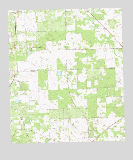
Putney, GA USGS Topographic Map
Click on map above to begin viewing in our Map Viewer.

This topographic map contains these locations and features:
Feature Name Type Latitude Longitude GNIS ID View Map
Albany Fire Department Station 9BuildingN31.4759°W84.1159°2604154View Map
Antioch Baptist ChurchChurchN31.4805°W84.0180°354331View Map
Antioch CemeteryCemeteryN31.4799°W84.0188°1671030View Map
Baconton DivisionCivilN31.3804°W84.1042°1936096View Map
Hollands FollyPopulated PlaceN31.4630°W84.1027°1671138View Map
Loretta HeightsPopulated PlaceN31.4905°W84.1194°1671156View Map
Mount Calvary ChurchChurchN31.4338°W84.1177°318572View Map
Mount Enon ChurchChurchN31.3993°W84.1138°318632View Map
Mount Moriah Number 2 ChurchChurchN31.4863°W84.1160°344300View Map
Nelms (historical)LocaleN31.4877°W84.0249°334159View Map
New Salem ChurchChurchN31.3974°W84.1124°319531View Map
Piney Grove Church (historical)ChurchN31.4980°W84.0374°334160View Map
Pleasant Grove ChurchChurchN31.4249°W84.0291°320799View Map
Pleasant Grove Volunteer Fire DepartmentBuildingN31.4273°W84.0609°2604201View Map
PutneyPopulated PlaceN31.4702°W84.1177°332767View Map
Putney Census Designated PlaceCensusN31.4755°W84.1006°2403456View Map
Rocky Hill ChurchChurchN31.4432°W84.0618°321847View Map
Saint Mary ChurchChurchN31.4446°W84.0196°322186View Map
Weatherby LakeReservoirN31.4338°W84.0241°342050View Map
Weatherby Lake DamDamN31.4318°W84.0232°342049View Map
Williams Spring ChurchChurchN31.4980°W84.1102°334161View Map
WilliamsburgPopulated PlaceN31.4982°W84.1152°333434View Map

Note: Coordinates in the location and feature list above are referenced to NAD83 datum.


Copyright (C) 2008-2024 Ryan Niemi / Sunset Dynamics ... All Rights Reserved