TopoQuest Logo
Do you find TopoQuest useful?
Help keep TopoQuest running and adding new maps/features by donating!
Bitcoin:  19c7KJd3qBynnjoSw5npx9KScwjBe4ifkT
Litecoin:  LXs6TkuXGGXo1vDsWCkWVdjQX94eUKd6ui
Home View Maps Find Maps Find Places Resources & Links


Hohenwald, Tennessee Topographic Map

USGS Map Title: Hohenwald, TN
USGS Map MRC: 35087E5
DRG (GeoTIFF) Download: o35087e5.tif


Neighboring USGS Topographic Map Quads:


  Pleasantville, TN  
35087F6
 

  Beaverdam Springs, TN  
35087F5
 

  Sunrise, TN  
35087F4
 

  Graves Spring, TN  
35087E6
 

  Hohenwald, TN  
35087E5
 

  Gordonsburg, TN  
35087E4
 

  Topsy, TN  
35087D6
 

  Riverside, TN  
35087D5
 

  Henryville, TN  
35087D4


Map MRC Location:

N36°
W88°
N36°
W87°
H8 H7 H6 H5 H4 H3 H2 H1
G8 G7 G6 G5 G4 G3 G2 G1
F8 F7 F6 F5 F4 F3 F2 F1
E8 E7 E6 E5 E4 E3 E2 E1
D8 D7 D6 D5 D4 D3 D2 D1
C8 C7 C6 C5 C4 C3 C2 C1
B8 B7 B6 B5 B4 B3 B2 B1
A8 A7 A6 A5 A4 A3 A2 A1
N35°
W88°
N35°
W87°

Hohenwald, TN USGS 1:24K Topographic Map Preview:
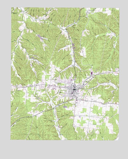
Hohenwald, TN USGS Topographic Map
Click on map above to begin viewing in our Map Viewer.

This topographic map contains these locations and features:
Feature Name Type Latitude Longitude GNIS ID View Map
Ammons HollowValleyN35.5810°W87.5550°1307306View Map
Ashton BranchStreamN35.6051°W87.5667°1307307View Map
Baker HollowValleyN35.5934°W87.6185°1307308View Map
Barn HollowValleyN35.6035°W87.5647°1307310View Map
Bash HollowValleyN35.6130°W87.5856°1307311View Map
Bastin CemeteryCemeteryN35.6203°W87.6081°1309364View Map
Baston CemeteryCemeteryN35.6156°W87.6033°1307312View Map
Bell HollowValleyN35.6103°W87.5780°1309365View Map
Blackburn CemeteryCemeteryN35.5684°W87.6245°1309367View Map
Bland HollowValleyN35.6030°W87.5108°1307313View Map
Blann CemeteryCemeteryN35.6062°W87.5147°1309369View Map
BlondyPopulated PlaceN35.5604°W87.5328°1307314View Map
Blondy ChurchChurchN35.5590°W87.5356°1307315View Map
Blondy HollowValleyN35.5728°W87.5516°1307316View Map
Booker HollowValleyN35.5387°W87.5780°1307317View Map
Brown CemeteryCemeteryN35.6215°W87.6125°1307319View Map
Brown HollowValleyN35.5965°W87.5893°1307320View Map
Buck HollowValleyN35.5916°W87.5568°1307321View Map
Carters ProspectMineN35.5445°W87.5792°1309377View Map
City of HohenwaldCivilN35.5519°W87.5536°2404709View Map
Clayton HollowValleyN35.6148°W87.5942°1307322View Map
Coble ProspectMineN35.6065°W87.5181°1309385View Map
Coldwater HollowValleyN35.6077°W87.5565°1307323View Map
Commissioner District 3CivilN35.5965°W87.5770°2464168View Map
Commissioner District 6CivilN35.5629°W87.5582°2464552View Map
Commissioner District 7CivilN35.5180°W87.5454°2464626View Map
Commissioner District 8CivilN35.5472°W87.5338°2464685View Map
Commissioner District 9CivilN35.5486°W87.5639°2464732View Map
Conder CemeteryCemeteryN35.6112°W87.5822°1307324View Map
Coon HollowValleyN35.5958°W87.5575°1307325View Map
Cory BranchStreamN35.5992°W87.5042°1307326View Map
Cotton BranchStreamN35.6070°W87.6084°1307327View Map
Crawford HollowValleyN35.5750°W87.6236°1307328View Map
Crystal SpringSpringN35.5004°W87.5617°1309389View Map
Darbytown BranchStreamN35.5998°W87.6142°1307329View Map
Dean HollowValleyN35.5992°W87.5259°1307330View Map
Deavers CemeteryCemeteryN35.5503°W87.6011°1307331View Map
Downey CemeteryCemeteryN35.5706°W87.5522°1307332View Map
Downey SpringSpringN35.5751°W87.5534°1309393View Map
Dry BranchStreamN35.5479°W87.5009°1307333View Map
East Fork Cane CreekStreamN35.6201°W87.6103°1307335View Map
Fain BranchStreamN35.5715°W87.6247°1307336View Map
Fain HollowValleyN35.5138°W87.5736°1307337View Map
Falls HollowValleyN35.6212°W87.6094°1307338View Map
Flat Rock (historical)Populated PlaceN35.5834°W87.5528°1309506View Map
Flat Rock ChurchChurchN35.5851°W87.5528°1307339View Map
Garrett Baptist ChurchChurchN35.5340°W87.5047°1309403View Map
Goodman BranchStreamN35.5928°W87.6172°1307341View Map
Goodman CemeteryCemeteryN35.5734°W87.5936°1307342View Map
Goodmans Prong Prospect Number OneMineN35.5792°W87.6081°1309405View Map
Goodmans Prong Prospect Number TwoMineN35.5745°W87.5867°1309406View Map
Grassy Valley CemeteryCemeteryN35.5187°W87.5750°1307343View Map
Hickerson HollowValleyN35.5760°W87.6022°1307345View Map
Highland LakeReservoirN35.5970°W87.5915°1307375View Map
Highland Lake DamDamN35.6001°W87.5934°1307374View Map
Hinson HollowValleyN35.5973°W87.5026°1307346View Map
HohenwaldPopulated PlaceN35.5479°W87.5520°1307347View Map
Hohenwald Church of ChristChurchN35.5459°W87.5528°1309416View Map
Hohenwald cumberland Presbyterian ChurchChurchN35.5454°W87.5522°1309417View Map
Hohenwald Division (historical)CensusN35.5540°W87.5614°1648827View Map
Hohenwald Fire DepartmentBuildingN35.5489°W87.5546°2653643View Map
Hohenwald First Baptist ChurchChurchN35.5454°W87.5547°1309418View Map
Hohenwald First Methodist ChurchChurchN35.5459°W87.5545°1309419View Map
Hohenwald First United Pentecostal ChurchChurchN35.5506°W87.5503°1309420View Map
Hohenwald Police DepartmentBuildingN35.5484°W87.5544°2765762View Map
Hohenwald Post OfficePost OfficeN35.5489°W87.5539°1649948View Map
Home Spring HollowValleyN35.5827°W87.6216°1307348View Map
Hughes Bank ProspectMineN35.5062°W87.5086°1309422View Map
John A Baker FieldAirportN35.5505°W87.5966°1307373View Map
KimminsPopulated PlaceN35.6203°W87.5378°1307351View Map
Kimmins Post OfficePost OfficeN35.6209°W87.5370°1649950View Map
Kimmins School (historical)SchoolN35.6176°W87.5364°1320163View Map
Lake HighlandReservoirN35.5992°W87.5103°1647192View Map
Langford CemeteryCemeteryN35.5987°W87.5083°1307353View Map
Langford HollowValleyN35.5978°W87.5266°1307354View Map
Lee HollowValleyN35.6080°W87.5745°1309424View Map
Lees Lake CemeteryCemeteryN35.6001°W87.5931°1309425View Map
Lewis County CourthouseBuildingN35.5498°W87.5528°1309426View Map
Lewis County Elementary SchoolSchoolN35.5445°W87.5539°1309427View Map
Lewis County High SchoolSchoolN35.5492°W87.5914°1309428View Map
Lewis County HospitalHospitalN35.5509°W87.5614°1309429View Map
Lewis County LibraryBuildingN35.5504°W87.5522°1309430View Map
Lewis County Middle SchoolSchoolN35.5442°W87.5542°1309431View Map
Lewis County Nursing HomeBuildingN35.5509°W87.5611°1309432View Map
Lewis County Sheriff's OfficeBuildingN35.5538°W87.5415°2765984View Map
Lewis County Volunteer Fire DepartmentBuildingN35.5491°W87.5590°2653940View Map
Lewis State ForestForestN35.5070°W87.6009°1307286View Map
Lomax CemeteryCemeteryN35.5578°W87.5781°1309435View Map
Lomax Church of ChristChurchN35.5573°W87.5781°1325366View Map
Lomax CrossroadsPopulated PlaceN35.5567°W87.5789°1315427View Map
Long Bank ProspectMineN35.6054°W87.5081°1309436View Map
Loveless ChurchChurchN35.5654°W87.5078°1307356View Map
Loveless School (historical)SchoolN35.5651°W87.5070°1309439View Map
Mill HollowValleyN35.6137°W87.5818°1307357View Map
Newberg HollowValleyN35.5198°W87.5703°1307358View Map
Norman HollowValleyN35.5732°W87.5534°1307359View Map
O'Guin CemeteryCemeteryN35.6167°W87.5392°1307360View Map
Overby ProspectMineN35.5115°W87.5292°1309460View Map
Perryville HollowValleyN35.5174°W87.5739°1307362View Map
Persimmon BranchStreamN35.6026°W87.6122°1307287View Map
Peters RidgeRidgeN35.6223°W87.5695°1649956View Map
Pineview ChurchChurchN35.5612°W87.5045°1307363View Map
Race HollowValleyN35.6181°W87.6031°1307367View Map
Saint Peters CemeteryCemeteryN35.5506°W87.5450°1309473View Map
Schoolhouse HollowValleyN35.5105°W87.5674°1307372View Map
ShubertPopulated PlaceN35.5334°W87.5700°1307288View Map
Silvermine HollowValleyN35.5770°W87.6016°1307289View Map
Simmons HollowValleyN35.6078°W87.5589°1307290View Map
Skelton CemeteryCemeteryN35.5951°W87.6161°1307291View Map
Skelton ProspectMineN35.5517°W87.6042°1309478View Map
Skelton School (historical)SchoolN35.5920°W87.6164°1309479View Map
Slippery BranchStreamN35.6151°W87.5886°1307292View Map
Slippery ChurchChurchN35.6181°W87.5853°1307293View Map
Slippery School (historical)SchoolN35.6178°W87.5847°1309480View Map
Smith Bank Number One ProspectMineN35.6001°W87.5306°1309481View Map
Smith Bank Number Three ProspectMineN35.5179°W87.5061°1309482View Map
Smith Bank Number Three ProspectMineN35.6045°W87.5253°1309483View Map
South Fork Cane CreekStreamN35.6201°W87.6106°1307294View Map
Stillhouse HollowValleyN35.5796°W87.6035°1307295View Map
Stroud HollowValleyN35.6157°W87.5997°1307296View Map
Sugartree HollowValleyN35.6116°W87.5795°1307297View Map
Swiss CemeteryCemeteryN35.5412°W87.5486°1307298View Map
Talley HollowValleyN35.6103°W87.5802°1307299View Map
TheodorePopulated PlaceN35.5551°W87.5403°1307300View Map
Turnbow HollowValleyN35.5817°W87.6230°1307301View Map
Wapf Bank ProspectMineN35.5217°W87.5125°1309496View Map
Well HollowValleyN35.6109°W87.5518°1307302View Map
Wildcat BranchStreamN35.5331°W87.5753°1309500View Map
Wildcat HollowValleyN35.5354°W87.5796°1307303View Map
Winters HollowValleyN35.6070°W87.5677°1307304View Map
WMLR-AM (Hohenwald)TowerN35.5229°W87.5445°1639868View Map
Workman HollowValleyN35.5557°W87.5111°1307305View Map

Note: Coordinates in the location and feature list above are referenced to NAD83 datum.


Copyright (C) 2008-2024 Ryan Niemi / Sunset Dynamics ... All Rights Reserved