TopoQuest Logo
Do you find TopoQuest useful?
Help keep TopoQuest running and adding new maps/features by donating!
Bitcoin:  19c7KJd3qBynnjoSw5npx9KScwjBe4ifkT
Litecoin:  LXs6TkuXGGXo1vDsWCkWVdjQX94eUKd6ui
Home View Maps Find Maps Find Places Resources & Links


Barney, Arkansas Topographic Map

USGS Map Title: Barney, AR
USGS Map MRC: 35092C2
DRG (GeoTIFF) Download: o35092c2.tif


Neighboring USGS Topographic Map Quads:


  Morganton, AR  
35092D3
 

  Quitman, AR  
35092D2
 

  Heber Springs, AR  
35092D1
 

  Guy, AR  
35092C3
 

  Barney, AR  
35092C2
 

  Rose Bud, AR  
35092C1
 

  Holland, AR  
35092B3
 

  Enola, AR  
35092B2
 

  Mount Vernon, AR  
35092B1


Map MRC Location:

N36°
W93°
N36°
W92°
H8 H7 H6 H5 H4 H3 H2 H1
G8 G7 G6 G5 G4 G3 G2 G1
F8 F7 F6 F5 F4 F3 F2 F1
E8 E7 E6 E5 E4 E3 E2 E1
D8 D7 D6 D5 D4 D3 D2 D1
C8 C7 C6 C5 C4 C3 C2 C1
B8 B7 B6 B5 B4 B3 B2 B1
A8 A7 A6 A5 A4 A3 A2 A1
N35°
W93°
N35°
W92°

Barney, AR USGS 1:24K Topographic Map Preview:
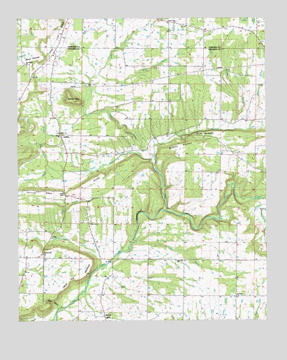
Barney, AR USGS Topographic Map
Click on map above to begin viewing in our Map Viewer.

This topographic map contains these locations and features:
Feature Name Type Latitude Longitude GNIS ID View Map
BarneyPopulated PlaceN35.2517°W92.2068°57331View Map
Barney Church of ChristChurchN35.2512°W92.2063°76103View Map
Barney School (historical)SchoolN35.2520°W92.2063°76104View Map
Beckette MountainSummitN35.3231°W92.1588°76276View Map
Brannan School (historical)SchoolN35.3476°W92.1735°62739View Map
Brewers School (historical)SchoolN35.2748°W92.1704°78911View Map
Brier BranchStreamN35.3290°W92.1410°46948View Map
Brown CemeteryCemeteryN35.2637°W92.1999°46995View Map
Buck BranchStreamN35.3520°W92.2099°47117View Map
Buffalo HumpSummitN35.3409°W92.2221°47159View Map
Cedar BranchStreamN35.2831°W92.1927°47568View Map
Cedar BranchStreamN35.2837°W92.2257°47569View Map
Cedar Hill ChurchChurchN35.2748°W92.1707°47616View Map
Cedar Point ChurchChurchN35.3734°W92.1704°47621View Map
Clear CreekStreamN35.2956°W92.1757°47831View Map
Devils BackboneRidgeN35.3273°W92.1568°48485View Map
EndersPopulated PlaceN35.3267°W92.2285°76877View Map
Fairview CreekStreamN35.3134°W92.2343°48975View Map
Fairview RidgeRidgeN35.3031°W92.2377°48977View Map
Ira's AirstripAirportN35.2791°W92.2400°2650770View Map
Irwin GapGapN35.3020°W92.2271°50527View Map
Ligon CreekStreamN35.3523°W92.2099°51163View Map
Mansfield BluffCliffN35.2940°W92.1904°51648View Map
Mortar CreekStreamN35.3181°W92.1815°77695View Map
Mortar Creek CemeteryCemeteryN35.3476°W92.2151°52227View Map
Mount Nebo ChurchChurchN35.2601°W92.1404°77725View Map
Mount PleasantSummitN35.3590°W92.2379°58403View Map
Mount Pleasant CemeteryCemeteryN35.3570°W92.2465°62857View Map
Mount Pleasant ChurchChurchN35.3567°W92.2463°52406View Map
New Hope Baptist ChurchChurchN35.3551°W92.1913°77825View Map
Nichols CreekStreamN35.3179°W92.1813°77850View Map
Pleasant Hill Methodist ChurchChurchN35.2779°W92.2377°78049View Map
Powell FordCrossingN35.2556°W92.2271°62883View Map
Shady Grove Church (historical)ChurchN35.3509°W92.1296°62904View Map
Strain BranchStreamN35.3290°W92.1332°55262View Map
Sulphur Springs Baptist ChurchChurchN35.3265°W92.2288°62916View Map
Township of BentonCivilN35.3204°W92.2283°66521View Map
Township of MountainCivilN35.3186°W92.1480°66534View Map
Webb HillSummitN35.3087°W92.2121°58841View Map
White Oak ChurchChurchN35.2901°W92.2140°56267View Map
White Oak CreekStreamN35.2720°W92.2104°78751View Map
White Oak MountainSummitN35.2695°W92.2163°56291View Map
Whiteoak BridgeBridgeN35.2745°W92.2038°62933View Map
Whiteoak School (historical)SchoolN35.2904°W92.2140°78926View Map
Wolf HollowValleyN35.2548°W92.2304°56493View Map

Note: Coordinates in the location and feature list above are referenced to NAD83 datum.


Copyright (C) 2008-2024 Ryan Niemi / Sunset Dynamics ... All Rights Reserved