TopoQuest Logo
Do you find TopoQuest useful?
Help keep TopoQuest running and adding new maps/features by donating!
Bitcoin:  19c7KJd3qBynnjoSw5npx9KScwjBe4ifkT
Litecoin:  LXs6TkuXGGXo1vDsWCkWVdjQX94eUKd6ui
Home View Maps Find Maps Find Places Resources & Links


Holt Mountain, New Mexico Topographic Map

USGS Map Title: Holt Mountain, NM
USGS Map MRC: 33108C7
DRG (GeoTIFF) Download: o33108c7.tif


Neighboring USGS Topographic Map Quads:


  Alma, NM  
33108D8
 

  Mogollon, NM  
33108D7
 

  Bearwallow Mountain, NM  
33108D6
 

  Glenwood, NM  
33108C8
 

  Holt Mountain, NM  
33108C7
 

  Grouse Mountain, NM  
33108C6
 

  Wilson Mountain, NM  
33108B8
 

  Moon Ranch, NM  
33108B7
 

  Rice Ranch, NM  
33108B6


Map MRC Location:

N34°
W109°
N34°
W108°
H8 H7 H6 H5 H4 H3 H2 H1
G8 G7 G6 G5 G4 G3 G2 G1
F8 F7 F6 F5 F4 F3 F2 F1
E8 E7 E6 E5 E4 E3 E2 E1
D8 D7 D6 D5 D4 D3 D2 D1
C8 C7 C6 C5 C4 C3 C2 C1
B8 B7 B6 B5 B4 B3 B2 B1
A8 A7 A6 A5 A4 A3 A2 A1
N33°
W109°
N33°
W108°

Holt Mountain, NM USGS 1:24K Topographic Map Preview:
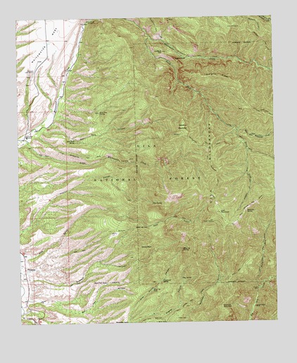
Holt Mountain, NM USGS Topographic Map
Click on map above to begin viewing in our Map Viewer.

This topographic map contains these locations and features:
Feature Name Type Latitude Longitude GNIS ID View Map
Allotment TankReservoirN33.2848°W108.8523°912717View Map
Angels RoostSummitN33.3581°W108.7984°903167View Map
Black Tail TankReservoirN33.2663°W108.8337°886457View Map
Blue Jay SpringSpringN33.2800°W108.7962°903942View Map
Burns SpringSpringN33.3090°W108.8265°912803View Map
Cardinal GapSummitN33.3612°W108.8042°904775View Map
Cave SpringSpringN33.2991°W108.8105°904852View Map
Cave TankReservoirN33.3373°W108.8231°912728View Map
CCC TankReservoirN33.3022°W108.8659°912715View Map
Chipmunk SpringSpringN33.2670°W108.8064°905116View Map
Clay SpringSpringN33.2684°W108.7969°905191View Map
Deer Park CanyonValleyN33.3251°W108.8712°905700View Map
Deer Park Canyon ProspectsMineN33.3334°W108.8340°917300View Map
Deer Park SpringSpringN33.3255°W108.8480°905701View Map
Deloche TrailTrailN33.3648°W108.7553°905715View Map
Dripping Gold SpringSpringN33.3703°W108.8023°912727View Map
East Fork Whitewater CreekStreamN33.3278°W108.7684°905973View Map
Fence TankReservoirN33.2594°W108.8398°912705View Map
Glenwood Ranger DistrictForestN33.3323°W108.8526°2038482View Map
Glenwood-Catron County AirportAirportN33.3573°W108.8654°912722View Map
Goat Corral Canyon ProspectMineN33.2667°W108.8006°917308View Map
Goat SpringSpringN33.2651°W108.8092°912702View Map
Goat SpringSpringN33.3392°W108.8353°912725View Map
Goat Water TankReservoirN33.3370°W108.8373°912724View Map
Goddard Canyon ProspectsMineN33.2690°W108.8320°917309View Map
Gold HillSummitN33.2890°W108.8148°906610View Map
Goodard TankReservoirN33.2743°W108.8373°912711View Map
Hardscrabble ProspectsMineN33.2501°W108.7506°917313View Map
Holt Apache TrailTrailN33.2978°W108.7631°907036View Map
Holt Canyon ProspectsMineN33.3001°W108.7839°916804View Map
Holt Guard StationLocaleN33.2909°W108.7809°907037View Map
Holt MountainSummitN33.2951°W108.7773°907039View Map
Holt Mountain TrailTrailN33.3106°W108.7787°907040View Map
Holt SpringSpringN33.2951°W108.7873°912708View Map
Holt TunnelMineN33.2834°W108.7839°916805View Map
Huckleberry Spar MineMineN33.2915°W108.8298°917239View Map
Hunter Water TankReservoirN33.3298°W108.8331°912726View Map
Hunters TankReservoirN33.3474°W108.8221°912729View Map
Ida Bell and Bessie Number One ProspectMineN33.3501°W108.8173°917479View Map
Independence MineMineN33.2562°W108.7612°907188View Map
Iron Bar ProspectMineN33.3740°W108.8015°917480View Map
Iron Clad ClaimsMineN33.2834°W108.7839°917481View Map
Iron Group MineMineN33.3667°W108.7840°921065View Map
Johnson CabinLocaleN33.2634°W108.7595°907400View Map
Kordic ClaimMineN33.3667°W108.7673°917142View Map
Lauderbaugh ProspectMineN33.3501°W108.8006°917485View Map
Liberty Bell Number One ClaimMineN33.2834°W108.8340°916799View Map
Little Spar ProspectsMineN33.3001°W108.8006°917488View Map
Little Whitewater CreekStreamN33.3251°W108.8715°908069View Map
Little Whitewater TrailTrailN33.3178°W108.8445°908070View Map
Lone Pine SpringSpringN33.3362°W108.8356°908145View Map
Lone Star Group MineMineN33.2834°W108.8006°917136View Map
Lone Star Number Seven ProspectMineN33.3001°W108.7756°921067View Map
Lower Seridan SpringSpringN33.2537°W108.7939°912704View Map
Lower TankReservoirN33.3318°W108.8581°912718View Map
Lucky TankSpringN33.2867°W108.8284°912710View Map
M T TankReservoirN33.2640°W108.8286°908329View Map
Middle TankReservoirN33.3070°W108.8468°912720View Map
Midnight SpringSpringN33.2952°W108.7649°908730View Map
Moose Group MineMineN33.3334°W108.8340°916786View Map
Morning Star ProspectsMineN33.2834°W108.8006°916787View Map
Muddy TankReservoirN33.2813°W108.8657°912712View Map
Nabours MountainSummitN33.3317°W108.7945°909004View Map
North Fork Dry CreekStreamN33.2631°W108.7595°909144View Map
North Fork TrailTrailN33.2773°W108.7576°909156View Map
Old Uncle John MineMineN33.2501°W108.7506°916782View Map
PDQ TankReservoirN33.2513°W108.8417°912706View Map
PleasantonPopulated PlaceN33.2723°W108.8728°909756View Map
Pleasanton Post Office (historical)Post OfficeN33.2723°W108.8728°937790View Map
Red Colt Canyon ProspectsMineN33.2667°W108.8173°917047View Map
Red Colt Canyon WellWellN33.2576°W108.8567°912714View Map
Red ShaftMineN33.2876°W108.8240°910080View Map
Red Shaft PropsectMineN33.2881°W108.8284°917048View Map
Red TankReservoirN33.2785°W108.8215°912707View Map
Schoolhouse Canyon WellWellN33.2578°W108.8581°912713View Map
Sheldon Canon WindmillLocaleN33.2951°W108.8609°912716View Map
Shelton Canyon ProspectsMineN33.3084°W108.8340°917260View Map
Sheridan MountainSummitN33.2567°W108.7773°911009View Map
Sheridan TankReservoirN33.2583°W108.7979°912703View Map
Silted Up TankReservoirN33.2637°W108.8112°911056View Map
Skeleton RidgeRidgeN33.3509°W108.7767°911112View Map
South Fork TrailTrailN33.3306°W108.7739°911255View Map
South Fork Whitewater CreekStreamN33.3665°W108.8098°911257View Map
Straight Up TrailTrailN33.3059°W108.7626°911448View Map
Sunshine TankReservoirN33.2584°W108.8139°912701View Map
Tennessee MeadowFlatN33.3301°W108.7562°912732View Map
The Catwalk Historical MarkerParkN33.3737°W108.8403°932248View Map
The Lime Kiln MineMineN33.3667°W108.7840°921066View Map
Thunderhead WorkingsMineN33.2834°W108.7506°917037View Map
West Side TankReservoirN33.3718°W108.8640°912721View Map
White Water Mesa TankReservoirN33.3521°W108.8696°912723View Map
Whitetail SpringSpringN33.2695°W108.7784°912709View Map
Whitewater CampgroundLocaleN33.3737°W108.8403°912347View Map
Whitewater MesaBenchN33.3656°W108.8598°912355View Map
Whitewater Mesa Ranch AirportAirportN33.3628°W108.8636°936957View Map
Whitewater TrailTrailN33.3590°W108.7890°912357View Map
Wilcox ClaimsMineN33.2834°W108.8006°917140View Map
Wilcox PeakPopulated PlaceN33.2809°W108.8165°912364View Map
Wilcox Peak ProspectsMineN33.2834°W108.8006°917141View Map
Wilcox ProspectsMineN33.2751°W108.8089°916788View Map
York TankReservoirN33.3090°W108.8599°912719View Map

Note: Coordinates in the location and feature list above are referenced to NAD83 datum.


Copyright (C) 2008-2024 Ryan Niemi / Sunset Dynamics ... All Rights Reserved