TopoQuest Logo
Do you find TopoQuest useful?
Help keep TopoQuest running and adding new maps/features by donating!
Bitcoin:  19c7KJd3qBynnjoSw5npx9KScwjBe4ifkT
Litecoin:  LXs6TkuXGGXo1vDsWCkWVdjQX94eUKd6ui
Home View Maps Find Maps Find Places Resources & Links


Hontubby, Oklahoma Topographic Map

USGS Map Title: Hontubby, OK
USGS Map MRC: 34094G5
DRG (GeoTIFF) Download: o34094g5.tif


Neighboring USGS Topographic Map Quads:


  Wister, OK  
34094H6
 

  Heavener, OK  
34094H5
 

  Bates, AR  
34094H4
 

  Hodgen, OK  
34094G6
 

  Hontubby, OK  
34094G5
 

  Loving, OK  
34094G4
 

  Big Cedar, OK  
34094F6
 

  Page, OK  
34094F5
 

  Mountain Fork, AR  
34094F4


Map MRC Location:

N35°
W95°
N35°
W94°
H8 H7 H6 H5 H4 H3 H2 H1
G8 G7 G6 G5 G4 G3 G2 G1
F8 F7 F6 F5 F4 F3 F2 F1
E8 E7 E6 E5 E4 E3 E2 E1
D8 D7 D6 D5 D4 D3 D2 D1
C8 C7 C6 C5 C4 C3 C2 C1
B8 B7 B6 B5 B4 B3 B2 B1
A8 A7 A6 A5 A4 A3 A2 A1
N34°
W95°
N34°
W94°

Hontubby, OK USGS 1:24K Topographic Map Preview:
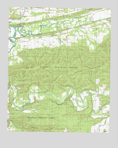
Hontubby, OK USGS Topographic Map
Click on map above to begin viewing in our Map Viewer.

This topographic map contains these locations and features:
Feature Name Type Latitude Longitude GNIS ID View Map
Big Creek CemeteryCemeteryN34.7711°W94.5011°1777536View Map
Big Creek ChurchChurchN34.7693°W94.5172°1777537View Map
Black ForkStreamN34.8554°W94.6194°1101289View Map
Bushman CreekStreamN34.7765°W94.5388°1101324View Map
Cedar CreekStreamN34.7904°W94.5249°1101341View Map
ForresterPopulated PlaceN34.8723°W94.5266°1101420View Map
Frizzell BranchStreamN34.7737°W94.6102°1101417View Map
Frizzell BranchStreamN34.7734°W94.6102°1777534View Map
Haw CreekPopulated PlaceN34.7726°W94.5094°1101449View Map
Haw CreekStreamN34.7899°W94.5247°1101450View Map
Haw Creek Rural Fire DepartmentBuildingN34.7705°W94.5090°2657371View Map
HeavenerLocaleN34.8712°W94.6030°1777533View Map
HontubbyPopulated PlaceN34.8504°W94.5661°1101472View Map
Hontubby CemeteryCemeteryN34.8542°W94.5639°2711785View Map
Hontubby CreekStreamN34.8587°W94.5672°1101473View Map
Hontubby FallsFallsN34.8559°W94.5858°1101474View Map
Jesus Name ChurchChurchN34.7754°W94.5211°1777535View Map
Loving CemeteryCemeteryN34.8618°W94.5002°1101525View Map
McMurtery BranchStreamN34.7559°W94.6188°1101538View Map
Oil BranchStreamN34.8570°W94.5794°1101571View Map
PetrosPopulated PlaceN34.8695°W94.6088°1101579View Map
Standpipe HillSummitN34.8570°W94.6133°1101673View Map
StappPopulated PlaceN34.7551°W94.6238°1101674View Map
Sugar CreekStreamN34.8665°W94.5327°1101679View Map

Note: Coordinates in the location and feature list above are referenced to NAD83 datum.


Copyright (C) 2008-2024 Ryan Niemi / Sunset Dynamics ... All Rights Reserved