TopoQuest Logo
Do you find TopoQuest useful?
Help keep TopoQuest running and adding new maps/features by donating!
Bitcoin:  19c7KJd3qBynnjoSw5npx9KScwjBe4ifkT
Litecoin:  LXs6TkuXGGXo1vDsWCkWVdjQX94eUKd6ui
Home View Maps Find Maps Find Places Resources & Links


Hooversville, Pennsylvania Topographic Map

USGS Map Title: Hooversville, PA
USGS Map MRC: 40078B8
DRG (GeoTIFF) Download: o40078b8.tif


Neighboring USGS Topographic Map Quads:


  Rachelwood, PA  
40079C1
 

  Johnstown, PA  
40078C8
 

  Geistown, PA  
40078C7
 

  Boswell, PA  
40079B1
 

  Hooversville, PA  
40078B8
 

  Windber, PA  
40078B7
 

  Somerset, PA  
40079A1
 

  Stoystown, PA  
40078A8
 

  Central City, PA  
40078A7


Map MRC Location:

N41°
W79°
N41°
W78°
H8 H7 H6 H5 H4 H3 H2 H1
G8 G7 G6 G5 G4 G3 G2 G1
F8 F7 F6 F5 F4 F3 F2 F1
E8 E7 E6 E5 E4 E3 E2 E1
D8 D7 D6 D5 D4 D3 D2 D1
C8 C7 C6 C5 C4 C3 C2 C1
B8 B7 B6 B5 B4 B3 B2 B1
A8 A7 A6 A5 A4 A3 A2 A1
N40°
W79°
N40°
W78°

Hooversville, PA USGS 1:24K Topographic Map Preview:
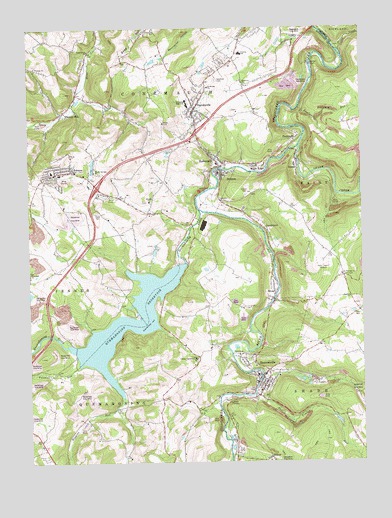
Hooversville, PA USGS Topographic Map
Click on map above to begin viewing in our Map Viewer.

This topographic map contains these locations and features:
Feature Name Type Latitude Longitude GNIS ID View Map
Bens Creek ChurchChurchN40.2437°W78.9770°1169265View Map
BensonPopulated PlaceN40.2084°W78.9278°1169269View Map
BloughPopulated PlaceN40.1717°W78.9081°1169862View Map
Blough ChurchChurchN40.2004°W78.9542°1169863View Map
Blough SchoolSchoolN40.1592°W78.9834°1206120View Map
BorderLocaleN40.2404°W78.8889°1206114View Map
Borough of BensonCivilN40.2027°W78.9293°1215581View Map
Borough of HooversvilleCivilN40.1505°W78.9133°1215588View Map
Camp HarmonyLocaleN40.1551°W78.9367°1171016View Map
Central SchoolSchoolN40.2429°W78.9186°1171496View Map
Conemaugh Township Emergency Medical Services Substation - Station 640BuildingN40.2083°W78.9894°2719655View Map
Custer CemeteryCemeteryN40.2020°W78.9181°1172871View Map
DavidsvillePopulated PlaceN40.2270°W78.9364°1172983View Map
Davidsville Census Designated PlaceCensusN40.2348°W78.9356°2389396View Map
Davidsville Post OfficePost OfficeN40.2259°W78.9374°2768338View Map
Fallen Timber RunStreamN40.1454°W78.9153°1174585View Map
FoustwellPopulated PlaceN40.2181°W78.8995°1175078View Map
Higgins RunStreamN40.1437°W78.9647°1177000View Map
HiyasotaLocaleN40.2029°W78.9720°1212296View Map
HollsopplePopulated PlaceN40.2126°W78.9289°1177222View Map
Hollsopple Post OfficePost OfficeN40.2083°W78.9278°2779841View Map
Hollsopple Volunteer Fire Department - Station 616BuildingN40.2090°W78.9275°2644821View Map
HooversvillePopulated PlaceN40.1470°W78.9120°1177374View Map
Hooversville Borough Police DepartmentBuildingN40.1502°W78.9145°2781080View Map
Hooversville Emergency Medical ServicesBuildingN40.1503°W78.9146°2719654View Map
Hooversville Post OfficePost OfficeN40.1456°W78.9135°2772748View Map
Hooversville Post Office (historical)Post OfficeN40.1473°W78.9117°1214335View Map
Hooversville Volunteer Fire Department - Station 614BuildingN40.1502°W78.9146°2645323View Map
Hopewell ChurchChurchN40.1798°W78.9997°1177399View Map
Horner ChurchChurchN40.1787°W78.9992°1206121View Map
Houston School (historical)SchoolN40.1609°W78.8867°1206118View Map
JeromePopulated PlaceN40.2090°W78.9836°1178051View Map
Jerome Census Designated PlaceCensusN40.2135°W78.9809°2389985View Map
Jerome JunctionPopulated PlaceN40.2009°W78.9314°1206117View Map
Jerome Post OfficePost OfficeN40.2081°W78.9903°2779935View Map
Jerome Volunteer Fire Company - Station 631BuildingN40.2082°W78.9895°2645215View Map
Johnstown Christian SchoolSchoolN40.2496°W78.9525°1178133View Map
Kaufman CemeteryCemeteryN40.2353°W78.9289°1178254View Map
Kaufman ChurchChurchN40.2340°W78.9172°1178255View Map
Kaufman RunStreamN40.2270°W78.8975°1178257View Map
Kaufman School (historical)SchoolN40.2412°W78.9225°1206123View Map
Keafer SchoolSchoolN40.2492°W78.9734°1206122View Map
LandstreetPopulated PlaceN40.1915°W78.9103°1178859View Map
Maple RidgePopulated PlaceN40.2109°W78.9134°1180357View Map
Maple Springs ChurchChurchN40.2087°W78.9745°1180367View Map
Number 38LocaleN40.2076°W78.8895°1206116View Map
Ober SchoolSchoolN40.1409°W78.9667°1206119View Map
Paint CreekLocaleN40.2451°W78.8839°1206115View Map
Paint CreekStreamN40.2448°W78.8845°1183197View Map
Quemahoning CreekStreamN40.1981°W78.9350°1184548View Map
Quemahoning DamDamN40.1822°W78.9406°1194606View Map
Quemahoning ReservoirReservoirN40.1657°W78.9629°1184549View Map
Saint Davids ChurchChurchN40.2331°W78.9314°1185904View Map
Saint Thomas ChurchChurchN40.1790°W78.8822°1186750View Map
SeanorPopulated PlaceN40.2120°W78.8984°1187197View Map
Shade CreekStreamN40.2162°W78.8981°1193319View Map
Shaffer ChurchChurchN40.1717°W78.8792°1187325View Map
Somerset Township High SchoolSchoolN40.2284°W78.9400°1209106View Map
Southern Alleghenies LandfillLocaleN40.2333°W78.9019°2725981View Map
Stanton MillsLocaleN40.1584°W78.9803°1206862View Map
Thomas ChurchChurchN40.2387°W78.9970°1189477View Map
Thomas MillPopulated PlaceN40.2259°W78.9872°1189485View Map
Township of ConemaughCivilN40.2431°W78.9660°1217046View Map
Twomile RunStreamN40.1534°W78.9820°1190030View Map
WJAC-AM (Johnstown)TowerN40.1817°W78.8886°1200379View Map

Note: Coordinates in the location and feature list above are referenced to NAD83 datum.


Copyright (C) 2008-2024 Ryan Niemi / Sunset Dynamics ... All Rights Reserved