TopoQuest Logo
Do you find TopoQuest useful?
Help keep TopoQuest running and adding new maps/features by donating!
Bitcoin:  19c7KJd3qBynnjoSw5npx9KScwjBe4ifkT
Litecoin:  LXs6TkuXGGXo1vDsWCkWVdjQX94eUKd6ui
Home View Maps Find Maps Find Places Resources & Links


Central City, Pennsylvania Topographic Map

USGS Map Title: Central City, PA
USGS Map MRC: 40078A7
DRG (GeoTIFF) Download: o40078a7.tif


Neighboring USGS Topographic Map Quads:


  Hooversville, PA  
40078B8
 

  Windber, PA  
40078B7
 

  Ogletown, PA  
40078B6
 

  Stoystown, PA  
40078A8
 

  Central City, PA  
40078A7
 

  Schellsburg, PA  
40078A6
 

  Berlin, PA  
39078H8
 

  New Baltimore, PA  
39078H7
 

  Buffalo Mills, PA  
39078H6


Map MRC Location:

N41°
W79°
N41°
W78°
H8 H7 H6 H5 H4 H3 H2 H1
G8 G7 G6 G5 G4 G3 G2 G1
F8 F7 F6 F5 F4 F3 F2 F1
E8 E7 E6 E5 E4 E3 E2 E1
D8 D7 D6 D5 D4 D3 D2 D1
C8 C7 C6 C5 C4 C3 C2 C1
B8 B7 B6 B5 B4 B3 B2 B1
A8 A7 A6 A5 A4 A3 A2 A1
N40°
W79°
N40°
W78°

Central City, PA USGS 1:24K Topographic Map Preview:
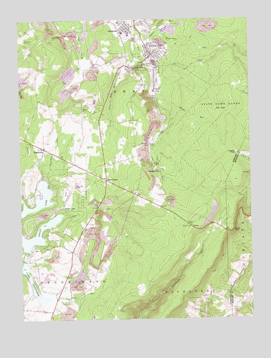
Central City, PA USGS Topographic Map
Click on map above to begin viewing in our Map Viewer.

This topographic map contains these locations and features:
Feature Name Type Latitude Longitude GNIS ID View Map
Beaverdam RunStreamN40.1195°W78.7967°1169065View Map
BoonePopulated PlaceN40.0092°W78.8484°1203126View Map
Boone RunStreamN40.0098°W78.8564°1169993View Map
Borough of Central CityCivilN40.1096°W78.8043°1215585View Map
Borough of Indian LakeCivilN40.0446°W78.8603°1215589View Map
BuckstownPopulated PlaceN40.0712°W78.8617°1170584View Map
Buckstown SchoolSchoolN40.0806°W78.8697°1206661View Map
CairnbrookPopulated PlaceN40.1190°W78.8181°1170870View Map
Cairnbrook Census Designated PlaceCensusN40.1246°W78.8189°2634208View Map
Cairnbrook Post OfficePost OfficeN40.1218°W78.8138°2779697View Map
Calendars RunStreamN40.0642°W78.8614°1170880View Map
Central CityPopulated PlaceN40.1106°W78.8020°1171481View Map
Central City Fire Department - Station 626BuildingN40.1087°W78.8049°2645850View Map
Central City Post OfficePost OfficeN40.1071°W78.8072°2779840View Map
Central City QuarryMineN40.1203°W78.7900°2724969View Map
Central City VistaSummitN40.0373°W78.7636°1201875View Map
Clear RunStreamN40.0440°W78.8514°1171967View Map
Coal RunStreamN40.0906°W78.7945°1172064View Map
Dubstardt School (historical)SchoolN40.0534°W78.8731°1205353View Map
Fairview School (historical)SchoolN40.0934°W78.8381°1205354View Map
Fraziers PassLocaleN40.0692°W78.7570°1175188View Map
GahagenPopulated PlaceN40.0623°W78.8020°1175377View Map
Grand ViewPopulated PlaceN40.0376°W78.7581°1203707View Map
Huksin 3 4 and 6 Mines StationLocaleN40.0679°W78.8036°1212303View Map
Indian LakePopulated PlaceN40.0467°W78.8522°1192663View Map
Indian LakeReservoirN40.0348°W78.8664°1192664View Map
Indian Lake Airpark (historical)AirportN40.0542°W78.8470°1193818View Map
Indian Lake DamDamN40.0275°W78.8713°1194496View Map
Lake StonycreekReservoirN40.0219°W78.8743°1193483View Map
Laurel RunStreamN40.1190°W78.8100°1179002View Map
Little Dark Shade CreekStreamN40.1145°W78.8095°1179520View Map
Miller School (historical)SchoolN40.0434°W78.8364°1205352View Map
Panther RunStreamN40.1009°W78.7975°1212323View Map
Reels CornersPopulated PlaceN40.0581°W78.8278°1184839View Map
Reitz 3 and 4 Mines StationLocaleN40.1062°W78.8003°1212304View Map
Ridge SchoolSchoolN40.1195°W78.8647°1205355View Map
Shade ChurchChurchN40.0873°W78.8400°1187288View Map
Shade Township Police DepartmentBuildingN40.1215°W78.8030°2781088View Map
Shingle RunStreamN40.0906°W78.7945°1187538View Map
Sinne Sawmill (historical)LocaleN40.1126°W78.7564°1205356View Map
State Game Lands Number 228ParkN40.0906°W78.7584°1188496View Map
Statler Hill Lookout TowerTowerN40.1167°W78.8672°1213371View Map
Township of ShadeCivilN40.1135°W78.8182°1217061View Map
WWZE-FM (Central City)TowerN40.1117°W78.8589°1200192View Map

Note: Coordinates in the location and feature list above are referenced to NAD83 datum.


Copyright (C) 2008-2025 Ryan Niemi / Sunset Dynamics ... All Rights Reserved