TopoQuest Logo
Do you find TopoQuest useful?
Help keep TopoQuest running and adding new maps/features by donating!
Bitcoin:  19c7KJd3qBynnjoSw5npx9KScwjBe4ifkT
Litecoin:  LXs6TkuXGGXo1vDsWCkWVdjQX94eUKd6ui
Home View Maps Find Maps Find Places Resources & Links


Hot Springs NE, Montana Topographic Map

USGS Map Title: Hot Springs NE, MT
USGS Map MRC: 47114F5
DRG (GeoTIFF) Download: o47114f5.tif


Neighboring USGS Topographic Map Quads:


  Mill Pocket Creek, MT  
47114G6
 

  Niarada, MT  
47114G5
 

  Irvine Lookout Tower, MT  
47114G4
 

  Lonepine, MT  
47114F6
 

  Hot Springs NE, MT  
47114F5
 

  Irvine Hill, MT  
47114F4
 

  Hot Springs, MT  
47114E6
 

  Markle Pass, MT  
47114E5
 

  Oliver Point, MT  
47114E4


Map MRC Location:

N48°
W115°
N48°
W114°
H8 H7 H6 H5 H4 H3 H2 H1
G8 G7 G6 G5 G4 G3 G2 G1
F8 F7 F6 F5 F4 F3 F2 F1
E8 E7 E6 E5 E4 E3 E2 E1
D8 D7 D6 D5 D4 D3 D2 D1
C8 C7 C6 C5 C4 C3 C2 C1
B8 B7 B6 B5 B4 B3 B2 B1
A8 A7 A6 A5 A4 A3 A2 A1
N47°
W115°
N47°
W114°

Hot Springs NE, MT USGS 1:24K Topographic Map Preview:
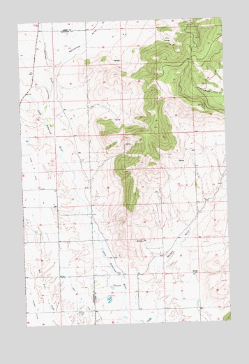
Hot Springs NE, MT USGS Topographic Map
Click on map above to begin viewing in our Map Viewer.

This topographic map contains these locations and features:
Feature Name Type Latitude Longitude GNIS ID View Map
22N23W07BBD_01 WellWellN47.6858°W114.6007°824525View Map
22N23W07BBD_02 WellWellN47.6863°W114.6007°824526View Map
22N23W07DBD_01 WellWellN47.6780°W114.5899°824470View Map
22N23W15CDDD01 WellWellN47.6602°W114.5399°824374View Map
22N23W15DCDC01 WellWellN47.6599°W114.5274°824370View Map
22N23W17BBC_01 WellWellN47.6708°W114.5824°824432View Map
22N23W17BBDD01 WellWellN47.6702°W114.5793°824429View Map
22N23W17BCB_01 WellWellN47.6685°W114.5826°824414View Map
22N23W17CBB_01 WellWellN47.6666°W114.5832°824398View Map
22N23W17CDB_01 WellWellN47.6624°W114.5779°824381View Map
22N23W18ACA_01 WellWellN47.6702°W114.5893°824430View Map
22N23W18BBB_01 WellWellN47.6735°W114.6037°824449View Map
22N23W18DDA_01 WellWellN47.6624°W114.5843°824382View Map
22N23W19______ WellWellN47.6516°W114.5843°824317View Map
22N23W19CBD_01 WellWellN47.6488°W114.6024°824294View Map
22N23W19DAA_01 WellWellN47.6516°W114.5846°824318View Map
22N23W20BAAD01 WellWellN47.6591°W114.5749°824366View Map
22N23W20BCCB01 WellWellN47.6558°W114.5826°824344View Map
22N23W20CDBC01 WellWellN47.6469°W114.5774°824279View Map
22N23W20DCD_01 WellWellN47.6458°W114.5699°824272View Map
22N23W20DDC_01 WellWellN47.6458°W114.5671°824271View Map
22N23W28BADD01 WellWellN47.6394°W114.5521°824215View Map
22N23W28CAC_01 WellWellN47.6358°W114.5551°824192View Map
22N23W28CBB_01 WellWellN47.6360°W114.5601°824194View Map
22N23W28CBD_01 WellWellN47.6352°W114.5582°824191View Map
22N23W29AAD_01 WellWellN47.6430°W114.5646°824248View Map
22N23W29ACAB01 WellWellN47.6402°W114.5712°824229View Map
22N23W29ACB_01 WellWellN47.6410°W114.5721°824239View Map
22N23W29BAA_01 WellWellN47.6441°W114.5754°824256View Map
22N23W29BADD01 WellWellN47.6422°W114.5729°824247View Map
22N23W29CACA01 WellWellN47.6358°W114.5757°824193View Map
22N23W29CCCC01 WellWellN47.6313°W114.5826°824162View Map
22N23W30DBCD01 WellWellN47.6347°W114.5929°824188View Map
22N23W32BCB_01 WellWellN47.6263°W114.5829°824129View Map
22N23W33BAB_01 WellWellN47.6299°W114.5562°824154View Map
22N23W33BDA_01 WellWellN47.6263°W114.5529°824128View Map
22N23W34AAA_01 WellWellN47.6294°W114.5201°824145View Map
22N24W01BDCC01 WellWellN47.6955°W114.6201°824568View Map
22N24W01CBD_01 WellWellN47.6924°W114.6226°824558View Map
22N24W12ACCC01 WellWellN47.6813°W114.6140°824487View Map
22N24W13BCB_01 WellWellN47.6697°W114.6246°824424View Map
22N24W13DAD_01 WellWellN47.6630°W114.6051°824385View Map
22N24W24ABBD01 WellWellN47.6588°W114.6126°824365View Map
22N24W24ADA_01 WellWellN47.6541°W114.6051°824337View Map
22N24W36BBB_01 WellWellN47.6297°W114.6246°824151View Map
23N24W24CAC_01 WellWellN47.7363°W114.6193°824748View Map
23N24W25DAD_01 WellWellN47.7219°W114.6060°824687View Map
23N24W35BAA_02 WellWellN47.7094°W114.6168°824643View Map
23N24W36CAA_01 WellWellN47.7088°W114.6165°824639View Map
Aqua DamDamN47.6349°W114.5743°798728View Map
Camas B CanalCanalN47.6966°W114.6232°780802View Map
Garcon GulchValleyN47.6338°W114.5568°771700View Map
Marine DamDamN47.6266°W114.5376°798729View Map
Rattlesnake GulchValleyN47.7319°W114.6037°775590View Map
Sullivan CreekStreamN47.7158°W114.6093°791650View Map
Wildhorse Hot SpringsLocaleN47.6363°W114.5765°769529View Map

Note: Coordinates in the location and feature list above are referenced to NAD83 datum.


Copyright (C) 2008-2025 Ryan Niemi / Sunset Dynamics ... All Rights Reserved