TopoQuest Logo
Do you find TopoQuest useful?
Help keep TopoQuest running and adding new maps/features by donating!
Bitcoin:  19c7KJd3qBynnjoSw5npx9KScwjBe4ifkT
Litecoin:  LXs6TkuXGGXo1vDsWCkWVdjQX94eUKd6ui
Home View Maps Find Maps Find Places Resources & Links


Howelton, Alabama Topographic Map

USGS Map Title: Howelton, AL
USGS Map MRC: 34086A2
DRG (GeoTIFF) Download: o34086a2.tif


Neighboring USGS Topographic Map Quads:


  Douglas, AL  
34086B3
 

  Boaz, AL  
34086B2
 

  Rodentown, AL  
34086B1
 

  Altoona, AL  
34086A3
 

  Howelton, AL  
34086A2
 

  Gadsden West, AL  
34086A1
 

  Hyatt Gap, AL  
33086H3
 

  Steele, AL  
33086H2
 

  Dunaway Mountain, AL  
33086H1


Map MRC Location:

N35°
W87°
N35°
W86°
H8 H7 H6 H5 H4 H3 H2 H1
G8 G7 G6 G5 G4 G3 G2 G1
F8 F7 F6 F5 F4 F3 F2 F1
E8 E7 E6 E5 E4 E3 E2 E1
D8 D7 D6 D5 D4 D3 D2 D1
C8 C7 C6 C5 C4 C3 C2 C1
B8 B7 B6 B5 B4 B3 B2 B1
A8 A7 A6 A5 A4 A3 A2 A1
N34°
W87°
N34°
W86°

Howelton, AL USGS 1:24K Topographic Map Preview:
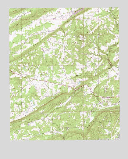
Howelton, AL USGS Topographic Map
Click on map above to begin viewing in our Map Viewer.

This topographic map contains these locations and features:
Feature Name Type Latitude Longitude GNIS ID View Map
Armstrong CemeteryCemeteryN34.0965°W86.1866°113222View Map
Armstrong CreekStreamN34.0984°W86.1875°113225View Map
AuroraPopulated PlaceN34.1168°W86.1925°157881View Map
Aurora LakeReservoirN34.1198°W86.1773°113281View Map
Aurora LakeReservoirN34.1247°W86.1646°131943View Map
Aurora Missionary Baptist ChurchChurchN34.1207°W86.1922°140449View Map
Benson (historical)Populated PlaceN34.0473°W86.1583°149021View Map
Brasher CemeteryCemeteryN34.0145°W86.1844°114847View Map
Brasher SpringSpringN34.0118°W86.1851°114849View Map
Brasher Spring CampLocaleN34.0112°W86.1844°157899View Map
Bristow Cove Census Designated PlaceCensusN34.1092°W86.2410°2582664View Map
Bristows Creek Watershed Dam Number 1DamN34.1184°W86.1750°131944View Map
Brown CreekStreamN34.0293°W86.1441°114992View Map
Buffington Memorial Methodist ChurchChurchN34.1168°W86.1905°140472View Map
Bull HollowValleyN34.0237°W86.2097°115179View Map
Carnes CemeteryCemeteryN34.0456°W86.1580°149039View Map
Carnes Chapel Congregational Methodist ChurchChurchN34.0462°W86.1586°115630View Map
Clear Creek ChurchChurchN34.0104°W86.1847°140499View Map
Clear Creek Methodist ChurchChurchN34.0104°W86.1864°140500View Map
Conn CemeteryCemeteryN34.0090°W86.1955°116513View Map
Dillard CemeteryCemeteryN34.0354°W86.1894°117287View Map
EgyptPopulated PlaceN34.0737°W86.1558°117885View Map
Egypt Census Designated PlaceCensusN34.0759°W86.1651°2582672View Map
Egypt Volunteer Fire DepartmentBuildingN34.0665°W86.1546°2683472View Map
Fairview Cumberland Methodist ChurchChurchN34.1032°W86.2058°118148View Map
Faith Tabernacle ChurchChurchN34.0048°W86.1372°140544View Map
Friendship Baptist ChurchChurchN34.0340°W86.2358°118702View Map
Gaines Chapel Methodist Church (historical)ChurchN34.0007°W86.1378°149053View Map
Gallant Census Designated PlaceCensusN34.0013°W86.2304°2582676View Map
Gallant Road Independent Baptist ChurchChurchN34.0076°W86.1989°140581View Map
Glassco LakeReservoirN34.0542°W86.1707°131927View Map
Glassco Lake DamDamN34.0551°W86.1700°131926View Map
Greasy CoveValleyN34.0445°W86.1625°164673View Map
Gregory GapGapN34.1057°W86.1916°140605View Map
HarrisvillePopulated PlaceN34.0495°W86.2347°140610View Map
Horsepen BranchStreamN34.0768°W86.1383°120418View Map
HoweltonPopulated PlaceN34.0559°W86.1836°120485View Map
Howelton CemeteryCemeteryN34.0506°W86.1775°120486View Map
Howelton Methodist ChurchChurchN34.0565°W86.1800°140624View Map
Howelton School (historical)SchoolN34.0565°W86.1805°149066View Map
IvaleePopulated PlaceN34.0345°W86.1453°120722View Map
Ivalee Baptist ChurchChurchN34.0357°W86.1439°140627View Map
Ivalee CemeteryCemeteryN34.0481°W86.1427°164230View Map
Ivalee Census Designated PlaceCensusN34.0372°W86.1472°2582684View Map
Ivalee Elementary SchoolSchoolN34.0359°W86.1253°165456View Map
Ivalee Fire DepartmentBuildingN34.0366°W86.1268°2682842View Map
Lee CemeteryCemeteryN34.0143°W86.1686°121464View Map
Lemon HollowValleyN34.0007°W86.1486°149074View Map
LittletonPopulated PlaceN34.0670°W86.1330°121921View Map
MaysPopulated PlaceN34.0987°W86.1861°149078View Map
Morton Chapel CemeteryCemeteryN34.0662°W86.2464°149089View Map
Morton Chapel United Methodist ChurchChurchN34.0640°W86.2458°164081View Map
Mortons School (historical)SchoolN34.0640°W86.2453°149090View Map
Mount Olive Missionary Baptist ChurchChurchN34.0562°W86.2153°123321View Map
Mount Pleasant Missionary Baptist ChurchChurchN34.0698°W86.1622°152501View Map
New Union Aurora Volunteer Fire Department Station 2BuildingN34.1172°W86.1937°2683201View Map
New Welcome Baptist ChurchChurchN34.0776°W86.1533°152683View Map
Pine View ChurchChurchN34.0857°W86.2055°124846View Map
Pleasant ValleyPopulated PlaceN34.0015°W86.1272°149109View Map
Pleasant Valley ChurchChurchN34.0004°W86.1269°125050View Map
Pole CreekStreamN34.0357°W86.2461°125092View Map
Red Hill CemeteryCemeteryN34.0376°W86.1397°140688View Map
Red Hill Methodist ChurchChurchN34.0368°W86.1397°153118View Map
Rocky HollowValleyN34.0059°W86.1891°125862View Map
Shady GrovePopulated PlaceN34.1140°W86.1569°149116View Map
Shady Grove Missionary Baptist ChurchChurchN34.1137°W86.1566°153392View Map
Shahan SpringSpringN34.0459°W86.1561°140713View Map
Sheffield GapGapN34.0712°W86.1347°140714View Map
Stanfield (historical)Populated PlaceN34.0126°W86.1680°140737View Map
Thrasher School (historical)SchoolN34.0501°W86.2044°149127View Map
Vaughns Grove School (historical)SchoolN34.0759°W86.1539°149130View Map
Wade CreekStreamN34.1095°W86.1980°128486View Map
Walker HollowValleyN34.0020°W86.1355°128523View Map
Walker MountainSummitN34.1037°W86.1536°149131View Map
Webb CemeteryCemeteryN34.0920°W86.1500°140767View Map
Webb CreekStreamN34.0807°W86.1383°128683View Map

Note: Coordinates in the location and feature list above are referenced to NAD83 datum.


Copyright (C) 2008-2025 Ryan Niemi / Sunset Dynamics ... All Rights Reserved