TopoQuest Logo
Do you find TopoQuest useful?
Help keep TopoQuest running and adding new maps/features by donating!
Bitcoin:  19c7KJd3qBynnjoSw5npx9KScwjBe4ifkT
Litecoin:  LXs6TkuXGGXo1vDsWCkWVdjQX94eUKd6ui
Home View Maps Find Maps Find Places Resources & Links


Hyatt Gap, Alabama Topographic Map

USGS Map Title: Hyatt Gap, AL
USGS Map MRC: 33086H3
DRG (GeoTIFF) Download: o33086h3.tif


Neighboring USGS Topographic Map Quads:


  Clarence, AL  
34086A4
 

  Altoona, AL  
34086A3
 

  Howelton, AL  
34086A2
 

  Oneonta, AL  
33086H4
 

  Hyatt Gap, AL  
33086H3
 

  Steele, AL  
33086H2
 

  Springville, AL  
33086G4
 

  Ashville, AL  
33086G3
 

  Cox Gap, AL  
33086G2


Map MRC Location:

N34°
W87°
N34°
W86°
H8 H7 H6 H5 H4 H3 H2 H1
G8 G7 G6 G5 G4 G3 G2 G1
F8 F7 F6 F5 F4 F3 F2 F1
E8 E7 E6 E5 E4 E3 E2 E1
D8 D7 D6 D5 D4 D3 D2 D1
C8 C7 C6 C5 C4 C3 C2 C1
B8 B7 B6 B5 B4 B3 B2 B1
A8 A7 A6 A5 A4 A3 A2 A1
N33°
W87°
N33°
W86°

Hyatt Gap, AL USGS 1:24K Topographic Map Preview:
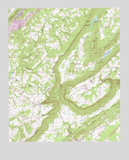
Hyatt Gap, AL USGS Topographic Map
Click on map above to begin viewing in our Map Viewer.

This topographic map contains these locations and features:
Feature Name Type Latitude Longitude GNIS ID View Map
Awtreys GapGapN33.8995°W86.3378°164544View Map
Bald HillSummitN33.9951°W86.2661°113397View Map
Battle GapGapN33.9490°W86.3228°164552View Map
Beason CoveValleyN33.8943°W86.2994°164553View Map
Beasons Mill (historical)LocaleN33.8779°W86.3039°1805485View Map
Bellews ChurchChurchN33.9070°W86.3541°135071View Map
Bethel ChurchChurchN33.9001°W86.3730°163847View Map
BethlehemPopulated PlaceN33.9820°W86.2661°149022View Map
Bethlehem CemeteryCemeteryN33.9823°W86.2666°140462View Map
Bethlehem ChurchChurchN33.9070°W86.2700°164558View Map
Bethlehem Independent Baptist ChurchChurchN33.9818°W86.2675°140463View Map
Bethlehem Primitive Baptist ChurchChurchN33.9815°W86.2658°114139View Map
Blount MountainRidgeN33.8815°W86.3483°164566View Map
Bunch CreekStreamN33.9770°W86.3416°115202View Map
Buzzard RockSummitN33.9865°W86.2875°115332View Map
Byrd CreekStreamN33.9887°W86.3289°115344View Map
Camp SumatangaLocaleN33.9487°W86.2730°164589View Map
Cedar Grove School (historical)SchoolN33.8959°W86.2508°1805486View Map
Chandler MountainPopulated PlaceN33.9418°W86.2550°165300View Map
Chandler MountainSummitN33.9179°W86.3011°164600View Map
Chandler Mountain ChurchChurchN33.9426°W86.2544°165027View Map
Chandler Mountain Community CenterBuildingN33.9376°W86.2508°165028View Map
Chandler Mountain SchoolSchoolN33.9434°W86.2541°164601View Map
Choate CemeteryCemeteryN33.8879°W86.2764°164603View Map
Clear Springs (historical)Populated PlaceN33.9815°W86.2680°165033View Map
Cliff Springs ChurchChurchN33.9193°W86.3497°116263View Map
Crawfords CoveValleyN33.8943°W86.3094°164621View Map
Creel Memorial ChapelChurchN33.9509°W86.2605°165043View Map
Daileys ChapelChurchN33.9320°W86.3669°164626View Map
Deavers Springs (historical)LocaleN33.9054°W86.3380°165048View Map
Early CreekStreamN33.8784°W86.3044°164639View Map
Etowah Conservation DamDamN33.9884°W86.2766°131874View Map
Etowah Conservation LakeReservoirN33.9874°W86.2787°164646View Map
Ferguson CrossroadPopulated PlaceN33.9476°W86.2986°164655View Map
Fidelity Church (historical)ChurchN33.9104°W86.2639°165065View Map
Gallant Volunteer Fire Department Greasey Cove StationBuildingN33.9443°W86.3000°2683280View Map
Garigus GapGapN33.9918°W86.2555°149054View Map
Gilland GapGapN33.9920°W86.2847°118955View Map
Gilland LakeReservoirN33.9717°W86.2882°164665View Map
Harris Mill (historical)LocaleN33.9926°W86.3116°140609View Map
Hathcock GapGapN33.9245°W86.3316°164695View Map
Hopewell ChurchChurchN33.9657°W86.3739°120382View Map
Horse Pens FortyLocaleN33.9209°W86.3097°165098View Map
Huff DamDamN33.9718°W86.2866°164996View Map
Hurricane CreekStreamN33.9518°W86.3589°151834View Map
Hyatt GapGapN33.9273°W86.3158°164710View Map
Jake CreekStreamN33.9276°W86.2550°164711View Map
Lake SumatangaReservoirN33.9576°W86.2638°164879View Map
Larry Jenkins DamDamN33.9218°W86.2850°164989View Map
Little Gulf BranchStreamN33.9157°W86.3189°164737View Map
Little Red MountainSummitN33.9626°W86.2775°164739View Map
Logan BranchStreamN33.9098°W86.2555°164741View Map
Mauldin (historical)Populated PlaceN33.9515°W86.3472°166210View Map
Mauldin CemeteryCemeteryN33.9368°W86.3316°163878View Map
Mauldin Post Office (historical)Post OfficeN33.9515°W86.3472°169285View Map
Moodys ChapelPopulated PlaceN33.9959°W86.3236°149084View Map
Moodys Chapel CemeteryCemeteryN33.9968°W86.3169°149085View Map
Moodys School (historical)SchoolN33.9968°W86.3155°149086View Map
Mount Pisgah Missionary Baptist ChurchChurchN33.9970°W86.3166°149091View Map
Mount View ChurchChurchN33.9509°W86.3330°152516View Map
Mountain ViewLocaleN33.9159°W86.3564°135132View Map
Nash (historical)Populated PlaceN33.9879°W86.2736°166211View Map
Nash Post Office (historical)Post OfficeN33.9879°W86.2736°169291View Map
Nix (historical)Populated PlaceN33.9965°W86.3075°166213View Map
Nix Post Office (historical)Post OfficeN33.9965°W86.3075°169296View Map
Pleasant Valley ChurchChurchN33.9476°W86.2997°164815View Map
Point PeterCapeN33.9076°W86.2961°164816View Map
Raccoon MountainSummitN33.9990°W86.3430°125400View Map
Reeves LakeReservoirN33.9394°W86.3707°131840View Map
Reeves Lake DamDamN33.9401°W86.3700°131839View Map
Rock Hill School (historical)SchoolN33.8818°W86.3361°165181View Map
Salem Baptist ChurchChurchN33.9968°W86.3169°126247View Map
Slate (historical)LocaleN33.9073°W86.3078°165200View Map
Smith ChapelChurchN33.9351°W86.2800°164859View Map
Straight Mountain ChurchChurchN33.9193°W86.3600°163871View Map
Straight Mountain Volunteer Fire Department Station 2BuildingN33.9210°W86.3624°2683310View Map
Sumatanga DamDamN33.9601°W86.2600°164993View Map
Sweet Home ChurchChurchN33.9918°W86.2689°164234View Map
Texas RidgeRidgeN33.8915°W86.2853°164886View Map
The GulfValleyN33.9157°W86.3189°164887View Map
The SinkBasinN33.9345°W86.3033°164888View Map
Union ChurchChurchN33.8915°W86.3047°164896View Map
Union Hill Church of the NazareneChurchN33.9157°W86.3541°153793View Map
Vance Payne LakeReservoirN33.9218°W86.2850°164988View Map
Wadsworth LakeReservoirN33.9234°W86.3600°131827View Map
Wadsworth Lake DamDamN33.9234°W86.3600°131828View Map
Whitney Junction Volunteer Fire DepartmentBuildingN33.8816°W86.2856°2682717View Map
Yellow BluffCliffN33.9826°W86.2808°165231View Map

Note: Coordinates in the location and feature list above are referenced to NAD83 datum.


Copyright (C) 2008-2024 Ryan Niemi / Sunset Dynamics ... All Rights Reserved