TopoQuest Logo
Do you find TopoQuest useful?
Help keep TopoQuest running and adding new maps/features by donating!
Bitcoin:  19c7KJd3qBynnjoSw5npx9KScwjBe4ifkT
Litecoin:  LXs6TkuXGGXo1vDsWCkWVdjQX94eUKd6ui
Home View Maps Find Maps Find Places Resources & Links


Altoona, Alabama Topographic Map

USGS Map Title: Altoona, AL
USGS Map MRC: 34086A3
DRG (GeoTIFF) Download: o34086a3.tif


Neighboring USGS Topographic Map Quads:


  Brooksville, AL  
34086B4
 

  Douglas, AL  
34086B3
 

  Boaz, AL  
34086B2
 

  Clarence, AL  
34086A4
 

  Altoona, AL  
34086A3
 

  Howelton, AL  
34086A2
 

  Oneonta, AL  
33086H4
 

  Hyatt Gap, AL  
33086H3
 

  Steele, AL  
33086H2


Map MRC Location:

N35°
W87°
N35°
W86°
H8 H7 H6 H5 H4 H3 H2 H1
G8 G7 G6 G5 G4 G3 G2 G1
F8 F7 F6 F5 F4 F3 F2 F1
E8 E7 E6 E5 E4 E3 E2 E1
D8 D7 D6 D5 D4 D3 D2 D1
C8 C7 C6 C5 C4 C3 C2 C1
B8 B7 B6 B5 B4 B3 B2 B1
A8 A7 A6 A5 A4 A3 A2 A1
N34°
W87°
N34°
W86°

Altoona, AL USGS 1:24K Topographic Map Preview:
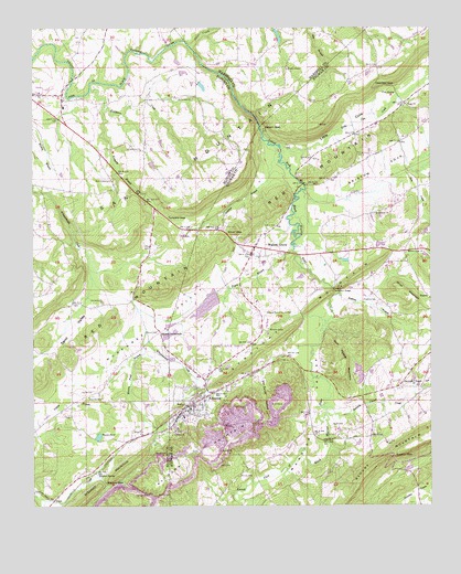
Altoona, AL USGS Topographic Map
Click on map above to begin viewing in our Map Viewer.

This topographic map contains these locations and features:
Feature Name Type Latitude Longitude GNIS ID View Map
AltoonaPopulated PlaceN34.0262°W86.3261°113054View Map
Altoona CemeteryCemeteryN34.0145°W86.3236°140436View Map
Altoona Coal MinesMineN34.0126°W86.3358°135068View Map
Altoona DivisionCivilN34.0558°W86.2620°165768View Map
Altoona Fire and Rescue StationBuildingN34.0329°W86.3117°2683436View Map
Altoona MountainRidgeN34.0129°W86.3186°113055View Map
Altoona Police DepartmentBuildingN34.0262°W86.3265°2752052View Map
Altoona Post OfficePost OfficeN34.0279°W86.3246°2789043View Map
Altoona-Walnut Grove CemeteryCemeteryN34.0504°W86.3030°113056View Map
Bethlehem Methodist ChurchChurchN34.0762°W86.2675°114141View Map
Bird CemeteryCemeteryN34.0701°W86.3291°114364View Map
BoxtelPopulated PlaceN34.0187°W86.2680°140468View Map
Brazill Mill (historical)LocaleN34.1179°W86.3039°139350View Map
Bristow CoveValleyN34.0798°W86.2844°114926View Map
Bristow CreekStreamN34.0823°W86.2900°114927View Map
ClaybornPopulated PlaceN34.1057°W86.2583°149041View Map
Clear CreekStreamN34.1201°W86.3258°116232View Map
Cornelius CemeteryCemeteryN34.0659°W86.2983°149045View Map
Cove Methodist ChurchChurchN34.1051°W86.2578°116742View Map
Cove SpringSpringN34.1079°W86.2608°116744View Map
Crooked GapGapN34.1120°W86.2664°116888View Map
Doctor Jenkins LakeReservoirN34.0524°W86.3201°131922View Map
Drury Bynum GapGapN34.0195°W86.3361°163170View Map
Dry CreekStreamN34.0876°W86.2578°117582View Map
Ellison CemeteryCemeteryN34.0456°W86.3358°117951View Map
Ellison CrossroadsPopulated PlaceN34.0454°W86.3353°156309View Map
Elrod MountainSummitN34.0551°W86.2580°117966View Map
Fowlers Mill (historical)LocaleN34.0995°W86.3241°139384View Map
Graveman Dairy FarmLocaleN34.0839°W86.3300°2704568View Map
Hanna PondLakeN34.0182°W86.3545°119683View Map
Harmony ChurchChurchN34.0534°W86.3533°119755View Map
Harris CemeteryCemeteryN34.0295°W86.3600°119796View Map
HopperPopulated PlaceN34.0554°W86.2514°120392View Map
Jenkins Number One DamDamN34.0334°W86.2716°131904View Map
Jenkins Number One LakeReservoirN34.0335°W86.2720°131905View Map
Jenkins Number Three DamDamN34.0534°W86.3200°131923View Map
Jenkins Number Two DamDamN34.0351°W86.2716°131911View Map
Jenkins Number Two LakeReservoirN34.0351°W86.2716°131910View Map
Kenchelow CreekStreamN34.1093°W86.3569°121134View Map
Kneeves Poultry FarmLocaleN34.1133°W86.3219°2709205View Map
Little CoveValleyN34.0926°W86.2936°121744View Map
Little Cove CreekStreamN34.0932°W86.2972°121746View Map
Maynor GapGapN34.0062°W86.3528°122425View Map
Maynor SpringSpringN34.0082°W86.3550°122426View Map
Mining Pond BranchStreamN34.0465°W86.3397°122868View Map
Moody CemeteryCemeteryN34.0076°W86.3103°164079View Map
Mount Carmel ChurchChurchN34.1070°W86.3253°123179View Map
Nelson GapGapN34.0993°W86.3039°123696View Map
New Emmaus ChurchChurchN34.0851°W86.3497°123745View Map
New HomePopulated PlaceN34.0529°W86.3630°135137View Map
Nix GapGapN34.0534°W86.3439°135138View Map
Old SneadPopulated PlaceN34.1070°W86.3653°149362View Map
PanaPopulated PlaceN34.0390°W86.2950°140675View Map
Parker MineMineN34.0084°W86.2875°140676View Map
Payne BranchStreamN34.0668°W86.2930°124509View Map
Phillips (historical)Populated PlaceN34.0723°W86.3147°149101View Map
Phillips BranchStreamN34.0943°W86.3011°124679View Map
Pine GrovePopulated PlaceN34.0954°W86.2597°149104View Map
Pine Grove ChurchChurchN34.0284°W86.3575°124801View Map
RedbudPopulated PlaceN34.0668°W86.2583°140689View Map
Robbins BranchStreamN34.0554°W86.2789°125688View Map
Robbins CemeteryCemeteryN34.0534°W86.2669°125689View Map
Ruell Snead Dam Number OneDamN34.1134°W86.3283°131940View Map
Ruell Snead Dam Number TwoDamN34.1101°W86.3233°131937View Map
Sam Hopper MountainSummitN34.0390°W86.2786°126280View Map
Samuels ChapelLocaleN34.0315°W86.2522°153312View Map
Samuels Chapel CreekStreamN34.0254°W86.2828°153313View Map
Samuels Chapel United Methodist ChurchChurchN34.0315°W86.2522°149270View Map
Sauls CemeteryCemeteryN34.0206°W86.2808°126428View Map
Schuler (historical)Populated PlaceN34.0187°W86.2869°149115View Map
Silver GapGapN34.0712°W86.3141°126852View Map
Snead ChapelChurchN34.1143°W86.2953°127069View Map
Snead Junior High SchoolSchoolN34.1043°W86.3650°149363View Map
Snead Lake OneReservoirN34.1133°W86.3275°131939View Map
Snead Lake TwoReservoirN34.1098°W86.3217°131936View Map
Sneadview ChurchChurchN34.0932°W86.3411°127071View Map
Straight MountainRidgeN34.0120°W86.3425°127450View Map
Tanyard BranchStreamN34.1040°W86.3525°127678View Map
Tanyard GapGapN34.0754°W86.3330°127688View Map
Thompson BridgeBridgeN34.0565°W86.2803°127890View Map
Town of AltoonaCivilN34.0310°W86.3181°2405146View Map
Town of Walnut GroveCivilN34.0641°W86.2864°2406827View Map
Tumlin GapGapN34.0134°W86.2619°128124View Map
Tumlin Gap Station (historical)LocaleN34.0112°W86.2569°149129View Map
Van Zandt HollowValleyN34.0348°W86.3030°128405View Map
Walnut GrovePopulated PlaceN34.0657°W86.3064°158099View Map
Walnut Grove Police DepartmentBuildingN34.0658°W86.3068°2751951View Map
Walnut Grove Post OfficePost OfficeN34.0658°W86.3057°2788984View Map
Walnut Grove Volunteer Fire DepartmentBuildingN34.0657°W86.3067°2682692View Map
Warrior River Missionary Baptist ChurchChurchN34.0662°W86.2578°128601View Map
Warrior ValleyValleyN34.0420°W86.2886°128602View Map
West End Elementary SchoolSchoolN34.0534°W86.3047°140770View Map
West End High SchoolSchoolN34.0637°W86.3025°140771View Map
West Etowah Volunteer Fire DepartmentBuildingN34.0022°W86.3172°2683468View Map

Note: Coordinates in the location and feature list above are referenced to NAD83 datum.


Copyright (C) 2008-2025 Ryan Niemi / Sunset Dynamics ... All Rights Reserved