TopoQuest Logo
Do you find TopoQuest useful?
Help keep TopoQuest running and adding new maps/features by donating!
Bitcoin:  19c7KJd3qBynnjoSw5npx9KScwjBe4ifkT
Litecoin:  LXs6TkuXGGXo1vDsWCkWVdjQX94eUKd6ui
Home View Maps Find Maps Find Places Resources & Links


Howland, Maine Topographic Map

USGS Map Title: Howland, ME
USGS Map MRC: 45068B6
DRG (GeoTIFF) Download: o45068b6.tif


Neighboring USGS Topographic Map Quads:


  Hardy Pond, ME  
45068C7
 

  Seboeis, ME  
45068C6
 

  Lincoln West, ME  
45068C5
 

  Lagrange, ME  
45068B7
 

  Howland, ME  
45068B6
 

  Passadumkeag, ME  
45068B5
 

  South Lagrange, ME  
45068A7
 

  Greenbush, ME  
45068A6
 

  Olamon, ME  
45068A5


Map MRC Location:

N46°
W69°
N46°
W68°
H8 H7 H6 H5 H4 H3 H2 H1
G8 G7 G6 G5 G4 G3 G2 G1
F8 F7 F6 F5 F4 F3 F2 F1
E8 E7 E6 E5 E4 E3 E2 E1
D8 D7 D6 D5 D4 D3 D2 D1
C8 C7 C6 C5 C4 C3 C2 C1
B8 B7 B6 B5 B4 B3 B2 B1
A8 A7 A6 A5 A4 A3 A2 A1
N45°
W69°
N45°
W68°

Howland, ME USGS 1:24K Topographic Map Preview:
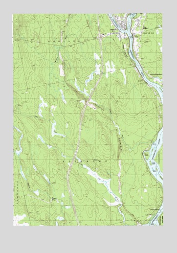
Howland, ME USGS Topographic Map
Click on map above to begin viewing in our Map Viewer.

This topographic map contains these locations and features:
Feature Name Type Latitude Longitude GNIS ID View Map
Buzzport AirportAirportN45.2196°W68.6392°2717197View Map
Church of GodChurchN45.2403°W68.6497°1914006View Map
Craig IslandIslandN45.1656°W68.6406°564447View Map
Edinburg CemeteryCemeteryN45.2031°W68.6318°565792View Map
Emerson RunaroundStreamN45.2217°W68.6523°565897View Map
Fiddler IslandIslandN45.1612°W68.6378°566124View Map
Grass IslandIslandN45.1539°W68.6295°567068View Map
Hichborn Middle SchoolSchoolN45.2476°W68.6620°1913591View Map
HowlandPopulated PlaceN45.2387°W68.6636°568405View Map
Howland Baptist ChurchChurchN45.2453°W68.6564°1913605View Map
Howland DamDamN45.2388°W68.6566°1773793View Map
Howland Fire DepartmentBuildingN45.2428°W68.6585°2552790View Map
Howland Post OfficePost OfficeN45.2422°W68.6570°1913606View Map
Howland United Methodist ChurchChurchN45.2370°W68.6606°1913607View Map
Hoytville HorsebackRidgeN45.1878°W68.6731°568418View Map
Interchange 54CrossingN45.2362°W68.6778°1913628View Map
Nicolar IslandIslandN45.1587°W68.6336°572168View Map
Olamon IslandIslandN45.1264°W68.6292°572677View Map
Penobscot Valley High SchoolSchoolN45.2473°W68.6621°1913817View Map
Piscataquis RiverStreamN45.2392°W68.6586°573447View Map
Piscataquis River ReservoirReservoirN45.2388°W68.6566°1773794View Map
Pollard BrookStreamN45.1739°W68.6359°573576View Map
Saint Leos ChurchChurchN45.2406°W68.6511°1913859View Map
Thomas Free LibraryBuildingN45.2411°W68.6569°2738519View Map
Tomar IslandIslandN45.1684°W68.6373°577182View Map
Town of EdinburgCivilN45.1687°W68.6890°582463View Map
West EnfieldPopulated PlaceN45.2434°W68.6497°578132View Map
West Enfield CemeteryCemeteryN45.2235°W68.6460°578133View Map
West Enfield Post OfficePost OfficeN45.2372°W68.6475°1913973View Map

Note: Coordinates in the location and feature list above are referenced to NAD83 datum.


Copyright (C) 2008-2025 Ryan Niemi / Sunset Dynamics ... All Rights Reserved