TopoQuest Logo
Do you find TopoQuest useful?
Help keep TopoQuest running and adding new maps/features by donating!
Bitcoin:  19c7KJd3qBynnjoSw5npx9KScwjBe4ifkT
Litecoin:  LXs6TkuXGGXo1vDsWCkWVdjQX94eUKd6ui
Home View Maps Find Maps Find Places Resources & Links


Greenbush, Maine Topographic Map

USGS Map Title: Greenbush, ME
USGS Map MRC: 45068A6
DRG (GeoTIFF) Download: o45068a6.tif


Neighboring USGS Topographic Map Quads:


  Lagrange, ME  
45068B7
 

  Howland, ME  
45068B6
 

  Passadumkeag, ME  
45068B5
 

  South Lagrange, ME  
45068A7
 

  Greenbush, ME  
45068A6
 

  Olamon, ME  
45068A5
 

  Pushaw Lake, ME  
44068H7
 

  Old Town, ME  
44068H6
 

  Otter Chain Ponds, ME  
44068H5


Map MRC Location:

N46°
W69°
N46°
W68°
H8 H7 H6 H5 H4 H3 H2 H1
G8 G7 G6 G5 G4 G3 G2 G1
F8 F7 F6 F5 F4 F3 F2 F1
E8 E7 E6 E5 E4 E3 E2 E1
D8 D7 D6 D5 D4 D3 D2 D1
C8 C7 C6 C5 C4 C3 C2 C1
B8 B7 B6 B5 B4 B3 B2 B1
A8 A7 A6 A5 A4 A3 A2 A1
N45°
W69°
N45°
W68°

Greenbush, ME USGS 1:24K Topographic Map Preview:
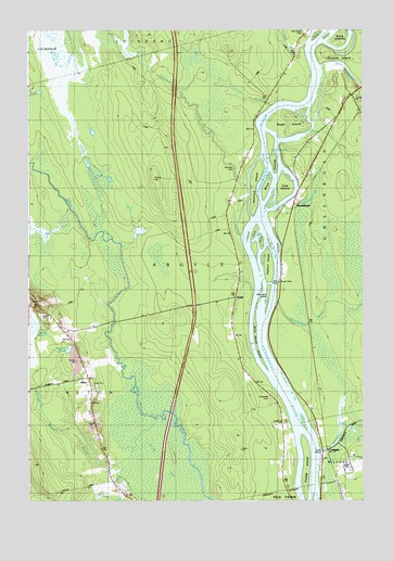
Greenbush, ME USGS Topographic Map
Click on map above to begin viewing in our Map Viewer.

This topographic map contains these locations and features:
Feature Name Type Latitude Longitude GNIS ID View Map
AltonPopulated PlaceN45.0315°W68.7286°578831View Map
Alton BogSwampN45.0120°W68.7042°561217View Map
Alton CemeteryCemeteryN45.0332°W68.7271°561218View Map
Alton ChurchChurchN45.0365°W68.7303°561219View Map
Alton Elementary SchoolSchoolN45.0466°W68.7344°2738077View Map
ArgylePopulated PlaceN45.0542°W68.6723°578830View Map
Birch IslandsIslandN45.0873°W68.6586°562319View Map
Boombridge BrookStreamN45.0528°W68.6578°562749View Map
Bride IslandIslandN45.1231°W68.6442°562950View Map
Brown BrookStreamN45.0215°W68.7028°563035View Map
Cedarvale CemeteryCemeteryN45.0275°W68.6598°563741View Map
CostiganPopulated PlaceN45.0128°W68.6395°564378View Map
Costigan BrookStreamN45.0134°W68.6411°564379View Map
Costigan BrookStreamN45.0231°W68.7442°564380View Map
Cow IslandIslandN45.0831°W68.6548°564414View Map
Ephriam BrookStreamN45.1042°W68.6609°565930View Map
Foster IslandIslandN45.0717°W68.6659°566456View Map
Freese IslandIslandN45.0034°W68.6467°566560View Map
GreenbushPopulated PlaceN45.0803°W68.6509°579363View Map
Greenbush Post OfficePost OfficeN45.0902°W68.6434°2789359View Map
Hazelton BrookStreamN45.0784°W68.6556°567839View Map
Hemlock CemeteryCemeteryN45.0881°W68.6728°567917View Map
Hemlock IslandIslandN45.0845°W68.6664°567920View Map
Hemlock StreamStreamN45.0834°W68.6692°567924View Map
Horse IslandIslandN45.0673°W68.6634°568281View Map
Hoyt BrookStreamN45.1206°W68.6475°568411View Map
Hoyt Brook CemeteryCemeteryN45.1242°W68.6467°578832View Map
Jackson IslandIslandN45.0623°W68.6620°568742View Map
Judkins BrookStreamN45.0098°W68.7153°569015View Map
Mansell PondLakeN45.0404°W68.7348°570710View Map
Socs IslandIslandN45.1226°W68.6350°575705View Map
Stevens BrookStreamN45.1103°W68.6261°576318View Map
Sugar IslandIslandN45.0995°W68.6539°576498View Map
Thorofare IslandIslandN45.0559°W68.6603°577038View Map
Township of ArgyleCivilN45.0806°W68.7053°582328View Map
Unorganized Territory of ArgyleCivilN45.0733°W68.6943°2378257View Map
WBZN-FM (Old Town)TowerN45.0105°W68.7472°582301View Map
White Squaw IslandIslandN45.0448°W68.6659°578375View Map

Note: Coordinates in the location and feature list above are referenced to NAD83 datum.


Copyright (C) 2008-2025 Ryan Niemi / Sunset Dynamics ... All Rights Reserved