TopoQuest Logo
Do you find TopoQuest useful?
Help keep TopoQuest running and adding new maps/features by donating!
Bitcoin:  19c7KJd3qBynnjoSw5npx9KScwjBe4ifkT
Litecoin:  LXs6TkuXGGXo1vDsWCkWVdjQX94eUKd6ui
Home View Maps Find Maps Find Places Resources & Links


Hoytville, Michigan Topographic Map

USGS Map Title: Hoytville, MI
USGS Map MRC: 42084F8
DRG (GeoTIFF) Download: o42084f8.tif


Neighboring USGS Topographic Map Quads:


  Woodbury, MI  
42085G1
 

  Portland South, MI  
42084G8
 

  Eagle, MI  
42084G7
 

  Saubee Lake, MI  
42085F1
 

  Hoytville, MI  
42084F8
 

  Needmore, MI  
42084F7
 

  Nashville, MI  
42085E1
 

  Chester, MI  
42084E8
 

  Charlotte, MI  
42084E7


Map MRC Location:

N43°
W85°
N43°
W84°
H8 H7 H6 H5 H4 H3 H2 H1
G8 G7 G6 G5 G4 G3 G2 G1
F8 F7 F6 F5 F4 F3 F2 F1
E8 E7 E6 E5 E4 E3 E2 E1
D8 D7 D6 D5 D4 D3 D2 D1
C8 C7 C6 C5 C4 C3 C2 C1
B8 B7 B6 B5 B4 B3 B2 B1
A8 A7 A6 A5 A4 A3 A2 A1
N42°
W85°
N42°
W84°

Hoytville, MI USGS 1:24K Topographic Map Preview:
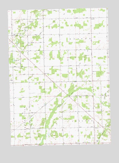
Hoytville, MI USGS Topographic Map
Click on map above to begin viewing in our Map Viewer.

This topographic map contains these locations and features:
Feature Name Type Latitude Longitude GNIS ID View Map
Allen's Post Office (historical)Post OfficeN42.6261°W84.8950°2574839View Map
Ames CemeteryCemeteryN42.6411°W84.9742°620058View Map
Ames SchoolSchoolN42.6414°W84.9342°620063View Map
Brethren ChurchChurchN42.7264°W84.9950°621928View Map
Brick SchoolSchoolN42.6556°W84.9767°621956View Map
Brown SchoolSchoolN42.6409°W84.9944°622095View Map
Chester Gospel ChurchChurchN42.6267°W84.9103°2109953View Map
Dorman SchoolSchoolN42.6256°W84.9300°624795View Map
Dow SchoolSchoolN42.7231°W84.9564°624842View Map
Freemire CemeteryCemeteryN42.6853°W84.9961°626504View Map
GreshamPopulated PlaceN42.6414°W84.8953°627414View Map
Gresham CemeteryCemeteryN42.6278°W84.8939°627415View Map
Gresham Post Office (historical)Post OfficeN42.6414°W84.8953°2575081View Map
Gresham United Methodist ChurchChurchN42.6411°W84.8958°2575026View Map
Gresham United Methodist Church Historical MarkerParkN42.6419°W84.8955°2569691View Map
Hallenbeck SchoolSchoolN42.6267°W84.9858°627654View Map
HoytvillePopulated PlaceN42.7411°W84.8961°628733View Map
Hoytville Post Office (historical)Post OfficeN42.7411°W84.8961°2575080View Map
Kelly Post Office (historical)Post OfficeN42.6833°W84.9464°2575078View Map
Kelly SchoolSchoolN42.6834°W84.9469°629556View Map
Lake SchoolSchoolN42.6698°W84.9964°629994View Map
Law FieldAirportN42.6370°W84.9986°1624190View Map
Little VenicePopulated PlaceN42.6906°W84.9558°1617684View Map
Loucks SchoolSchoolN42.7050°W84.9258°631121View Map
Moyer CemeteryCemeteryN42.6925°W84.8958°632856View Map
Moyer SchoolSchoolN42.6845°W84.8955°632858View Map
Roxana Post Office (historical)Post OfficeN42.6833°W84.8958°2575072View Map
Roxand Center SchoolSchoolN42.7245°W84.8969°636349View Map
ShaytownPopulated PlaceN42.7042°W84.9761°1617849View Map
Shaytown Post Office (historical)Post OfficeN42.7042°W84.9756°2575077View Map
Shaytown SchoolSchoolN42.6973°W84.9764°637700View Map
Sinclair LakeLakeN42.7036°W84.9941°637996View Map
Smith SchoolSchoolN42.6561°W84.9050°638175View Map
Stalls CornerPopulated PlaceN42.6411°W84.8950°1617863View Map
Sunfield CemeteryCemeteryN42.7278°W84.9908°639075View Map
Thompson CreekStreamN42.6331°W84.9575°1614763View Map
Township of ChesterCivilN42.6401°W84.8963°1626071View Map
Township of RoxandCivilN42.7268°W84.8965°1627010View Map
Welch CemeteryCemeteryN42.7175°W84.9767°1615980View Map
Who-Wit-Tah ChurchChurchN42.7281°W84.9847°2109955View Map
Winchell and Union DrainCanalN42.7367°W84.9456°2109956View Map

Note: Coordinates in the location and feature list above are referenced to NAD83 datum.


Copyright (C) 2008-2025 Ryan Niemi / Sunset Dynamics ... All Rights Reserved