TopoQuest Logo
Do you find TopoQuest useful?
Help keep TopoQuest running and adding new maps/features by donating!
Bitcoin:  19c7KJd3qBynnjoSw5npx9KScwjBe4ifkT
Litecoin:  LXs6TkuXGGXo1vDsWCkWVdjQX94eUKd6ui
Home View Maps Find Maps Find Places Resources & Links


Nashville, Michigan Topographic Map

USGS Map Title: Nashville, MI
USGS Map MRC: 42085E1
DRG (GeoTIFF) Download: o42085e1.tif


Neighboring USGS Topographic Map Quads:


  Woodland, MI  
42085F2
 

  Saubee Lake, MI  
42085F1
 

  Hoytville, MI  
42084F8
 

  Maple Grove, MI  
42085E2
 

  Nashville, MI  
42085E1
 

  Chester, MI  
42084E8
 

  Bedford, MI  
42085D2
 

  Bellevue, MI  
42085D1
 

  Olivet, MI  
42084D8


Map MRC Location:

N43°
W86°
N43°
W85°
H8 H7 H6 H5 H4 H3 H2 H1
G8 G7 G6 G5 G4 G3 G2 G1
F8 F7 F6 F5 F4 F3 F2 F1
E8 E7 E6 E5 E4 E3 E2 E1
D8 D7 D6 D5 D4 D3 D2 D1
C8 C7 C6 C5 C4 C3 C2 C1
B8 B7 B6 B5 B4 B3 B2 B1
A8 A7 A6 A5 A4 A3 A2 A1
N42°
W86°
N42°
W85°

Nashville, MI USGS 1:24K Topographic Map Preview:
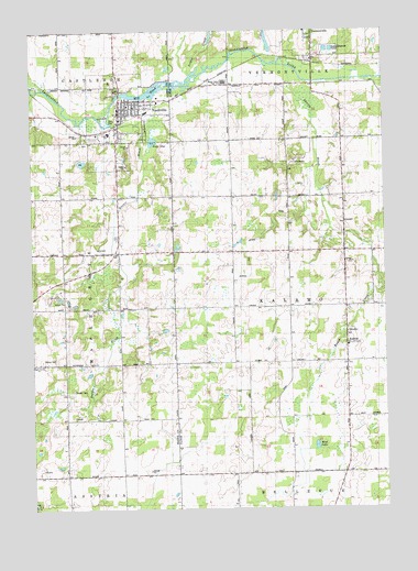
Nashville, MI USGS Topographic Map
Click on map above to begin viewing in our Map Viewer.

This topographic map contains these locations and features:
Feature Name Type Latitude Longitude GNIS ID View Map
Assembly of God ChurchChurchN42.6069°W85.0844°2572749View Map
Barnes SchoolSchoolN42.5967°W85.0547°620625View Map
Beigh SchoolSchoolN42.5820°W85.0933°621017View Map
Castleto - Maple Grove - Nashville Ambulance ServiceBuildingN42.6057°W85.0932°2662126View Map
Castleto - Maple Grove - Nashville Fire DepartmentBuildingN42.6058°W85.0932°2572757View Map
Church of the NazareneChurchN42.5981°W85.1011°2572751View Map
Evans SchoolSchoolN42.5084°W85.0633°625679View Map
First Congregational Church Historical MarkerParkN42.6248°W85.0249°2569710View Map
Grace Community ChurchChurchN42.6033°W85.1181°2572750View Map
Hayon CreekStreamN42.5839°W85.0228°628004View Map
KalamoPopulated PlaceN42.5428°W85.0128°629448View Map
Kalamo CemeteryCemeteryN42.5461°W85.0111°2574877View Map
Kalamo Post Office (historical)Post OfficeN42.5428°W85.0128°2575079View Map
Kalamo United Methodist ChurchChurchN42.5461°W85.0136°2575021View Map
Kellogg Education CenterSchoolN42.6056°W85.0906°2572756View Map
Lake OneLakeN42.5959°W85.0817°634062View Map
Maple Grove ChurchChurchN42.5381°W85.1228°2109218View Map
Maple Valley High SchoolSchoolN42.6117°W85.0561°2109959View Map
Mason CemeteryCemeteryN42.5669°W85.0508°2574878View Map
Mason SchoolSchoolN42.5664°W85.0539°631720View Map
Mayo SchoolSchoolN42.5086°W85.1136°631782View Map
Mill PondLakeN42.6098°W85.0806°632336View Map
Mud LakeLakeN42.5164°W85.0249°632928View Map
NashvillePopulated PlaceN42.6028°W85.0931°633223View Map
Nashville Baptist ChurchChurchN42.6053°W85.0883°2572746View Map
Nashville CemeteryCemeteryN42.5986°W85.0844°2572233View Map
Nashville Family MedicineHospitalN42.5958°W85.0944°2572755View Map
Nashville Police DepartmentBuildingN42.6042°W85.0933°2572753View Map
Nashville Post OfficePost OfficeN42.6050°W85.0936°2572754View Map
Nashville Station (historical)LocaleN42.6011°W85.0925°2572752View Map
Nashville United Methodist ChurchChurchN42.6047°W85.0917°2572747View Map
Putnam Public LibraryBuildingN42.6061°W85.0936°2572758View Map
Putnam Public Library Historical MarkerParkN42.6053°W85.0935°2564496View Map
Quail Trap SchoolSchoolN42.5392°W85.0928°635538View Map
Quaker BrookStreamN42.6000°W85.0989°635539View Map
Quaker CemeteryCemeteryN42.5311°W85.1106°635540View Map
Saint Cyril Catholic ChurchChurchN42.6042°W85.0925°2572748View Map
Scipio CreekStreamN42.6131°W85.0681°637452View Map
Shanty BrookStreamN42.6161°W85.0333°637661View Map
Township of KalamoCivilN42.5530°W85.0147°1626549View Map
Vermontville Station (historical)LocaleN42.6172°W85.0256°2574799View Map
Village of NashvilleCivilN42.6031°W85.0941°2399438View Map
Wilcox CemeteryCemeteryN42.5389°W85.1217°2109217View Map

Note: Coordinates in the location and feature list above are referenced to NAD83 datum.


Copyright (C) 2008-2025 Ryan Niemi / Sunset Dynamics ... All Rights Reserved