TopoQuest Logo
Do you find TopoQuest useful?
Help keep TopoQuest running and adding new maps/features by donating!
Bitcoin:  19c7KJd3qBynnjoSw5npx9KScwjBe4ifkT
Litecoin:  LXs6TkuXGGXo1vDsWCkWVdjQX94eUKd6ui
Home View Maps Find Maps Find Places Resources & Links


Hub City, South Dakota Topographic Map

USGS Map Title: Hub City, SD
USGS Map MRC: 42096H8
DRG (GeoTIFF) Download: o42096h8.tif


Neighboring USGS Topographic Map Quads:


  Wakonda, SD  
43097A1
 

  Centerville, SD  
43096A8
 

  Beresford, SD  
43096A7
 

  Gayville NE, SD  
42097H1
 

  Hub City, SD  
42096H8
 

  Alsen, SD  
42096H7
 

  Meckling, SD  
42097G1
 

  Vermillion, SD  
42096G8
 

  Vermillion SE, SD  
42096G7


Map MRC Location:

N43°
W97°
N43°
W96°
H8 H7 H6 H5 H4 H3 H2 H1
G8 G7 G6 G5 G4 G3 G2 G1
F8 F7 F6 F5 F4 F3 F2 F1
E8 E7 E6 E5 E4 E3 E2 E1
D8 D7 D6 D5 D4 D3 D2 D1
C8 C7 C6 C5 C4 C3 C2 C1
B8 B7 B6 B5 B4 B3 B2 B1
A8 A7 A6 A5 A4 A3 A2 A1
N42°
W97°
N42°
W96°

Hub City, SD USGS 1:24K Topographic Map Preview:
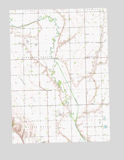
Hub City, SD USGS Topographic Map
Click on map above to begin viewing in our Map Viewer.

This topographic map contains these locations and features:
Feature Name Type Latitude Longitude GNIS ID View Map
Alson (historical)LocaleN42.9722°W96.9253°1267175View Map
Baptist CreekStreamN42.9100°W96.9156°1265116View Map
BloomingdalePopulated PlaceN42.9244°W96.9567°1261098View Map
Bloomingdale Methodist Church (historical)ChurchN42.8889°W96.9392°1264495View Map
Cabbage FlatFlatN42.9339°W96.9839°1265141View Map
Clay CountyCivilN42.9146°W96.9756°1265764View Map
Clay County Waterfowl Production AreaParkN42.8971°W96.8823°2765244View Map
Clay PointPopulated PlaceN42.9097°W96.9031°1264500View Map
Clay Point CemeteryCemeteryN42.8987°W96.9066°1254386View Map
DalesburgPopulated PlaceN42.9769°W96.9042°1265173View Map
Dalesburg Baptist CemeteryCemeteryN42.9673°W96.8852°2773622View Map
Dalesburg ChurchChurchN42.9678°W96.8850°1265174View Map
Dalesburg SchoolSchoolN42.9686°W96.9039°1265175View Map
Garfield TabernacleChurchN42.9103°W96.8989°1265228View Map
Hub CityPopulated PlaceN42.9536°W96.9045°1255697View Map
Lake Como (historical)LakeN42.8931°W96.8823°1264483View Map
Lake Emeline (historical)LakeN42.8931°W96.9170°1264482View Map
LodiPopulated PlaceN42.9825°W96.9839°1261035View Map
Lodi AirportAirportN42.9732°W96.9833°2444008View Map
Marshalltown (historical)Populated PlaceN42.9403°W96.9045°1264501View Map
Marshalltown School (historical)SchoolN42.9278°W96.8878°1264478View Map
Old Lodi CemeteryCemeteryN42.9758°W96.9911°1256190View Map
Pleasant Dell School (historical)SchoolN42.9458°W96.9962°1264475View Map
Spirit Mound CemeteryCemeteryN42.8886°W96.9428°1258238View Map
Township of Pleasant ValleyCivilN42.9532°W96.9831°1268213View Map

Note: Coordinates in the location and feature list above are referenced to NAD83 datum.


Copyright (C) 2008-2024 Ryan Niemi / Sunset Dynamics ... All Rights Reserved