TopoQuest Logo
Do you find TopoQuest useful?
Help keep TopoQuest running and adding new maps/features by donating!
Bitcoin:  19c7KJd3qBynnjoSw5npx9KScwjBe4ifkT
Litecoin:  LXs6TkuXGGXo1vDsWCkWVdjQX94eUKd6ui
Home View Maps Find Maps Find Places Resources & Links


Huggins, Missouri Topographic Map

USGS Map Title: Huggins, MO
USGS Map MRC: 37092C2
DRG (GeoTIFF) Download: o37092c2.tif


Neighboring USGS Topographic Map Quads:


  Manes, MO  
37092D3
 

  Roubidoux, MO  
37092D2
 

  Success, MO  
37092D1
 

  Dawson, MO  
37092C3
 

  Huggins, MO  
37092C2
 

  Bucyrus, MO  
37092C1
 

  Mountain Grove North, MO  
37092B3
 

  Cabool NW, MO  
37092B2
 

  Cabool NE, MO  
37092B1


Map MRC Location:

N38°
W93°
N38°
W92°
H8 H7 H6 H5 H4 H3 H2 H1
G8 G7 G6 G5 G4 G3 G2 G1
F8 F7 F6 F5 F4 F3 F2 F1
E8 E7 E6 E5 E4 E3 E2 E1
D8 D7 D6 D5 D4 D3 D2 D1
C8 C7 C6 C5 C4 C3 C2 C1
B8 B7 B6 B5 B4 B3 B2 B1
A8 A7 A6 A5 A4 A3 A2 A1
N37°
W93°
N37°
W92°

Huggins, MO USGS 1:24K Topographic Map Preview:
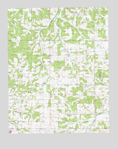
Huggins, MO USGS Topographic Map
Click on map above to begin viewing in our Map Viewer.

This topographic map contains these locations and features:
Feature Name Type Latitude Longitude GNIS ID View Map
AlicePopulated PlaceN37.2984°W92.1888°735326View Map
Alice SchoolSchoolN37.2987°W92.1871°713206View Map
Ballard ChurchChurchN37.3720°W92.2218°735327View Map
Ballard SchoolSchoolN37.3714°W92.2210°713607View Map
BendavisPopulated PlaceN37.2984°W92.2074°740669View Map
Cedar Valley ChurchChurchN37.3270°W92.1993°755582View Map
Cedar Valley SchoolSchoolN37.3270°W92.1985°715619View Map
Dunsmore SchoolSchoolN37.2767°W92.2254°717201View Map
FairviewPopulated PlaceN37.2984°W92.1638°738445View Map
Fairview ChurchChurchN37.2987°W92.1627°717775View Map
Flying 'E' AirportAirportN37.3519°W92.1272°2679343View Map
Hickory Ridge ChurchChurchN37.3664°W92.1574°719492View Map
HugginsPopulated PlaceN37.3200°W92.1985°740948View Map
Huggins Post OfficePost OfficeN37.3202°W92.1975°2783155View Map
Huggins Volunteer Fire Department Station 1BuildingN37.3724°W92.2221°2621412View Map
Logan School (historical)SchoolN37.3206°W92.2243°721425View Map
Lone Star School (historical)SchoolN37.2537°W92.1252°721482View Map
Murr SchoolSchoolN37.2692°W92.1665°723079View Map
Oak Grove SchoolSchoolN37.3284°W92.1721°723594View Map
Pairlee Freeman Barnes State Wildlife AreaParkN37.3073°W92.1360°743007View Map
Pleasant RidgePopulated PlaceN37.3637°W92.1699°735328View Map
Pleasant Ridge SchoolSchoolN37.3625°W92.1710°724591View Map
Racket Ridge SchoolSchoolN37.2909°W92.1346°725048View Map
Rock Springs ChurchChurchN37.2756°W92.2085°730196View Map
Sycamore CreekStreamN37.2742°W92.2499°727408View Map
Township of MorrisCivilN37.2743°W92.1648°767470View Map
Tuttle CemeteryCemeteryN37.3670°W92.1990°727919View Map
UptonPopulated PlaceN37.3689°W92.1640°728081View Map
White CemeteryCemeteryN37.3214°W92.2110°728718View Map

Note: Coordinates in the location and feature list above are referenced to NAD83 datum.


Copyright (C) 2008-2025 Ryan Niemi / Sunset Dynamics ... All Rights Reserved