TopoQuest Logo
Do you find TopoQuest useful?
Help keep TopoQuest running and adding new maps/features by donating!
Bitcoin:  19c7KJd3qBynnjoSw5npx9KScwjBe4ifkT
Litecoin:  LXs6TkuXGGXo1vDsWCkWVdjQX94eUKd6ui
Home View Maps Find Maps Find Places Resources & Links


Mountain Grove North, Missouri Topographic Map

USGS Map Title: Mountain Grove North, MO
USGS Map MRC: 37092B3
DRG (GeoTIFF) Download: o37092b3.tif


Neighboring USGS Topographic Map Quads:


  Fuson, MO  
37092C4
 

  Dawson, MO  
37092C3
 

  Huggins, MO  
37092C2
 

  Owens, MO  
37092B4
 

  Mountain Grove North, MO  
37092B3
 

  Cabool NW, MO  
37092B2
 

  Norwood, MO  
37092A4
 

  Mountain Grove South, MO  
37092A3
 

  Cabool SW, MO  
37092A2


Map MRC Location:

N38°
W93°
N38°
W92°
H8 H7 H6 H5 H4 H3 H2 H1
G8 G7 G6 G5 G4 G3 G2 G1
F8 F7 F6 F5 F4 F3 F2 F1
E8 E7 E6 E5 E4 E3 E2 E1
D8 D7 D6 D5 D4 D3 D2 D1
C8 C7 C6 C5 C4 C3 C2 C1
B8 B7 B6 B5 B4 B3 B2 B1
A8 A7 A6 A5 A4 A3 A2 A1
N37°
W93°
N37°
W92°

Mountain Grove North, MO USGS 1:24K Topographic Map Preview:
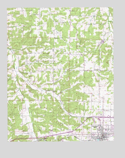
Mountain Grove North, MO USGS Topographic Map
Click on map above to begin viewing in our Map Viewer.

This topographic map contains these locations and features:
Feature Name Type Latitude Longitude GNIS ID View Map
Absher CemeteryCemeteryN37.1684°W92.3629°713129View Map
Absher ProngStreamN37.1745°W92.3613°737878View Map
Antler (historical)Populated PlaceN37.2167°W92.2935°740483View Map
Antler Post OfficePost OfficeN37.2167°W92.2935°760008View Map
Casebeer LakeReservoirN37.2144°W92.2681°763845View Map
Casebeer Lake DamDamN37.2151°W92.2685°763844View Map
City of Mountain GroveCivilN37.1341°W92.2660°2395132View Map
Cross Roads School (historical)SchoolN37.1339°W92.3693°735065View Map
Dake CreekStreamN37.1664°W92.3191°716639View Map
Davis SpringSpringN37.1470°W92.2777°716741View Map
Doril Leascher LakeReservoirN37.1809°W92.3436°763841View Map
Dove MountainsRangeN37.2184°W92.2877°717019View Map
East Whetstone CreekStreamN37.1889°W92.3643°717352View Map
Fairview ChurchChurchN37.1720°W92.3213°717773View Map
Fairview SchoolSchoolN37.1726°W92.3257°717801View Map
Friendship Baptist ChurchChurchN37.2467°W92.3002°718236View Map
Friendship CemeteryCemeteryN37.2467°W92.3002°1852281View Map
Hawley (historical)Populated PlaceN37.1689°W92.3485°740482View Map
Hawley Post OfficePost OfficeN37.1689°W92.3485°760014View Map
Helum CemeteryCemeteryN37.1562°W92.3574°719361View Map
Hilcrest Shopping CenterLocaleN37.1464°W92.2602°742507View Map
Hillcrest CemeteryCemeteryN37.1498°W92.2654°719609View Map
Leascher Lake DamDamN37.1801°W92.3452°763840View Map
Leonard HollowValleyN37.1853°W92.3671°720912View Map
Lily LakeReservoirN37.1263°W92.2688°721060View Map
Morning Sun ChurchChurchN37.2214°W92.3196°722628View Map
Morning Sun SchoolSchoolN37.2439°W92.3379°722629View Map
Mountain GrovePopulated PlaceN37.1306°W92.2635°751209View Map
Mountain Grove Police DepartmentBuildingN37.1306°W92.2625°2752224View Map
Mountain Grove Post OfficePost OfficeN37.1286°W92.2631°2782837View Map
Mountain Grove Volunteer Fire Department North StationBuildingN37.1443°W92.2643°2621642View Map
Mountain Valley CemeteryCemeteryN37.1912°W92.3385°722994View Map
Mountain Valley ChurchChurchN37.1892°W92.3513°722995View Map
Mountain Valley SchoolSchoolN37.2076°W92.3332°722996View Map
North Campbell SchoolSchoolN37.2345°W92.2749°723435View Map
Number 284 Dam (historical)DamN37.1434°W92.2618°764318View Map
Oak Ridge AirparkAirportN37.1637°W92.3251°2679372View Map
Plemmons BranchStreamN37.1742°W92.3371°724656View Map
Porter LakeReservoirN37.2173°W92.2615°763843View Map
Porter Lake DamDamN37.2184°W92.2618°763842View Map
Sanders CreekStreamN37.1473°W92.2916°726030View Map
Stony Point ChurchChurchN37.1264°W92.3199°727151View Map
Swede CemeteryCemeteryN37.1361°W92.2679°727370View Map
Township of WoodCivilN37.2023°W92.3284°767556View Map
West Campbell SchoolSchoolN37.1278°W92.3352°728540View Map
Whetstone (historical)LocaleN37.1281°W92.3054°740484View Map
Whetstone ChurchChurchN37.1351°W92.3521°728696View Map
Williams BranchStreamN37.2376°W92.2557°728880View Map
Willow Springs CemeteryCemeteryN37.1909°W92.2849°728947View Map
Willow Springs SchoolSchoolN37.1912°W92.2732°728950View Map

Note: Coordinates in the location and feature list above are referenced to NAD83 datum.


Copyright (C) 2008-2025 Ryan Niemi / Sunset Dynamics ... All Rights Reserved