TopoQuest Logo
Do you find TopoQuest useful?
Help keep TopoQuest running and adding new maps/features by donating!
Bitcoin:  19c7KJd3qBynnjoSw5npx9KScwjBe4ifkT
Litecoin:  LXs6TkuXGGXo1vDsWCkWVdjQX94eUKd6ui
Home View Maps Find Maps Find Places Resources & Links


Hughes, Louisiana Topographic Map

USGS Map Title: Hughes, LA
USGS Map MRC: 32093G6
DRG (GeoTIFF) Download: o32093g6.tif


Neighboring USGS Topographic Map Quads:


  Wardview, LA  
32093H7
 

  Plain Dealing, LA  
32093H6
 

  Carterville, LA  
32093H5
 

  Gilliam, LA  
32093G7
 

  Hughes, LA  
32093G6
 

  Ivan, LA  
32093G5
 

  Dixie, LA  
32093F7
 

  Benton, LA  
32093F6
 

  Bodcau Lake, LA  
32093F5


Map MRC Location:

N33°
W94°
N33°
W93°
H8 H7 H6 H5 H4 H3 H2 H1
G8 G7 G6 G5 G4 G3 G2 G1
F8 F7 F6 F5 F4 F3 F2 F1
E8 E7 E6 E5 E4 E3 E2 E1
D8 D7 D6 D5 D4 D3 D2 D1
C8 C7 C6 C5 C4 C3 C2 C1
B8 B7 B6 B5 B4 B3 B2 B1
A8 A7 A6 A5 A4 A3 A2 A1
N32°
W94°
N32°
W93°

Hughes, LA USGS 1:24K Topographic Map Preview:
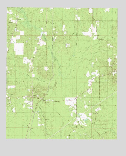
Hughes, LA USGS Topographic Map
Click on map above to begin viewing in our Map Viewer.

This topographic map contains these locations and features:
Feature Name Type Latitude Longitude GNIS ID View Map
Alden BridgePopulated PlaceN32.7751°W93.7202°532100View Map
Benton Fire District 4 Station 5BuildingN32.7897°W93.7172°2673054View Map
Benton Fire District 4 Station 6BuildingN32.7743°W93.6488°2673066View Map
Bookers ChapelChurchN32.7896°W93.7266°540839View Map
Bounds BranchStreamN32.8293°W93.6649°533347View Map
Brushy BranchStreamN32.7982°W93.7018°533466View Map
CollinsburgPopulated PlaceN32.8629°W93.7377°554051View Map
Collinsburg CemeteryCemeteryN32.8604°W93.7438°534048View Map
Collinsburg CreekStreamN32.8099°W93.6918°554052View Map
Collinsburg Oil FieldOilfieldN32.8446°W93.7455°550804View Map
Cottage Grove CemeteryCemeteryN32.7887°W93.7466°550806View Map
Cottage Grove ChurchChurchN32.7888°W93.7471°534156View Map
Crossway SloughStreamN32.7588°W93.6324°554142View Map
Dove Dale CemeteryCemeteryN32.7687°W93.7068°534577View Map
Flat BranchStreamN32.8449°W93.6427°534984View Map
High CemeteryCemeteryN32.8443°W93.7449°535664View Map
HughesPopulated PlaceN32.7879°W93.7099°554798View Map
Lewisville ChurchChurchN32.8501°W93.7432°540845View Map
Little Cypress BayouStreamN32.8160°W93.6799°536540View Map
Louisville SchoolSchoolN32.8518°W93.7427°536754View Map
New Bethel ChurchChurchN32.7851°W93.7221°540847View Map
New Bethel Number 1 ChurchChurchN32.7688°W93.7141°540849View Map
New Hope ChurchChurchN32.8488°W93.7432°540850View Map
New Light ChurchChurchN32.7746°W93.6493°537603View Map
Parish Governing Authority District 4CivilN32.8300°W93.6257°1930000View Map
Rocky MountPopulated PlaceN32.8146°W93.6293°555822View Map
Sunflower ChurchChurchN32.8354°W93.7157°539726View Map
SwindlevillePopulated PlaceN32.7893°W93.7207°539772View Map

Note: Coordinates in the location and feature list above are referenced to NAD83 datum.


Copyright (C) 2008-2024 Ryan Niemi / Sunset Dynamics ... All Rights Reserved