TopoQuest Logo
Do you find TopoQuest useful?
Help keep TopoQuest running and adding new maps/features by donating!
Bitcoin:  19c7KJd3qBynnjoSw5npx9KScwjBe4ifkT
Litecoin:  LXs6TkuXGGXo1vDsWCkWVdjQX94eUKd6ui
Home View Maps Find Maps Find Places Resources & Links


Bodcau Lake, Louisiana Topographic Map

USGS Map Title: Bodcau Lake, LA
USGS Map MRC: 32093F5
DRG (GeoTIFF) Download: o32093f5.tif


Neighboring USGS Topographic Map Quads:


  Hughes, LA  
32093G6
 

  Ivan, LA  
32093G5
 

  Cotton Valley, LA  
32093G4
 

  Benton, LA  
32093F6
 

  Bodcau Lake, LA  
32093F5
 

  Hortman, LA  
32093F4
 

  Bossier City, LA  
32093E6
 

  Eastwood, LA  
32093E5
 

  Doyline, LA  
32093E4


Map MRC Location:

N33°
W94°
N33°
W93°
H8 H7 H6 H5 H4 H3 H2 H1
G8 G7 G6 G5 G4 G3 G2 G1
F8 F7 F6 F5 F4 F3 F2 F1
E8 E7 E6 E5 E4 E3 E2 E1
D8 D7 D6 D5 D4 D3 D2 D1
C8 C7 C6 C5 C4 C3 C2 C1
B8 B7 B6 B5 B4 B3 B2 B1
A8 A7 A6 A5 A4 A3 A2 A1
N32°
W94°
N32°
W93°

Bodcau Lake, LA USGS 1:24K Topographic Map Preview:
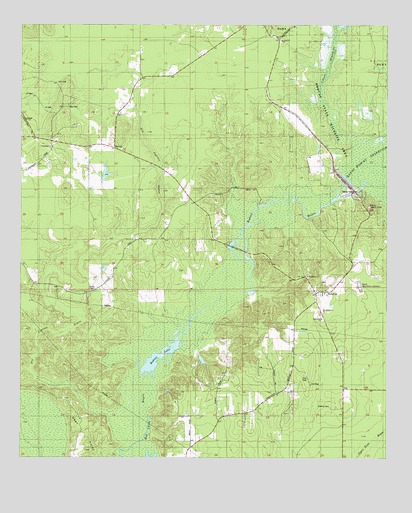
Bodcau Lake, LA USGS Topographic Map
Click on map above to begin viewing in our Map Viewer.

This topographic map contains these locations and features:
Feature Name Type Latitude Longitude GNIS ID View Map
Bayou Bodcau DamDamN32.7046°W93.5135°553419View Map
Belcher ChapelChurchN32.6732°W93.6010°532902View Map
Belle-Park ChurchChurchN32.6654°W93.5224°532929View Map
BellevuePopulated PlaceN32.6732°W93.5221°553590View Map
Benton Fire District 4 Station 4BuildingN32.7084°W93.5761°2673055View Map
Bethlehem ChurchChurchN32.6776°W93.5271°532995View Map
Bodcau BayouStreamN32.6585°W93.5716°553733View Map
Bodcau CreekStreamN32.6674°W93.5649°76387View Map
Bodcau LakeLakeN32.6553°W93.5767°553734View Map
Bodcau Lookout TowerTowerN32.6974°W93.5066°558748View Map
Bossier ParishCivilN32.6789°W93.6050°558453View Map
Bossier Parish Fire District 1 Station 4BuildingN32.6713°W93.5245°2673077View Map
Bundytown (historical)LocaleN32.7147°W93.6022°2564022View Map
Dry Cypress BayouStreamN32.6493°W93.6205°534617View Map
Friendship ChurchChurchN32.7149°W93.6146°535123View Map
Hawkins CemeteryCemeteryN32.6401°W93.5193°535566View Map
Longview ChurchChurchN32.7457°W93.5363°536720View Map
Longview School (historical)SchoolN32.7451°W93.5366°540785View Map
MidwayPopulated PlaceN32.7146°W93.5935°541144View Map
Mount Canaan ChurchChurchN32.6674°W93.5216°537301View Map
Tidwell BranchStreamN32.7276°W93.5216°539919View Map

Note: Coordinates in the location and feature list above are referenced to NAD83 datum.


Copyright (C) 2008-2025 Ryan Niemi / Sunset Dynamics ... All Rights Reserved