TopoQuest Logo
Do you find TopoQuest useful?
Help keep TopoQuest running and adding new maps/features by donating!
Bitcoin:  19c7KJd3qBynnjoSw5npx9KScwjBe4ifkT
Litecoin:  LXs6TkuXGGXo1vDsWCkWVdjQX94eUKd6ui
Home View Maps Find Maps Find Places Resources & Links


Hume, California Topographic Map

USGS Map Title: Hume, CA
USGS Map MRC: 36118G8
DRG (GeoTIFF) Download: o36118g8.tif


Neighboring USGS Topographic Map Quads:


  Patterson Mountain, CA  
36119H1
 

  Rough Spur, CA  
36118H8
 

  Tehipite Dome, CA  
36118H7
 

  Verplank Ridge, CA  
36119G1
 

  Hume, CA  
36118G8
 

  Wren Peak, CA  
36118G7
 

  Miramonte, CA  
36119F1
 

  General Grant Grove, CA  
36118F8
 

  Muir Grove, CA  
36118F7


Map MRC Location:

N37°
W119°
N37°
W118°
H8 H7 H6 H5 H4 H3 H2 H1
G8 G7 G6 G5 G4 G3 G2 G1
F8 F7 F6 F5 F4 F3 F2 F1
E8 E7 E6 E5 E4 E3 E2 E1
D8 D7 D6 D5 D4 D3 D2 D1
C8 C7 C6 C5 C4 C3 C2 C1
B8 B7 B6 B5 B4 B3 B2 B1
A8 A7 A6 A5 A4 A3 A2 A1
N36°
W119°
N36°
W118°

Hume, CA USGS 1:24K Topographic Map Preview:
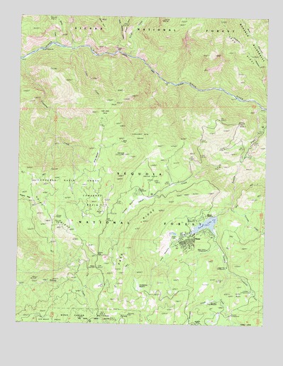
Hume, CA USGS Topographic Map
Click on map above to begin viewing in our Map Viewer.

This topographic map contains these locations and features:
Feature Name Type Latitude Longitude GNIS ID View Map
Aspen Hollow CampgroundLocaleN36.7797°W118.9026°275938View Map
Aspen Hollow CampgroundLocaleN36.7805°W118.9051°276395View Map
Bartons ResortLocaleN36.8186°W118.8873°256566View Map
Bearskin CreekStreamN36.7608°W118.8996°256748View Map
Bearskin MeadowFlatN36.7597°W118.9029°256750View Map
Boole TreeLocaleN36.8238°W118.9493°257348View Map
Cabin CreekStreamN36.8613°W118.9734°257797View Map
Cabin Creek GroveWoodsN36.8352°W118.9551°257801View Map
Camp Nineteen StationLocaleN36.8069°W118.9246°276391View Map
Cherry GapGapN36.7777°W118.9604°258247View Map
Chicago StumpLocaleN36.7936°W118.9801°275827View Map
Converse BasinBasinN36.7994°W118.9676°258657View Map
Converse Basin GroveWoodsN36.8058°W118.9784°258658View Map
Converse MountainSummitN36.8190°W118.9472°258660View Map
Converse Mountain GroveWoodsN36.8244°W118.9409°258661View Map
Garlic FallsFallsN36.8613°W118.9521°260484View Map
Garlic Meadow CreekStreamN36.8602°W118.9526°260485View Map
Hoist RidgeRidgeN36.7815°W118.9623°261411View Map
Huckleberry MeadowFlatN36.7641°W118.9401°261590View Map
HumePopulated PlaceN36.7849°W118.9137°1658799View Map
Hume Forest Service FacilityLocaleN36.7944°W118.9054°275939View Map
Hume LakeLakeN36.7908°W118.9055°261620View Map
Hume Lake CampgroundLocaleN36.7924°W118.9093°1667425View Map
Hume Lake Christian CampLocaleN36.7866°W118.9134°1811603View Map
Hume Lake Volunteer Fire and Rescue CompanyBuildingN36.7840°W118.9233°2624011View Map
Hume Post OfficePost OfficeN36.7873°W118.9140°2769544View Map
Hume Post OfficePost OfficeN36.8046°W118.9181°2769360View Map
Hume Post Office (historical)Post OfficeN36.7849°W118.9137°1940063View Map
Hume StationPopulated PlaceN36.7944°W118.9051°1667426View Map
Indian BasinBasinN36.7983°W118.9443°261709View Map
Indian Basin GroveWoodsN36.8083°W118.9348°261710View Map
Indian CreekStreamN36.8163°W118.8893°261716View Map
Junction Vista PointLocaleN36.8152°W118.8901°1667427View Map
Landslide CampgroundLocaleN36.7636°W118.8820°1655034View Map
Landslide CampgroundLocaleN36.7636°W118.8834°1667428View Map
Landslide CreekStreamN36.7711°W118.8946°266896View Map
Lava ButteSummitN36.7601°W118.8894°262359View Map
Legger Flat CampgroundLocaleN36.7713°W118.8957°275937View Map
Logger Flat CampgroundLocaleN36.7736°W118.8948°276394View Map
Long MeadowFlatN36.7808°W118.9257°262858View Map
McGee Vista PointLocaleN36.7727°W118.9612°1667429View Map
Middle Fork Kings RiverStreamN36.8383°W118.8751°234289View Map
Panoramic PointLocaleN36.7538°W118.9446°1667432View Map
Powder Can Picnic AreaLocaleN36.7894°W118.9129°276396View Map
Powder Canyon Picnic AreaLocaleN36.7891°W118.9107°1811607View Map
Princess CampgroundLocaleN36.8038°W118.9434°275940View Map
Rough CreekStreamN36.8586°W118.9459°265592View Map
Sandy Cove BeachBeachN36.7880°W118.9015°1811609View Map
Sandy Cove Beach Picnic AreaLocaleN36.7877°W118.9012°1811610View Map
South Fork Kings RiverStreamN36.8383°W118.8751°235020View Map
Spring CreekStreamN36.8633°W118.9843°267592View Map
Stump MeadowFlatN36.8174°W118.9648°1667435View Map
Ten Mile CampgroundLocaleN36.7547°W118.8951°275936View Map
Tenmile CreekStreamN36.8397°W118.8807°268143View Map
Tornado CreekStreamN36.7994°W118.8934°268359View Map
Verplank RidgeRidgeN36.8012°W118.9946°237058View Map
Yucca PointSummitN36.8292°W118.8977°276392View Map

Note: Coordinates in the location and feature list above are referenced to NAD83 datum.


Copyright (C) 2008-2024 Ryan Niemi / Sunset Dynamics ... All Rights Reserved