TopoQuest Logo
Do you find TopoQuest useful?
Help keep TopoQuest running and adding new maps/features by donating!
Bitcoin:  19c7KJd3qBynnjoSw5npx9KScwjBe4ifkT
Litecoin:  LXs6TkuXGGXo1vDsWCkWVdjQX94eUKd6ui
Home View Maps Find Maps Find Places Resources & Links


Huntley, Montana Topographic Map

USGS Map Title: Huntley, MT
USGS Map MRC: 45108H3
DRG (GeoTIFF) Download: o45108h3.tif


Neighboring USGS Topographic Map Quads:


  North Fork Crooked Creek East, MT  
46108A4
 

  Cotton Creek, MT  
46108A3
 

  P K Ranch SW, MT  
46108A2
 

  Rattlesnake Butte, MT  
45108H4
 

  Huntley, MT  
45108H3
 

  Worden, MT  
45108H2
 

  Billings East, MT  
45108G4
 

  Cottonwood Creek, MT  
45108G3
 

  Indian Arrow, MT  
45108G2


Map MRC Location:

N46°
W109°
N46°
W108°
H8 H7 H6 H5 H4 H3 H2 H1
G8 G7 G6 G5 G4 G3 G2 G1
F8 F7 F6 F5 F4 F3 F2 F1
E8 E7 E6 E5 E4 E3 E2 E1
D8 D7 D6 D5 D4 D3 D2 D1
C8 C7 C6 C5 C4 C3 C2 C1
B8 B7 B6 B5 B4 B3 B2 B1
A8 A7 A6 A5 A4 A3 A2 A1
N45°
W109°
N45°
W108°

Huntley, MT USGS 1:24K Topographic Map Preview:
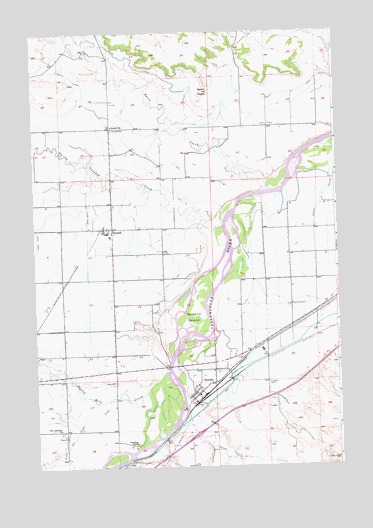
Huntley, MT USGS Topographic Map
Click on map above to begin viewing in our Map Viewer.

This topographic map contains these locations and features:
Feature Name Type Latitude Longitude GNIS ID View Map
02N27E01AABA01 WellWellN45.9577°W108.3037°813568View Map
02N27E02BDDB01 WellWellN45.9519°W108.3349°813530View Map
02N27E09DCDD01 WellWellN45.9297°W108.3693°813419View Map
02N27E10BBAD01 WellWellN45.9425°W108.3585°813489View Map
02N27E11DBAB01 WellWellN45.9361°W108.3293°813451View Map
02N27E12BAAA01 WellWellN45.9430°W108.3121°813493View Map
02N27E13BCCC01 WellWellN45.9227°W108.3212°813375View Map
02N27E15DAAA01 WellWellN45.9216°W108.3443°813371View Map
02N27E22BBCC01 WellWellN45.9113°W108.3626°813315View Map
02N27E23DBBB01 WellWellN45.9072°W108.3307°813270View Map
02N27E24DBDC01 WellWellN45.9033°W108.3090°813225View Map
02N27E27ADDA01 WellWellN45.8944°W108.3437°813166View Map
02N27E27BCCB01 WellWellN45.8944°W108.3629°813167View Map
02N27E34CBBD01 WellWellN45.8766°W108.3612°812997View Map
02N27E35BDAB01 WellWellN45.8816°W108.3337°813037View Map
02N27E36ADAC01 WellWellN45.8797°W108.3024°813022View Map
02N28E09DDBB01 WellWellN45.9319°W108.2512°813431View Map
02N28E09DDCC01 WellWellN45.9291°W108.2512°813411View Map
02N28E16C___01 WellWellN45.9169°W108.2526°813351View Map
03N27E24BDAD01 WellWellN45.9969°W108.3126°813713View Map
03N27E27BDAD01 WellWellN45.9819°W108.3543°813675View Map
03N27E27DDBA01 WellWellN45.9758°W108.3465°813657View Map
03N27E33ACCB01 WellWellN45.9663°W108.3735°813614View Map
03N27E34CCDC01 WellWellN45.9586°W108.3604°813574View Map
03N27E35CCBC01 WellWellN45.9611°W108.3415°813584View Map
03N27E36CBCC01 WellWellN45.9622°W108.3210°813591View Map
03N28E31DADB01 WellWellN45.9625°W108.2807°813596View Map
Crooked CreekStreamN45.9455°W108.2971°770317View Map
Deer PointSummitN45.9830°W108.3043°777133View Map
HuntleyPopulated PlaceN45.8994°W108.3015°772643View Map
Huntley CemeteryCemeteryN45.8988°W108.2787°772646View Map
Huntley Census Designated PlaceCensusN45.8995°W108.3054°2408411View Map
Huntley Post OfficePost OfficeN45.8976°W108.3063°2738314View Map
New Apostolic ChurchChurchN45.8861°W108.3654°774595View Map
Pryor CreekStreamN45.8875°W108.3160°789220View Map
Razor CreekStreamN45.9563°W108.2785°775606View Map
Scandia CemeteryCemeteryN45.9722°W108.3418°776255View Map
Scandia SchoolSchoolN45.9730°W108.3418°776256View Map
ShepherdPopulated PlaceN45.9436°W108.3424°776471View Map
Shepherd Census Designated PlaceCensusN45.9468°W108.3463°2408725View Map
Shepherd DivisionCivilN45.9289°W108.3627°1940704View Map
Shepherd Post OfficePost OfficeN45.9434°W108.3455°2738307View Map
Shepherd Volunteer Fire Department Station HeadquartersBuildingN45.9443°W108.3454°2546654View Map
Shepherd Volunteer Fire Department Storage FacilityBuildingN45.9443°W108.3461°2546458View Map
Spraklin IslandIslandN45.9202°W108.3085°776948View Map
Twelve Mile CreekStreamN45.9025°W108.3207°777823View Map
Vermilion RanchLocaleN45.8816°W108.3340°778014View Map
Worden Volunteer Fire Department Station 2 HuntleyBuildingN45.8926°W108.3126°2546481View Map
Yellowstone CountyCivilN45.9373°W108.2744°1719558View Map

Note: Coordinates in the location and feature list above are referenced to NAD83 datum.


Copyright (C) 2008-2025 Ryan Niemi / Sunset Dynamics ... All Rights Reserved