TopoQuest Logo
Do you find TopoQuest useful?
Help keep TopoQuest running and adding new maps/features by donating!
Bitcoin:  19c7KJd3qBynnjoSw5npx9KScwjBe4ifkT
Litecoin:  LXs6TkuXGGXo1vDsWCkWVdjQX94eUKd6ui
Home View Maps Find Maps Find Places Resources & Links


Adona, Arkansas Topographic Map

USGS Map Title: Adona, AR
USGS Map MRC: 35092A8
DRG (GeoTIFF) Download: o35092a8.tif


Neighboring USGS Topographic Map Quads:


  Holla Bend, AR  
35093B1
 

  Atkins, AR  
35092B8
 

  Morrilton West, AR  
35092B7
 

  Casa, AR  
35093A1
 

  Adona, AR  
35092A8
 

  Perryville, AR  
35092A7
 

  Nimrod, AR  
34093H1
 

  Aplin, AR  
34092H8
 

  Thornburg, AR  
34092H7


Map MRC Location:

N36°
W93°
N36°
W92°
H8 H7 H6 H5 H4 H3 H2 H1
G8 G7 G6 G5 G4 G3 G2 G1
F8 F7 F6 F5 F4 F3 F2 F1
E8 E7 E6 E5 E4 E3 E2 E1
D8 D7 D6 D5 D4 D3 D2 D1
C8 C7 C6 C5 C4 C3 C2 C1
B8 B7 B6 B5 B4 B3 B2 B1
A8 A7 A6 A5 A4 A3 A2 A1
N35°
W93°
N35°
W92°

Adona, AR USGS 1:24K Topographic Map Preview:
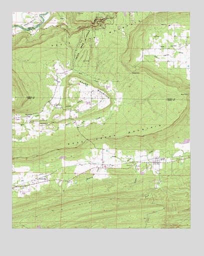
Adona, AR USGS Topographic Map
Click on map above to begin viewing in our Map Viewer.

This topographic map contains these locations and features:
Feature Name Type Latitude Longitude GNIS ID View Map
AdonaPopulated PlaceN35.0381°W92.8979°45796View Map
Adona Post OfficePost OfficeN35.0384°W92.8978°2781825View Map
Adona Volunteer Fire DepartmentBuildingN35.0374°W92.8972°2116058View Map
Aunt Dilly CemeteryCemeteryN35.0623°W92.9804°45975View Map
Barnes CemeteryCemeteryN35.1109°W92.9004°46101View Map
Blue PointCapeN35.0773°W92.8766°46758View Map
Cedar FallsFallsN35.1215°W92.9338°47601View Map
City of AdonaCivilN35.0400°W92.8991°2403065View Map
Clear Water LakeReservoirN35.0411°W92.9649°80511View Map
Clear Water Lake DamDamN35.0401°W92.9635°80510View Map
Danner CreekStreamN35.0404°W92.9160°48353View Map
Divide (historical)Populated PlaceN35.0895°W92.9688°66189View Map
Falloff BranchStreamN35.0718°W92.9679°48999View Map
Fowler CemeteryCemeteryN35.0362°W92.9163°49209View Map
Half Moon Lake FordCrossingN35.1168°W92.9974°70220View Map
Hamilton CemeteryCemeteryN35.0695°W92.9654°49801View Map
Hamiltons Store (historical)LocaleN35.0731°W92.9749°65214View Map
Higgins CemeteryCemeteryN35.1176°W92.8954°50097View Map
HomewoodPopulated PlaceN35.0301°W92.9766°57937View Map
Howell CreekStreamN35.0418°W92.9052°50369View Map
Liberty CemeteryCemeteryN35.0401°W92.8846°51090View Map
Little Rose CreekStreamN35.0598°W92.9921°51323View Map
Mulberry Church (historical)ChurchN35.0340°W92.9452°65235View Map
Mulberry CreekStreamN35.0376°W92.9393°52538View Map
Petit Jean Natural BridgeArchN35.0967°W92.9461°2571573View Map
Petit Jean State ParkParkN35.1173°W92.9377°53308View Map
Petit Jean State Park LakeReservoirN35.1243°W92.9208°79859View Map
Rose CreekPopulated PlaceN35.0647°W92.9897°2771904View Map
Rose Creek ChurchChurchN35.0659°W92.9866°54194View Map
Rose Creek MountainRidgeN35.0537°W92.9088°54195View Map
Round MountainSummitN35.0754°W92.9316°58530View Map
Sharps GapGapN35.0895°W92.9166°54739View Map
Township of HigginsCivilN35.0977°W92.8830°66440View Map
Township of Mountain (historical)CivilN35.0626°W92.9460°65234View Map
Township of Petit JeanCivilN35.0423°W92.9057°68938View Map
Township of Rose CreekCivilN35.0619°W92.9894°68940View Map
Township of White EagleCivilN35.0967°W92.9445°66453View Map
Welcome Home ChurchChurchN35.0609°W92.9807°56139View Map
West (historical)Populated PlaceN35.1248°W92.9441°66223View Map
Willenberg LakeReservoirN35.0351°W92.9102°80513View Map
Willenberg Lake DamDamN35.0351°W92.9102°80512View Map

Note: Coordinates in the location and feature list above are referenced to NAD83 datum.


Copyright (C) 2008-2024 Ryan Niemi / Sunset Dynamics ... All Rights Reserved