TopoQuest Logo
Do you find TopoQuest useful?
Help keep TopoQuest running and adding new maps/features by donating!
Bitcoin:  19c7KJd3qBynnjoSw5npx9KScwjBe4ifkT
Litecoin:  LXs6TkuXGGXo1vDsWCkWVdjQX94eUKd6ui
Home View Maps Find Maps Find Places Resources & Links


Thornburg, Arkansas Topographic Map

USGS Map Title: Thornburg, AR
USGS Map MRC: 34092H7
DRG (GeoTIFF) Download: o34092h7.tif


Neighboring USGS Topographic Map Quads:


  Adona, AR  
35092A8
 

  Perryville, AR  
35092A7
 

  Houston, AR  
35092A6
 

  Aplin, AR  
34092H8
 

  Thornburg, AR  
34092H7
 

  Martindale, AR  
34092H6
 

  Paron SW, AR  
34092G8
 

  Paron, AR  
34092G7
 

  Fourche SW, AR  
34092G6


Map MRC Location:

N35°
W93°
N35°
W92°
H8 H7 H6 H5 H4 H3 H2 H1
G8 G7 G6 G5 G4 G3 G2 G1
F8 F7 F6 F5 F4 F3 F2 F1
E8 E7 E6 E5 E4 E3 E2 E1
D8 D7 D6 D5 D4 D3 D2 D1
C8 C7 C6 C5 C4 C3 C2 C1
B8 B7 B6 B5 B4 B3 B2 B1
A8 A7 A6 A5 A4 A3 A2 A1
N34°
W93°
N34°
W92°

Thornburg, AR USGS 1:24K Topographic Map Preview:
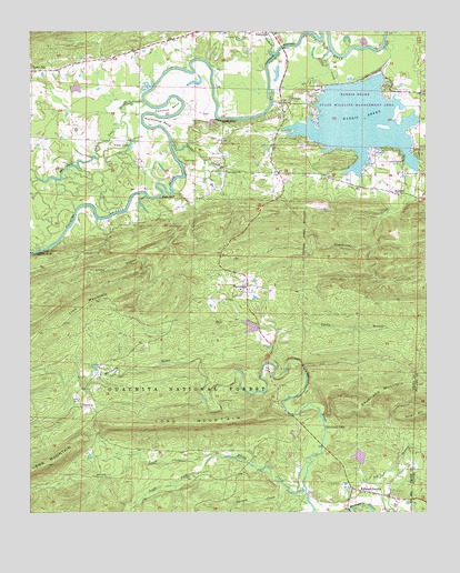
Thornburg, AR USGS Topographic Map
Click on map above to begin viewing in our Map Viewer.

This topographic map contains these locations and features:
Feature Name Type Latitude Longitude GNIS ID View Map
AntiochPopulated PlaceN34.9579°W92.7588°70449View Map
Antioch CemeteryCemeteryN34.9630°W92.7567°70451View Map
Antioch ChurchChurchN34.9576°W92.7588°65183View Map
Bell BranchStreamN34.9220°W92.7949°70616View Map
Brown CreekStreamN34.8804°W92.7882°70841View Map
Bull LakeLakeN34.9632°W92.8653°76462View Map
Bull Lake SloughLakeN34.9759°W92.8485°70922View Map
Calfneck BendBendN34.9798°W92.8313°70955View Map
Camp Pershing (historical)Populated PlaceN34.8793°W92.8116°65195View Map
Camp School (historical)SchoolN34.8801°W92.8085°65196View Map
Cardon CemeteryCemeteryN34.9859°W92.7832°71010View Map
Cedar CreekStreamN34.9940°W92.7985°71076View Map
Cherry HillPopulated PlaceN34.9901°W92.8743°76599View Map
Cherry Hill School (historical)SchoolN34.9840°W92.8743°65198View Map
Cherry Hill Volunteer Fire DepartmentBuildingN34.9854°W92.8741°2116265View Map
Clear LakeLakeN34.9705°W92.8434°76630View Map
Coffee CreekStreamN34.9951°W92.7802°71180View Map
Darbys PondReservoirN34.9765°W92.8177°81094View Map
Darbys Pond DamDamN34.9768°W92.8185°81093View Map
Deltic Farms LakeReservoirN34.8896°W92.7713°80531View Map
Deltic Farms Lake DamDamN34.8884°W92.7702°80530View Map
Greathouse CreekStreamN34.9643°W92.7524°71832View Map
HarmonyPopulated PlaceN34.8803°W92.7718°2742514View Map
Harmony Baptist ChurchChurchN34.8802°W92.7697°65215View Map
Harmony CemeteryCemeteryN34.8803°W92.7705°2742425View Map
Harris BrakeReservoirN34.9765°W92.7712°77127View Map
Harris Brake Auxillary DamDamN34.9884°W92.7635°81091View Map
Harris Brake DamDamN34.9868°W92.7752°80528View Map
Harris Brake Lake Fire Department Station 1BuildingN34.9636°W92.7963°2116534View Map
Harris Brake Lake Fire Department Station 2BuildingN34.9370°W92.8074°2116535View Map
Harris Brake Lake Fire Department Station 3BuildingN34.9840°W92.7581°2116533View Map
Harris Brake Public Fishing LakeReservoirN34.9868°W92.7752°80529View Map
Harris Brake State Wildlife Management AreaParkN34.9834°W92.7668°65216View Map
Henry LakeReservoirN34.9224°W92.8060°80533View Map
Henry Lake DamDamN34.9234°W92.8035°80532View Map
Hope CemeteryCemeteryN34.9822°W92.7927°72064View Map
Horseshoe BendBendN34.9765°W92.8357°72082View Map
Houston CreekStreamN34.9573°W92.8385°65219View Map
Jay Bird School (historical)SchoolN34.8912°W92.8199°65221View Map
Little Huston CreekStreamN34.9573°W92.8385°72399View Map
Lyons BranchStreamN34.9129°W92.7977°72523View Map
Millie BluffCliffN34.9770°W92.8152°72683View Map
Narrow CreekStreamN34.8806°W92.7943°72832View Map
Perryville CemeteryCemeteryN34.9981°W92.8088°73048View Map
Rankin School (historical)SchoolN34.9595°W92.7710°81336View Map
Satsuma School (historical)SchoolN34.9018°W92.8552°65256View Map
SatumaPopulated PlaceN34.9026°W92.8593°73484View Map
Sausmann FallsFallsN34.8973°W92.7824°73486View Map
Sausmann MountainSummitN34.9068°W92.7632°73487View Map
Slaty BluffCliffN34.9570°W92.8341°73603View Map
South Fork Brown CreekStreamN34.8904°W92.7835°73647View Map
ThornburgPopulated PlaceN34.9343°W92.8066°73864View Map
Thornburg Baptist ChurchChurchN34.9331°W92.8085°65265View Map
Township of MaumelleCivilN34.8915°W92.8490°68935View Map
Township of Rowland (historical)CivilN34.9251°W92.8029°65255View Map
Township of Union ValleyCivilN34.9633°W92.8146°68943View Map
Tyler ShoalsBarN34.9898°W92.8174°65267View Map
Tyndall CemeteryCemeteryN34.9665°W92.8274°73930View Map
Tyndall SloughStreamN34.9706°W92.8310°73931View Map
Union Valley Baptist ChurchChurchN34.9640°W92.8135°78627View Map
Union Valley School (historical)SchoolN34.9640°W92.8132°65268View Map
Watson BluffCliffN34.9429°W92.8707°74019View Map
Williams JunctionPopulated PlaceN34.8815°W92.7735°74167View Map
Williams Junction Volunteer Fire DepartmentBuildingN34.8808°W92.7689°2117319View Map
Winona Work CenterLocaleN34.9295°W92.8079°74438View Map

Note: Coordinates in the location and feature list above are referenced to NAD83 datum.


Copyright (C) 2008-2024 Ryan Niemi / Sunset Dynamics ... All Rights Reserved