TopoQuest Logo
Do you find TopoQuest useful?
Help keep TopoQuest running and adding new maps/features by donating!
Bitcoin:  19c7KJd3qBynnjoSw5npx9KScwjBe4ifkT
Litecoin:  LXs6TkuXGGXo1vDsWCkWVdjQX94eUKd6ui
Home View Maps Find Maps Find Places Resources & Links


Perryville, Arkansas Topographic Map

USGS Map Title: Perryville, AR
USGS Map MRC: 35092A7
DRG (GeoTIFF) Download: o35092a7.tif


Neighboring USGS Topographic Map Quads:


  Atkins, AR  
35092B8
 

  Morrilton West, AR  
35092B7
 

  Morrilton East, AR  
35092B6
 

  Adona, AR  
35092A8
 

  Perryville, AR  
35092A7
 

  Houston, AR  
35092A6
 

  Aplin, AR  
34092H8
 

  Thornburg, AR  
34092H7
 

  Martindale, AR  
34092H6


Map MRC Location:

N36°
W93°
N36°
W92°
H8 H7 H6 H5 H4 H3 H2 H1
G8 G7 G6 G5 G4 G3 G2 G1
F8 F7 F6 F5 F4 F3 F2 F1
E8 E7 E6 E5 E4 E3 E2 E1
D8 D7 D6 D5 D4 D3 D2 D1
C8 C7 C6 C5 C4 C3 C2 C1
B8 B7 B6 B5 B4 B3 B2 B1
A8 A7 A6 A5 A4 A3 A2 A1
N35°
W93°
N35°
W92°

Perryville, AR USGS 1:24K Topographic Map Preview:
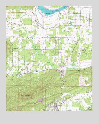
Perryville, AR USGS Topographic Map
Click on map above to begin viewing in our Map Viewer.

This topographic map contains these locations and features:
Feature Name Type Latitude Longitude GNIS ID View Map
AdaPopulated PlaceN35.1070°W92.8735°57247View Map
Ada ValleyValleyN35.0979°W92.8496°45778View Map
Ada Valley Fire StationBuildingN35.1075°W92.8729°2116057View Map
Bellevue School (historical)SchoolN35.0481°W92.8354°65190View Map
Brickey Private AirportAirportN35.1006°W92.7786°83784View Map
Buffalo School (historical)SchoolN35.0626°W92.8566°65193View Map
City of OppeloCivilN35.1003°W92.7736°2404438View Map
City of PerryvilleCivilN35.0122°W92.8029°2404506View Map
Crane CreekStreamN35.0618°W92.8177°65203View Map
Flat Cypress CreekStreamN35.0634°W92.8213°76936View Map
Fourche PinnacleSummitN35.0181°W92.8482°49202View Map
Gems Ambulance ServicesBuildingN35.0102°W92.7981°2119099View Map
Hallett CemeteryCemeteryN35.1245°W92.7807°49789View Map
Harper CemeteryCemeteryN35.0137°W92.7874°49879View Map
Harris CemeteryCemeteryN35.0354°W92.7921°49895View Map
Harris CreekStreamN35.0015°W92.7618°49901View Map
Haydon BranchStreamN35.0537°W92.7929°65218View Map
McGhee CemeteryCemeteryN35.0434°W92.8571°51842View Map
Mount Carmel Church (historical)ChurchN35.0515°W92.8463°65233View Map
OppeloPopulated PlaceN35.1012°W92.7677°53063View Map
Oppelo ChurchChurchN35.0834°W92.7674°53064View Map
Oppelo Police DepartmentBuildingN35.1021°W92.7689°2118794View Map
Oppelo Volunteer Fire StationBuildingN35.1018°W92.7704°2116906View Map
Payne LakeReservoirN35.1037°W92.7818°79853View Map
Payne Lake DamDamN35.1034°W92.7818°79852View Map
PerryPopulated PlaceN35.0476°W92.7941°53287View Map
Perry CemeteryCemeteryN35.0587°W92.7996°53290View Map
Perry County CourthouseBuildingN35.0043°W92.8024°65245View Map
Perry County Sheriff's OfficeBuildingN35.0050°W92.8040°2118791View Map
Perry MountainSummitN35.0393°W92.7749°58348View Map
Perry Police DepartmentBuildingN35.0482°W92.7940°2118793View Map
Perry Volunteer Fire DepartmentBuildingN35.0482°W92.7940°2116951View Map
PerryvillePopulated PlaceN35.0048°W92.8027°73047View Map
Perryville Elementary SchoolSchoolN35.0085°W92.8055°65246View Map
Perryville High SchoolSchoolN35.0098°W92.7953°65247View Map
Perryville Police DepartmentBuildingN35.0100°W92.8012°2118792View Map
Perryville Post OfficePost OfficeN35.0029°W92.8019°2781944View Map
Perryville Volunteer Fire DepartmentBuildingN35.0037°W92.8020°2116953View Map
Rehms CornerPopulated PlaceN35.0870°W92.7991°58481View Map
RiverviewPopulated PlaceN35.1159°W92.7843°78185View Map
Rocky Cypress CreekStreamN35.0631°W92.8213°54135View Map
Saint Elizabeth SchoolSchoolN35.0923°W92.8307°54322View Map
Sequoya ParkParkN35.1243°W92.7846°66220View Map
South Fouche Site Seven ReservoirReservoirN35.0128°W92.8255°81100View Map
Stover CemeteryCemeteryN35.1162°W92.7713°55258View Map
Sweet HomePopulated PlaceN35.0218°W92.7579°58721View Map
Sweet Home School (historical)SchoolN35.0229°W92.7529°65262View Map
Timberlake DamDamN35.0801°W92.8035°79854View Map
Timberlake ReservoirReservoirN35.0824°W92.8034°79855View Map
Town of PerryCivilN35.0448°W92.7935°2407100View Map
Township of Belle View (historical)CivilN35.0431°W92.8460°65188View Map
Township of BentleyCivilN35.1019°W92.7672°66434View Map
Township of Fourche LafaveCivilN35.0067°W92.8093°68931View Map
Township of LakeCivilN35.0540°W92.8061°68934View Map
Township of MartinCivilN35.1159°W92.8418°66444View Map
Township of Sweet Home (historical)CivilN35.0168°W92.7543°65263View Map
Wade CemeteryCemeteryN35.0429°W92.8718°55932View Map
Willow BendBendN35.1198°W92.8124°56413View Map
Wolfe CemeteryCemeteryN35.1084°W92.7799°56504View Map
Womack LakeReservoirN35.0418°W92.8535°80515View Map
Womack Lake DamDamN35.0418°W92.8535°80514View Map

Note: Coordinates in the location and feature list above are referenced to NAD83 datum.


Copyright (C) 2008-2024 Ryan Niemi / Sunset Dynamics ... All Rights Reserved