TopoQuest Logo
Do you find TopoQuest useful?
Help keep TopoQuest running and adding new maps/features by donating!
Bitcoin:  19c7KJd3qBynnjoSw5npx9KScwjBe4ifkT
Litecoin:  LXs6TkuXGGXo1vDsWCkWVdjQX94eUKd6ui
Home View Maps Find Maps Find Places Resources & Links


Indian Creek, Texas Topographic Map

USGS Map Title: Indian Creek, TX
USGS Map MRC: 31098E8
DRG (GeoTIFF) Download: o31098e8.tif


Neighboring USGS Topographic Map Quads:


  Bangs East, TX  
31099F1
 

  Brownwood, TX  
31098F8
 

  Zephyr, TX  
31098F7
 

  Brookesmith, TX  
31099E1
 

  Indian Creek, TX  
31098E8
 

  Blanket Springs, TX  
31098E7
 

  Elm Grove, TX  
31099D1
 

  Bowser, TX  
31098D8
 

  Regency, TX  
31098D7


Map MRC Location:

N32°
W99°
N32°
W98°
H8 H7 H6 H5 H4 H3 H2 H1
G8 G7 G6 G5 G4 G3 G2 G1
F8 F7 F6 F5 F4 F3 F2 F1
E8 E7 E6 E5 E4 E3 E2 E1
D8 D7 D6 D5 D4 D3 D2 D1
C8 C7 C6 C5 C4 C3 C2 C1
B8 B7 B6 B5 B4 B3 B2 B1
A8 A7 A6 A5 A4 A3 A2 A1
N31°
W99°
N31°
W98°

Indian Creek, TX USGS 1:24K Topographic Map Preview:
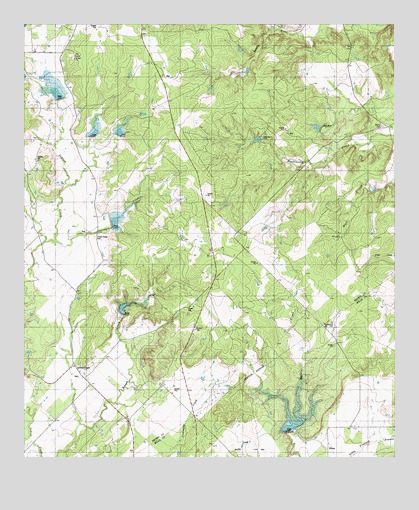
Indian Creek, TX USGS Topographic Map
Click on map above to begin viewing in our Map Viewer.

This topographic map contains these locations and features:
Feature Name Type Latitude Longitude GNIS ID View Map
Brownwood Lateral Watershed Number 25ReservoirN31.5918°W98.9222°1353005View Map
EbonyPopulated PlaceN31.5027°W98.8978°1379696View Map
Elkins CemeteryCemeteryN31.5954°W98.8795°1889978View Map
Indian CreekPopulated PlaceN31.5232°W98.9800°1379985View Map
Indian Creek CemeteryCemeteryN31.5638°W98.9767°1359940View Map
Northeast Lateral Watershed Number FourReservoirN31.5681°W98.9696°1364206View Map
Northeast Lateral Watershed Number OneReservoirN31.6050°W98.9891°1364205View Map
Northeast Lateral Watershed Number SixReservoirN31.5074°W98.9120°1364208View Map
Northeast Lateral Watersheds Number TwoReservoirN31.5938°W98.9767°1364209View Map
Soil Conservation Service Site 1 DamDamN31.5785°W98.9837°1859689View Map
Soil Conservation Service Site 1 ReservoirReservoirN31.5785°W98.9837°1859690View Map
Soil Conservation Service Site 2 DamDamN31.6002°W98.9787°1859699View Map
Soil Conservation Service Site 2 ReservoirReservoirN31.6002°W98.9787°1859700View Map
Soil Conservation Service Site 3 DamDamN31.6002°W98.9720°1859697View Map
Soil Conservation Service Site 3 ReservoirReservoirN31.6002°W98.9720°1859698View Map
Soil Conservation Service Site 4 DamDamN31.5685°W98.9720°1859695View Map
Soil Conservation Service Site 4 ReservoirReservoirN31.5681°W98.9696°1859696View Map
Soil Conservation Service Site 5 DamDamN31.5418°W98.9687°1859693View Map
Soil Conservation Service Site 5 ReservoirReservoirN31.5417°W98.9663°1859694View Map
Soil Conservation Service Site 6 DamDamN31.5068°W98.9137°1860797View Map
Soil Conservation Service Site 6 ReservoirReservoirN31.5093°W98.9104°1860798View Map
Soil Conservation Service Site Five ReservoirReservoirN31.5417°W98.9663°1364207View Map
Terrapin CreekStreamN31.5624°W98.9889°1369729View Map

Note: Coordinates in the location and feature list above are referenced to NAD83 datum.


Copyright (C) 2008-2025 Ryan Niemi / Sunset Dynamics ... All Rights Reserved