TopoQuest Logo
Do you find TopoQuest useful?
Help keep TopoQuest running and adding new maps/features by donating!
Bitcoin:  19c7KJd3qBynnjoSw5npx9KScwjBe4ifkT
Litecoin:  LXs6TkuXGGXo1vDsWCkWVdjQX94eUKd6ui
Home View Maps Find Maps Find Places Resources & Links


Blanket Springs, Texas Topographic Map

USGS Map Title: Blanket Springs, TX
USGS Map MRC: 31098E7
DRG (GeoTIFF) Download: o31098e7.tif


Neighboring USGS Topographic Map Quads:


  Brownwood, TX  
31098F8
 

  Zephyr, TX  
31098F7
 

  Democrat, TX  
31098F6
 

  Indian Creek, TX  
31098E8
 

  Blanket Springs, TX  
31098E7
 

  Mullin, TX  
31098E6
 

  Bowser, TX  
31098D8
 

  Regency, TX  
31098D7
 

  Big Valley North, TX  
31098D6


Map MRC Location:

N32°
W99°
N32°
W98°
H8 H7 H6 H5 H4 H3 H2 H1
G8 G7 G6 G5 G4 G3 G2 G1
F8 F7 F6 F5 F4 F3 F2 F1
E8 E7 E6 E5 E4 E3 E2 E1
D8 D7 D6 D5 D4 D3 D2 D1
C8 C7 C6 C5 C4 C3 C2 C1
B8 B7 B6 B5 B4 B3 B2 B1
A8 A7 A6 A5 A4 A3 A2 A1
N31°
W99°
N31°
W98°

Blanket Springs, TX USGS 1:24K Topographic Map Preview:
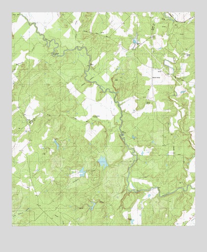
Blanket Springs, TX USGS Topographic Map
Click on map above to begin viewing in our Map Viewer.

This topographic map contains these locations and features:
Feature Name Type Latitude Longitude GNIS ID View Map
Blanket SpringsPopulated PlaceN31.5863°W98.7795°1379429View Map
Blanket Springs CemeteryCemeteryN31.6035°W98.7573°1352405View Map
Childress LakeReservoirN31.5135°W98.8003°1860796View Map
Childress Lake DamDamN31.5135°W98.8003°1860795View Map
Clayton Lake Number 1 SouthReservoirN31.5352°W98.8187°1860800View Map
Clayton Lake Number 1 South DamDamN31.5352°W98.8187°1860799View Map
Clayton Lake Number 2 NorthReservoirN31.5602°W98.8037°1860802View Map
Clayton Lake Number 2 North DamDamN31.5602°W98.8037°1860801View Map
Devils RiverStreamN31.6238°W98.8695°1373389View Map
Duke CrossingPopulated PlaceN31.5538°W98.7992°1379683View Map
Fisk CreekStreamN31.5582°W98.8017°1357367View Map
Fisk CrossingPopulated PlaceN31.5940°W98.8220°1379770View Map
Gobblers KnobSummitN31.5640°W98.8192°1358108View Map
Horseshoe BendBendN31.6018°W98.8425°1359628View Map
John Graves Dam Number 2DamN31.5352°W98.7537°1862669View Map
John Graves Dam Number 3DamN31.5385°W98.7537°1862667View Map
John Graves Dam Number 4DamN31.5568°W98.7520°1862665View Map
John Graves Dam Number 5DamN31.5318°W98.7520°1862663View Map
John Graves Lake Number 2ReservoirN31.5352°W98.7537°1862670View Map
John Graves Lake Number 3ReservoirN31.5385°W98.7538°1862668View Map
John Graves Lake Number 4ReservoirN31.5568°W98.7520°1862666View Map
John Graves Lake Number 5ReservoirN31.5318°W98.7520°1862664View Map
Long BranchStreamN31.5782°W98.8056°1374694View Map
Mackinally CreekStreamN31.6065°W98.8514°1362043View Map
Mars BranchStreamN31.5940°W98.8720°1362198View Map
Panther CreekStreamN31.5360°W98.7934°1364775View Map
Pecan CreekStreamN31.6049°W98.8264°1375392View Map
Rough CreekStreamN31.5204°W98.7953°1366910View Map
Soil Conservation Service Site 23 DamDamN31.6068°W98.7920°1859691View Map
Soil Conservation Service Site 23 ReservoirReservoirN31.6068°W98.7920°1859692View Map
Vaughan Ranch AirportAirportN31.5255°W98.7989°1387232View Map
Williams LakeReservoirN31.5476°W98.8446°1860804View Map
Williams Lake DamDamN31.5452°W98.8437°1860803View Map

Note: Coordinates in the location and feature list above are referenced to NAD83 datum.


Copyright (C) 2008-2025 Ryan Niemi / Sunset Dynamics ... All Rights Reserved