TopoQuest Logo
Do you find TopoQuest useful?
Help keep TopoQuest running and adding new maps/features by donating!
Bitcoin:  19c7KJd3qBynnjoSw5npx9KScwjBe4ifkT
Litecoin:  LXs6TkuXGGXo1vDsWCkWVdjQX94eUKd6ui
Home View Maps Find Maps Find Places Resources & Links


Zephyr, Texas Topographic Map

USGS Map Title: Zephyr, TX
USGS Map MRC: 31098F7
DRG (GeoTIFF) Download: o31098f7.tif


Neighboring USGS Topographic Map Quads:


  Owens, TX  
31098G8
 

  Blanket, TX  
31098G7
 

  Mercers Gap, TX  
31098G6
 

  Brownwood, TX  
31098F8
 

  Zephyr, TX  
31098F7
 

  Democrat, TX  
31098F6
 

  Indian Creek, TX  
31098E8
 

  Blanket Springs, TX  
31098E7
 

  Mullin, TX  
31098E6


Map MRC Location:

N32°
W99°
N32°
W98°
H8 H7 H6 H5 H4 H3 H2 H1
G8 G7 G6 G5 G4 G3 G2 G1
F8 F7 F6 F5 F4 F3 F2 F1
E8 E7 E6 E5 E4 E3 E2 E1
D8 D7 D6 D5 D4 D3 D2 D1
C8 C7 C6 C5 C4 C3 C2 C1
B8 B7 B6 B5 B4 B3 B2 B1
A8 A7 A6 A5 A4 A3 A2 A1
N31°
W99°
N31°
W98°

Zephyr, TX USGS 1:24K Topographic Map Preview:
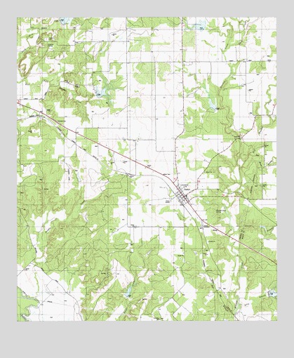
Zephyr, TX USGS Topographic Map
Click on map above to begin viewing in our Map Viewer.

This topographic map contains these locations and features:
Feature Name Type Latitude Longitude GNIS ID View Map
Ashton LakeReservoirN31.6302°W98.7699°1860806View Map
Ashton Lake DamDamN31.6285°W98.7720°1860805View Map
Bee BranchStreamN31.6268°W98.7709°1330300View Map
Blanket Creek SpringSpringN31.6700°W98.7800°1330843View Map
Blanket Creek Watershed Number 9ReservoirN31.7127°W98.7792°1330846View Map
Blanket Creek Watershed Number EightReservoirN31.7458°W98.7869°1330845View Map
Blanket Creek Watershed Reservoir Number TwentyReservoirN31.6360°W98.7521°1330850View Map
Brownwood Lateral Watershed Number 20ReservoirN31.7489°W98.8530°1331380View Map
Brownwood Lateral Watershed Number 21ReservoirN31.7182°W98.8344°1331381View Map
Brownwood Lateral Watershed Number 22ReservoirN31.6533°W98.8118°1331382View Map
Camp CreekStreamN31.7385°W98.7723°1331965View Map
Clark LakeReservoirN31.6637°W98.7571°1864014View Map
Clark Lake DamDamN31.6635°W98.7587°1864013View Map
Dirt House BranchStreamN31.6899°W98.7520°1334384View Map
Double CreekStreamN31.6346°W98.8670°1334524View Map
Dry Blanket CreekStreamN31.6868°W98.7681°1334636View Map
Groves BranchStreamN31.6618°W98.7706°1337048View Map
Jenkings SpringSpringN31.7427°W98.8575°1338705View Map
Jenkins CemeteryCemeteryN31.7413°W98.8612°1889805View Map
Kelly BranchStreamN31.6299°W98.7695°1339001View Map
Lancaster HillSummitN31.6804°W98.7920°1339601View Map
Sand Spring BranchStreamN31.6935°W98.7634°1346540View Map
Soil Conservation Service Site 20 DamDamN31.6352°W98.7553°1860786View Map
Soil Conservation Service Site 20 ReservoirReservoirN31.6352°W98.7553°1860787View Map
Soil Conservation Service Site 21 DamDamN31.7168°W98.8370°1859681View Map
Soil Conservation Service Site 22 DamDamN31.6335°W98.8237°1862759View Map
Soil Conservation Service Site 22 ReservoirReservoirN31.6335°W98.8237°1862760View Map
Soil Conservation Service Site 26a-1 DamDamN31.6635°W98.8620°1862996View Map
Soil Conservation Service Site 26a-1 ReservoirReservoirN31.6630°W98.8606°1862997View Map
Soil Conservation Service Site 8 DamDamN31.7468°W98.7853°1859705View Map
Soil Conservation Service Site 9 DamDamN31.7152°W98.7803°1859701View Map
Soil Conservation Service Site 9 ReservoirReservoirN31.7152°W98.7803°1859702View Map
Soil Conservation Service Site Eight ReservoirReservoirN31.7471°W98.7858°1859706View Map
Taylor DamDamN31.6818°W98.8453°1859683View Map
Taylor ReservoirReservoirN31.6844°W98.8457°1859684View Map
ZephyrPopulated PlaceN31.6760°W98.7948°1350730View Map
Zephyr CemeteryCemeteryN31.6640°W98.7856°1350731View Map
Zephyr Elementary SchoolSchoolN31.6765°W98.7945°2003805View Map
Zephyr High SchoolSchoolN31.6765°W98.7945°2003806View Map
Zephyr Post OfficePost OfficeN31.6754°W98.7947°2731819View Map
Zephyr Volunteer Fire DepartmentBuildingN31.6741°W98.7939°2551048View Map

Note: Coordinates in the location and feature list above are referenced to NAD83 datum.


Copyright (C) 2008-2025 Ryan Niemi / Sunset Dynamics ... All Rights Reserved