TopoQuest Logo
Do you find TopoQuest useful?
Help keep TopoQuest running and adding new maps/features by donating!
Bitcoin:  19c7KJd3qBynnjoSw5npx9KScwjBe4ifkT
Litecoin:  LXs6TkuXGGXo1vDsWCkWVdjQX94eUKd6ui
Home View Maps Find Maps Find Places Resources & Links


Indian Mills, New Jersey Topographic Map

USGS Map Title: Indian Mills, NJ
USGS Map MRC: 39074G6
DRG (GeoTIFF) Download: o39074g6.tif


Neighboring USGS Topographic Map Quads:


  Mount Holly, NJ  
39074H7
 

  Pemberton, NJ  
39074H6
 

  Browns Mills, NJ  
39074H5
 

  Medford Lakes, NJ  
39074G7
 

  Indian Mills, NJ  
39074G6
 

  Chatsworth, NJ  
39074G5
 

  Hammonton, NJ  
39074F7
 

  Atsion, NJ  
39074F6
 

  Jenkins, NJ  
39074F5


Map MRC Location:

N40°
W75°
N40°
W74°
H8 H7 H6 H5 H4 H3 H2 H1
G8 G7 G6 G5 G4 G3 G2 G1
F8 F7 F6 F5 F4 F3 F2 F1
E8 E7 E6 E5 E4 E3 E2 E1
D8 D7 D6 D5 D4 D3 D2 D1
C8 C7 C6 C5 C4 C3 C2 C1
B8 B7 B6 B5 B4 B3 B2 B1
A8 A7 A6 A5 A4 A3 A2 A1
N39°
W75°
N39°
W74°

Indian Mills, NJ USGS 1:24K Topographic Map Preview:
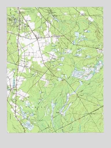
Indian Mills, NJ USGS Topographic Map
Click on map above to begin viewing in our Map Viewer.

This topographic map contains these locations and features:
Feature Name Type Latitude Longitude GNIS ID View Map
Bard BranchStreamN39.7700°W74.7109°874493View Map
BozuretownPopulated PlaceN39.8268°W74.6890°874880View Map
Bread and Cheese RunStreamN39.8667°W74.6938°874915View Map
Camp InawendiwinLocaleN39.8671°W74.6888°875133View Map
Camp Inawendiwin DamDamN39.8637°W74.6885°884040View Map
Camp Inawendiwin LakeReservoirN39.8628°W74.6859°884041View Map
Carranza MemorialParkN39.7773°W74.6321°875218View Map
Conte FarmsLocaleN39.8389°W74.7125°2516156View Map
Fox ChasePopulated PlaceN39.8565°W74.7263°876447View Map
FriendshipPopulated PlaceN39.8707°W74.6913°876523View Map
Hampton FurnacePopulated PlaceN39.7696°W74.6804°876920View Map
Hampton GatePopulated PlaceN39.8043°W74.6785°876921View Map
Hampton StationLocaleN39.7557°W74.6788°883071View Map
High CrossingPopulated PlaceN39.7693°W74.6440°877093View Map
Huckleberry HillSummitN39.8562°W74.7360°877276View Map
Indian MillsPopulated PlaceN39.7940°W74.7443°877333View Map
Indian Mills BrookStreamN39.7881°W74.7436°877334View Map
Indian Mills DamDamN39.7954°W74.7413°884039View Map
Indian Mills Elementary SchoolSchoolN39.7981°W74.7450°2373620View Map
Indian Mills LakeReservoirN39.7985°W74.7409°877335View Map
Indian Mills Sawmill DamDamN39.7932°W74.7474°884038View Map
Indian Mills Sawmill PondReservoirN39.7949°W74.7479°884037View Map
Indian Mills Volunteer Fire CompanyBuildingN39.7940°W74.7451°2401973View Map
Kenneth R Olson Middle SchoolSchoolN39.8478°W74.7070°2373627View Map
Meadford FarmsPopulated PlaceN39.8637°W74.7424°878232View Map
Moores MillPopulated PlaceN39.8615°W74.7252°878467View Map
Muskingum BrookStreamN39.7922°W74.7405°878674View Map
Oak ShadePopulated PlaceN39.8693°W74.7329°878913View Map
OrientalPopulated PlaceN39.8157°W74.7271°879013View Map
Roberts BranchStreamN39.7837°W74.6602°879735View Map
Russo's Fruit And Vegetable FarmLocaleN39.8408°W74.7072°2516166View Map
Seneca High SchoolSchoolN39.8570°W74.7177°2372792View Map
Shamong Emergency Medical ServicesBuildingN39.7940°W74.7453°2659994View Map
Skit BranchStreamN39.7637°W74.6794°880630View Map
Sooy PlacePopulated PlaceN39.8676°W74.6521°880700View Map
TabernaclePopulated PlaceN39.8440°W74.7102°881074View Map
Tabernacle Elementary SchoolSchoolN39.8465°W74.7095°2372478View Map
Tabernacle Fire CompanyBuildingN39.8613°W74.7326°2401652View Map
Tabernacle Rescue SquadBuildingN39.8455°W74.7082°2660214View Map
Township of ShamongCivilN39.7781°W74.7271°882084View Map
Township of TabernacleCivilN39.8193°W74.6551°882081View Map

Note: Coordinates in the location and feature list above are referenced to NAD83 datum.


Copyright (C) 2008-2025 Ryan Niemi / Sunset Dynamics ... All Rights Reserved