TopoQuest Logo
Do you find TopoQuest useful?
Help keep TopoQuest running and adding new maps/features by donating!
Bitcoin:  19c7KJd3qBynnjoSw5npx9KScwjBe4ifkT
Litecoin:  LXs6TkuXGGXo1vDsWCkWVdjQX94eUKd6ui
Home View Maps Find Maps Find Places Resources & Links


Browns Mills, New Jersey Topographic Map

USGS Map Title: Browns Mills, NJ
USGS Map MRC: 39074H5
DRG (GeoTIFF) Download: o39074h5.tif


Neighboring USGS Topographic Map Quads:


  Columbus, NJ  
40074A6
 

  New Egypt, NJ  
40074A5
 

  Cassville, NJ  
40074A4
 

  Pemberton, NJ  
39074H6
 

  Browns Mills, NJ  
39074H5
 

  Whiting, NJ  
39074H4
 

  Indian Mills, NJ  
39074G6
 

  Chatsworth, NJ  
39074G5
 

  Woodmansie, NJ  
39074G4


Map MRC Location:

N40°
W75°
N40°
W74°
H8 H7 H6 H5 H4 H3 H2 H1
G8 G7 G6 G5 G4 G3 G2 G1
F8 F7 F6 F5 F4 F3 F2 F1
E8 E7 E6 E5 E4 E3 E2 E1
D8 D7 D6 D5 D4 D3 D2 D1
C8 C7 C6 C5 C4 C3 C2 C1
B8 B7 B6 B5 B4 B3 B2 B1
A8 A7 A6 A5 A4 A3 A2 A1
N39°
W75°
N39°
W74°

Browns Mills, NJ USGS 1:24K Topographic Map Preview:
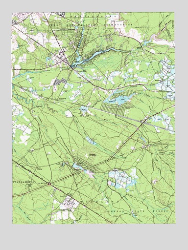
Browns Mills, NJ USGS Topographic Map
Click on map above to begin viewing in our Map Viewer.

This topographic map contains these locations and features:
Feature Name Type Latitude Longitude GNIS ID View Map
Adams LakeLakeN39.9233°W74.5636°883241View Map
Aletta Crichton Elementary SchoolSchoolN39.9555°W74.5907°2372221View Map
Alexander Denbo Elementary SchoolSchoolN39.9555°W74.5907°2372369View Map
Amphibious LakeReservoirN39.9988°W74.6036°884378View Map
Amphibious Lake DamDamN39.9982°W74.6024°883875View Map
Baffin BrookStreamN39.9499°W74.5312°874458View Map
Big Pine LakeLakeN39.9829°W74.5721°874759View Map
Bisphams Mill CreekStreamN39.9446°W74.6071°874777View Map
Bowkers RunStreamN39.9998°W74.5675°874871View Map
Browns MillsPopulated PlaceN39.9726°W74.5829°874981View Map
Browns Mills Census Designated PlaceCensusN39.9737°W74.5690°2389252View Map
Browns Mills Emergency SquadBuildingN39.9709°W74.5838°2659960View Map
Browns Mills Fire Company 1BuildingN39.9709°W74.5826°2401933View Map
Browns Mills JunctionPopulated PlaceN39.9484°W74.5899°874982View Map
Bucks Cove RunStreamN39.9549°W74.5436°875010View Map
Cooper BranchStreamN39.9023°W74.5563°875633View Map
Country LakeReservoirN39.9468°W74.5543°875668View Map
Country Lake EstatesPopulated PlaceN39.9426°W74.5440°875669View Map
Country Lake Estates Census Designated PlaceCensusN39.9489°W74.5410°2389364View Map
Country Lakes Emergency SquadBuildingN39.9529°W74.5498°2660126View Map
Country Lakes Volunteer Fire Company 1BuildingN39.9528°W74.5507°2401931View Map
Cranberry BranchStreamN39.9537°W74.5379°875697View Map
Deborah Heart and Lung Medical CenterHospitalN39.9770°W74.5851°2626648View Map
Deborah SanatoriumHospitalN39.9784°W74.5846°875837View Map
Deep Hollow PondLakeN39.9109°W74.5851°875847View Map
Deverson LakeReservoirN39.9088°W74.5747°883873View Map
Earlys CrossingPopulated PlaceN39.9087°W74.6057°876037View Map
Federal Correctional Institution - Fort DixBuildingN39.9990°W74.6191°2733242View Map
Four MilePopulated PlaceN39.8915°W74.5810°876438View Map
Four Mile CirclePopulated PlaceN39.8982°W74.5954°876439View Map
Gaunts BrookStreamN39.9836°W74.5094°876577View Map
Goodwater RunStreamN39.9886°W74.5115°876673View Map
Grant LakeLakeN39.9241°W74.5654°883240View Map
Gum SpringStreamN39.9398°W74.5843°876847View Map
Hanover FurnacePopulated PlaceN39.9815°W74.5263°876935View Map
Hanover LakeReservoirN39.9795°W74.5167°876936View Map
Hanover Lake DamDamN39.9801°W74.5246°883876View Map
Harker Wylie Elementary SchoolSchoolN39.9751°W74.5880°2372798View Map
Hartshorne Mill StreamStreamN39.9881°W74.5107°876982View Map
Isaiah Haines Elementary SchoolSchoolN39.9763°W74.5884°2372796View Map
Jacks RunStreamN39.9921°W74.5698°877381View Map
Joseph Stackhouse Elementary SchoolSchoolN39.9766°W74.5874°2373669View Map
Larkins RunStreamN39.9925°W74.5702°877674View Map
Laurel Hill SchoolSchoolN39.9762°W74.5882°877681View Map
Lebanon Forest Dam Number OneDamN39.9101°W74.5779°883872View Map
Lebanon LakeReservoirN39.9037°W74.5629°883878View Map
Lebanon Lake DamDamN39.9068°W74.5696°883877View Map
Lebanon Lake EstatesPopulated PlaceN39.9071°W74.5646°877719View Map
Lebanon Lakes Volunteer Fire CompanyBuildingN39.9061°W74.5638°2401963View Map
Little Pine LakeLakeN39.9894°W74.5701°877853View Map
Lower MillPopulated PlaceN39.9446°W74.6088°877969View Map
LZ 1 NLDC HeliportAirportN39.8901°W74.5815°884864View Map
Manson LakeLakeN39.9255°W74.5671°883239View Map
Mary Ann FurnaceLocaleN39.9409°W74.5790°883079View Map
McDonaldPopulated PlaceN39.9068°W74.5449°878214View Map
McDonalds BranchStreamN39.9027°W74.5567°878215View Map
Mid - State Correctional FacilityBuildingN39.9982°W74.5836°2733219View Map
Middle Branch Mount Misery BrookStreamN39.9172°W74.5144°878289View Map
Mirror LakeReservoirN39.9682°W74.5796°878414View Map
Mirror Lake DamDamN39.9682°W74.5796°883874View Map
Monroe LakeLakeN39.9225°W74.5616°883242View Map
Mount MiseryPopulated PlaceN39.9198°W74.5229°878559View Map
Mount Misery BrookStreamN39.9429°W74.5679°878560View Map
New Jersey Forest Fire Service B6BuildingN39.9801°W74.5828°2614496View Map
New Lisbon Developmental Center AmbulanceBuildingN39.8901°W74.5838°2659974View Map
Newbold RunStreamN39.9908°W74.5704°878772View Map
North Branch Mount Misery BrookStreamN39.9193°W74.5157°878832View Map
OngPopulated PlaceN39.9109°W74.6207°878993View Map
Ong RunStreamN39.9765°W74.5760°878994View Map
Pakim PondLakeN39.8800°W74.5318°879093View Map
Pole Bridge BranchStreamN39.9398°W74.5843°879402View Map
Presidential Lake EstatesPopulated PlaceN39.9165°W74.5649°879484View Map
Presidential LakesReservoirN39.9088°W74.5747°879485View Map
Presidential Lakes EstatesPopulated PlaceN39.9137°W74.5646°1867371View Map
Presidential Lakes Estates Census Designated PlaceCensusN39.9150°W74.5648°2389705View Map
Presidential Lakes Fire and RescueBuildingN39.9164°W74.5676°2401932View Map
Shinns BranchStreamN39.8996°W74.5612°880558View Map
Soldiers IslandIslandN39.9690°W74.5763°880680View Map
South Branch Mount Misery BrookStreamN39.9190°W74.5154°880713View Map
The Pine BarrensAreaN39.9501°W74.5163°883762View Map
Township of PembertonCivilN39.9562°W74.6000°882089View Map
Treasure IslandIslandN39.9707°W74.5729°881237View Map
Upper MillPopulated PlaceN39.9126°W74.5735°881390View Map
UptonPopulated PlaceN39.9348°W74.5240°881398View Map
WhitesbogPopulated PlaceN39.9593°W74.5093°881802View Map

Note: Coordinates in the location and feature list above are referenced to NAD83 datum.


Copyright (C) 2008-2024 Ryan Niemi / Sunset Dynamics ... All Rights Reserved